

New Mexico map
San Juan County map
About 120,817 people live here (Census Bureau, 2024 estimate). The sheet's index lists 300 streets; New Mexico State Highway 371, Navajo Route 36 and Navajo Route 30 cross the most grid squares. Things to do inside the boundary: Aztec, Aztec Ruins National Monument and Bisti/De-Na-Zin Wilderness.
Open the map (PDF, US Letter)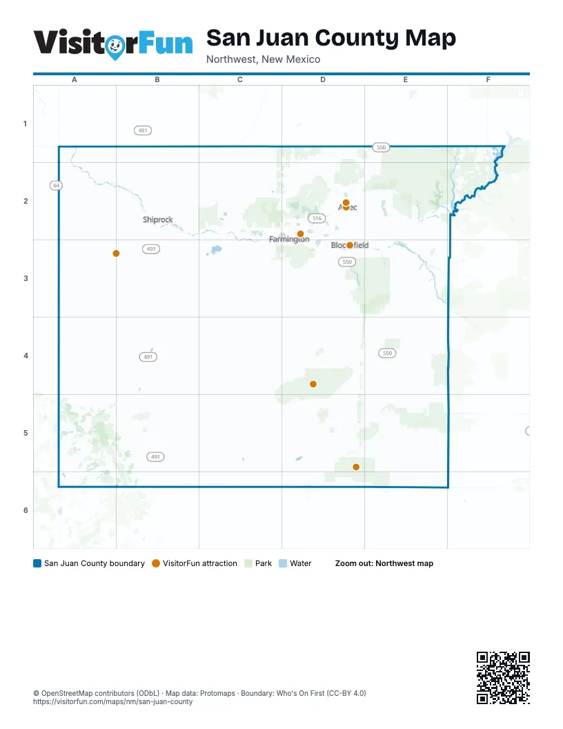
Street index of San Juan County
Each street on the sheet and the grid squares it crosses.
- New Mexico State Highway 371C3, D3, C4, C5
- Navajo Route 5B4, C4
- Navajo Route 36B2, C2, B3, C3
- Navajo Route 13A3, B3
- New Mexico State Highway 134A5, B5, A6
- La Plata HighwayD1, C2, D2
- Navajo Dam RoadD2, E2
- Bloomfield HighwayD3
- East Main StreetD2
- Pinon Hills BoulevardC2, D2
- West Main StreetC2, D2, D3
- Navajo Route 12A5, A6
- West Aztec BoulevardD2
- Crouch Mesa RoadD2, D3
- North 1st StreetD2, D3
- West Murray DriveD2, D3
- South Bloomfield BoulevardD3
- North Aztec BoulevardD2
- West Broadway BoulevardD3
- East Broadway AvenueD2, D3
- Bisti HighwayC3, D3
- Indian Route 36B3
- West Broadway StreetD2
- Troy King RoadC2
- East Broadway BoulevardD3
- South Main AvenueD2
- East Murray DriveD3
- South Butler AvenueD2, D3
- South Browning ParkwayD2, D3
- West Pinon StreetD3
- North Browning ParkwayD2
- North Main AvenueD2
- Northeast Aztec BoulevardD2
- East Pinon StreetD2, D3
- West Chaco StreetD2
- Upper Fruitland HighwayC3
- Navajo TrailA1
- Industrial AvenueD2
- West Broadway AvenueD3
- US 491B1
- Teec Nos Pos–State Line HighwayA2
- Animas River BridgeD2
- US 550 SouthD3
- Don Glesson BridgeC5
- East Broadway StreetD3
- Navajo Route 5000B4, A5, B5
- Navajo Route 34A4, B4
- State Highway 57E4, D5, E5
- Pueblo Pintado RoadE5, F5, E6
- Chaco Entrance RoadE5, E6
- Navajo Route 19B4, A5, B5
- Road 7010D3
- North Light Plant RoadD2
- Navajo Route 3005C3
- Road 7800E5
- Navajo Route 5001A5, B5
- Navajo Route 3003C3, D3
- New Mexico State Highway 302D3
- Road 6100C2
- Road 4599E2, E3
- Road 5500D3
- Road 7150D3, D4
- APS Access RoadC2, C3
- Road 1191D1, D2
- Road 6480C2
- College BoulevardD2
- East 30th StreetD2
- Road 390D2
- North Butler AvenueD2
- East 20th StreetD2
- West Apache StreetC2, D2
- Wildflower ParkwayD2, D3
- Indian Service Route 5000B4, B5
- Municipal DriveD2
- San Juan BoulevardD2
- Southside River RoadD3
- Road 6200C2
- Twin Peaks BoulevardC2
- Road 1130D1
- Road 6500C2
- English RoadD2
- Road 6675C2
- South Miller AvenueD2, D3
- North Auburn AvenueD2
- North Sullivan AvenueD2
- Hutton AvenueD2
- West 30th StreetD2
- Road 6400C2
- Sullivan AvenueD2
- South Lake StreetD2, D3
- Butler AvenueD2
- 30th StreetD2
- Scott AvenueD2
- Ruth LaneD3
- South Auburn AvenueD2, D3
- Mc Cormick School RoadD3
- North Airport DriveD2
- East Apache StreetD2
- West 20th StreetD2
- Brookside DriveD2
- Navajo Route 9703A6
- North Hutton AvenueD2
- Navajo Route 30A4, A5, A6, B6
- Navajo Route 5020A2, A3
- De-Na-Zin RoadD4, E4, D5
- Navajo Route 5081C4, C5
- Navajo Route 5091B1, B2
- Road 7250C4, D4
- Road 7650D5, E5
- Navajo Route 5080C4
- Navajo Route 5082C3, C4
- Road 7100D3, D4
- Navajo Route 5030A1, B1, B2
- Navajo Route 364A1, A2, B2
- Angel Peak RoadD3, E3
- Glade RoadD2
- Sanostee RoadA3, A4
- Navajo Route 5010A3, A4, A5
- Navajo Route 69B5
- Road 7520D4, E4
- Navajo Route 5013A3, A4
- Road 7980D5, E5
- Navajo Route 9652C5, B6, C6
- Navajo Route 7057C5, C6
- Navajo Route 5017B3, C3
- Huerfano RoadE3, E4
- Road 3000D2
- Road 7890E5
- Indian Service Route 5092B4
- Road 4990D3, E3
- Indian Service Route 321A5, A6
- Road 2900D2, E2
- Indian Route 205C1, C2
- Road 7870D5
- Road 7115D3, D4
- Navajo Route 5016A4, B4
- County Road 7425E4
- County Road 7150D4
- Farm RoadB2
- County Road 7555C5, D5
- Navajo Route 63A2
- Road 7610D4, E4
- Navajo Route 342A4
- Navajo Route 5005A4, B4
- Road 7300D4, E4
- Navajo Route 57B2
- Road 7515E4
- Chaco Loop RoadD5, E5, D6, E6
- Turks Toast RoadC2
- County Road 7060C5, D5
- Road 7820E5
- County Road 7125D4
- Road 7080D3
- Indian Service Route 4002D3
- Road 7970E5
- Navajo Route 5085C3, C4, C5
- Blanco Canyon RoadE3, E4
- County Road 7750D5, D6
- Road 4018F2
- Indian Service Route 5009B4
- Isr 7170A5
- County Road 7710D5
- Navajo Route 7060C5
- Road 7635E4, E5
- Navajo Route 4095C3
- Road 7830E5
- Pine River RoadF1, F2
- Road 3950D2
- Road 3100D2
- County Road 7290C4, C5
- Road 7940E5
- Navajo Route 693B5
- Indian Service Route 9652B6, C6
- East Glade BypassD2
- Pipeline RoadE5, F5
- Road 4017F2
- Navajo Route 5111A2
- Indian Serv Rt 211C1, C2
- Indian Service Route 5014B3
- County Road 7675E4
- Navajo Route 321A5, A6
- Navajo Route 5205B5
- Hood Mesa TrailD2
- Navajo Route 367C2, C3
- Navajo Route 5021A3
- Isr 32AA5, A6
- Road 7270D4
- BIA-7102C5, D5
- Cereza Canyon RoadE3, F3
- Road 3050D2
- Road 3536D2
- North Dustin AvenueD2
- County Road 7260D4
- Indian Service Route 3256B4
- Road 7825E5
- Foothills DriveD2
- Road 1300D1, D2
- Road 5290D2, D3
- Navajo Route 365C2, C3
- Chaco Canyon RoadD6, E6
- County Road 7997E4, E5
- Old La Plata Mine Haul RoadD1, D2
- Navajo Route 5070B2
- County Road 7786E4, E5
- North 4104C3
- Navajo Route 132A3
- North 4059C3
- Road 6800C2
- East Blanco BoulevardD3
- Road 7960E5
- Navajo Route 571B2
- Road 2772E2
- Road 3535D2
- Road 7840E5
- Navajo Route 3211A5, A6
- Old Aztec HighwayD2
- Road 7698E4
- Road 6700C2
- County Road 459E4
- Navajo Route 5022B4
- County Road 7280D4
- Navajo Route 5009B5
- Navajo Route 5006B5
- Barker Dome Access RoadC2, D2
- old Navajo 4063C3
- Indian Service Route 9651B5
- Nacajo Route 192B5
- Sunrise ParkwayD2
- Road 7965E5
- County Road 7835E5
- Navajo Route 192B4, B5
- Lakewood StreetD2
- ArizonaD2
- Navajo Route 5071B2
- Rd 5512D3
- El Paso RoadE4
- Road 4020F1
- County Road 7297C5
- County Road 7730D5
- Andrea DriveD2, D3
- Road 4012F1
- Road 2755D2, E2
- West Blanco BoulevardD3
- North Mesa Verde AvenueD2
- Indian Service Route 9603A5
- Country Club DriveD2
- Indian Service Rt 10BC5
- West Navajo StreetC2, D2
- Navajo Route 7059D6
- Bluff RoadB2
- Navajo Route 5038A2
- Navajo Route 9604A5
- County Road 7998F4, E5, F5
- County Road 7732D5
- Cliffside DriveD2
- Ruins RoadD2
- Farmington AvenueD2
- East Navajo StreetD2
- Largo StreetD2
- Logging Road 7190A5
- Morningstar DriveD2
- Road 7513E5
- Schofield LaneD2
- Road 2550E2
- North Orchard AvenueD2
- Indian Service Route 5010B3, A4
- Indian Service Route 322A6
- County Road 7160D4
- Navajo Route 5027A2
- Road 3900D2
- West Maple StreetD3
- NavajoRoute 7059D6
- old Indian Service Route 363C3
- Road 4008F1
- Road 8350C3
- Navajo Route 72A6
- Road 3450D2
- North Fairview AvenueD2
- Fairgrounds RoadD2
- Road 4025F1
- County Road 1424D2
- County Road 7776E4
- Saiz LaneD2, D3
- Navajo Route 5003B5
- West Arrington StreetD2
- Navajo Route 509B2
- Navajo Route 5011A4, B4, B5
- County Road 7295C4, C5
- County Road 1330D2
- North Wall AvenueD2
- Kingsway DriveD2
- Road 3150D2
- South Dustin RoadD2, D3
- Road 3400D2
- Vine AvenueD2
- North Knudsen AvenueD2
- Sunset AvenueD2
- Indian Service Route 5083B3
- Navajo Route 5012 (Sanostee Road)A3, A4
- Wildflower Mesa DriveD2, D3
Things to do on the San Juan County map
Places on the map
- Ah-Shi-Sle-Pah Wilderness
- Alien Run Recreation Area
- Angel Peak Scenic Area
- Armenta Wash Riparian Area
- Aztec
- Aztec Ruins National Monument
- B Square Ranch
- Beclabito
- Berg Park
- Betonnie Tsosie Fossil Area
- Bisti/De-Na-Zin Wilderness
- Black Lake
- Blanco River Tract
- Blanco Wash
- Blanco Wash Riparian Area
- Bloomfield
- Bohanon Canyon Complex Fossil Area
- Captain Tom Reservoir
- Carrizo Creek
- Cereza Canyon Riparian Area
- Chaco Culture National Historical Park
- Confluence Park
- Crystal
- Cutter Canyon Riparian Area
- Cutter Reservoir
- Dunes OHV Area
- East La Plata Wildlife Area
- Glade Run Recreation Area
- Kutz Canyon Paleontological Area
- Kutz Wash Reach Riparian Area
- Largo Canyon Riparian Area
- Lybrook Fossil Area
- Middle Mesa Wildlife Area
- Negro Canyon Recreation Area
- Pinon Mesa Fossil Area
- Pinon Mesa Recreation Area
- Rattlesnake Canyon Wildlife Area
- Reese Canyon Wildlife Area
- Rock Garden Recreation Area
- Thomas Canyon Recreation Area
© OpenStreetMap contributors, Open Database License, openstreetmap.org/copyright · Map data: Protomaps · Boundary: Who's On First (CC-BY 4.0); Quattroshapes (CC BY 2.0)