

New York map
Canarsie map
A printable two-page map of Canarsie (Brooklyn, New York), drawn by VisitorFun from OpenStreetMap. Page two is the street index: every street on the sheet with its grid square, the same list as below.
Open the map (PDF, US Letter)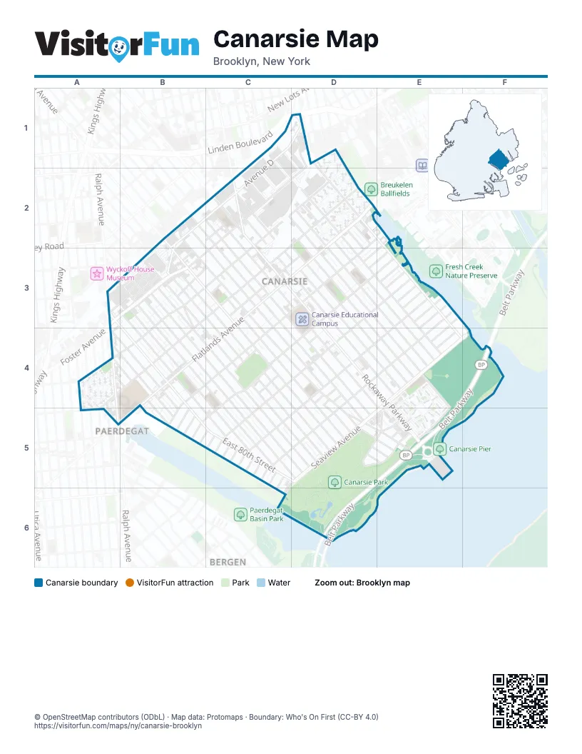
Street index of Canarsie
Each street on the sheet and the grid squares it crosses.
- Avenue DC1, D1, B2, C2, B3
- East 105th StreetC1, D2, E3, E4
- Bank StreetD1
- Dewitt AvenueD1
- East 108th StreetD1, D2, E2, E3, F4
- Foster AvenueD1, C2, D2, A3, B3
- Hinsdale StreetD1
- Linden BoulevardD1
- Snediker AvenueD1
- Stanley AvenueD1
- Van Sinderen AvenueD1
- Williams AvenueD1, D2
- East 92nd StreetB2, B3, C3, C4, D4, D5, E5
- East 93rd StreetB2, D4, D5, E5
- East 94th StreetB2, C2, C3, D4, D5
- East 95th StreetB2, C2, D4, D5, E5
- Nolans LaneB2, C2
- Remsen AvenueB2, B3, C3, C4, D5
- East 100th StreetC2, D2, D3, E4
- East 101st StreetC2, D2, D3, E4
- East 102nd StreetC2, D2, D3, E4, E5
- East 96th StreetC2, C3, D3, D4, E5
- East 98th StreetC2, C3, D3, D4, E4
- East 99th StreetC2, C3, D3, D4, E4
- Farragut RoadC2, D2, B3, C3, A4, B4
- Rockaway AvenueC2
- Rockaway ParkwayC2, C3, D4, E4, E5
- Avenue JD2, E2, D3, B4
- East 103rd StreetD2, D3, E4
- East 104th StreetD2, D3, E4
- East 106th StreetD2, D3
- East 107th StreetD2
- Flatlands AvenueD2, C3, B4
- Glenwood RoadD2, C3, A4, B4, A5
- Flatlands 1st StreetE2, D3
- Chase CourtA3, B3
- East 80th StreetA3, B4, B5, C5, D5
- Ralph AvenueA3, A4
- Bayview PlaceB3, C3
- Bedell LaneB3, C3
- Center Market StreetB3
- East 81st StreetB3, B4, C5
- East 82nd StreetB3, C5
- East 83rd StreetB3, B4, C5
- East 84th StreetB3, C5, D5
- East 85th StreetB3, C4, C5, D5
- East 86th StreetB3, B4, C5, D5
- East 87th StreetB3, C4, C5, D5
- East 88th StreetB3, C4, D5
- East 89th StreetB3, C4, D5
- Krier PlaceB3
- North Market StreetB3
- Preston CourtB3
- South Market StreetB3
- Varkens Hook RoadB3, B4
- Conklin AvenueC3, D3
- Durland PlaceC3
- East 91st StreetC3, D5, E5
- Rose StreetC3
- School LaneC3
- Skidmore LaneC3
- Smith's LaneC3
- Avenue KD3, E3, C4, D4, B5
- Flatlands 2nd StreetD3, E3
- Trucklemans LaneD3
- Avenue LE3, C4, D4, C5
- Avenue ME3, D4, C5
- Avenue NE3, D4, E4, C5, D5
- Flatlands 3rd StreetE3
- Flatlands 4th StreetE3
- Flatlands 5th StreetE3
- Flatlands 6th StreetE3
- Flatlands 7th StreetE3
- Flatlands 8th StreetE3, E4
- Flatlands 9th StreetE3, E4
- East 56th StreetA4
- East 58th StreetA4, A5
- East 59th StreetA4
- East 76th StreetA4, B4
- East 77th StreetA4, B4, B5
- East 78th StreetA4, B4, B5
- East 79th StreetA4, B4, B5
- Paerdegat Avenue SouthA4, A5
- Paerdegat 1st StreetB4, B5
- Church LaneC4
- Stillwell PlaceC4
- Canarsie RoadD4, D5, E5
- Holmes LaneD4
- Kaufman PlaceD4
- Matthews PlaceD4, D5
- Rost PlaceD4
- Schenck PlaceD4
- Belt ParkwayE4, F4, E5, D6
- Flatlands 10th StreetE4
- Seaview AvenueE4, F4, C5, D5, C6
- Avenue HA5
- East 57th StreetA5
- Paerdegat 2nd StreetB5
- Paerdegat 3rd StreetB5
- Paerdegat 4th StreetB5
- Paerdegat 5th StreetB5, C5
- Paerdegat Avenue NorthB5, C6
- Paerdegat 10th StreetC5
- Paerdegat 11th StreetC5
- Paerdegat 12th StreetC5
- Paerdegat 13th StreetC5
- Paerdegat 14th StreetC5
- Paerdegat 15th StreetC5, C6
- Paerdegat 6th StreetC5
- Paerdegat 7th StreetC5
- Paerdegat 8th StreetC5
- Paerdegat 9th StreetC5
- Schenck StreetD5, E5
- Skidmore AvenueD5, E5
- Skidmore PlaceD5
- Saint Jude PlaceE5
- Seaview CourtE5
- Shore Parkway Service RoadE5
Places on the map
- Bay View Houses
- Bayview Playground
- Beraca Baptist Church
- Bildersee Playground
- BJ's Wholesale Club
- Breukelen Houses
- Canarsie Cemetery
- Canarsie Community Reformed Church
- Canarsie Educational Campus
- Canarsie Park
- Canarsie Pier
- Canarsie Skate Park
- Canarsie-Rockaway Parkway
- Chase
- Church At The Rock
- Congregation Beth Tikvah
- Crown Ministries
- Curtis Playground
- Daybreak Ministries
- Dollar General
- East 105th Street
- Faith Redeeming Church of God
- First Church of Brooklyn
- First Haitian Baptist Church
- Foodsaver NY Retail
- Glenwood Houses
- Glenwood Playground
- Harvestime Tabernacle
- Holy Family Roman Catholic Church
- I.S. 211 - John Wilson Intermediate School
- I.S. 68 - Isaac Bildersee Intermediate School
- Ideal Food Basket
- Jamaica Bay Branch Brooklyn Public Library
- Key Food
- KFC
- Kingdom Hall of Jehovah's Witnesses
- M.S. 961- Lenox Academy
- McDonald's
- NYPD 69th Precinct
- One Hundred Percent Playground
Next to Canarsie
- Paerdegat
© OpenStreetMap contributors (ODbL) · Map data: Protomaps · Boundary: Who's On First (CC-BY 4.0)