

New York map
Brooklyn map
A printable two-page map of Brooklyn (Kings County, New York City, New York), drawn by VisitorFun from OpenStreetMap. Page two is the street index: every street on the sheet with its grid square, the same list as below.
Open the map (PDF, US Letter)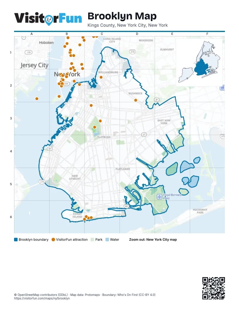
Street index of Brooklyn
Each street on the sheet and the grid squares it crosses.
- Ash StreetC1
- Box StreetC1
- Brooklyn-Queens ExpresswayC1, D1, B2, C2, B3, B4
- Commercial StreetC1
- Franklin StreetC1
- Greenpoint AvenueC1
- Humboldt StreetC1
- Kent AvenueC1, C2
- Kingsland AvenueC1
- Manhattan AvenueC1
- McGuinness BoulevardC1
- McGuinness Boulevard SouthC1
- Meeker AvenueC1, D1, C2
- Monitor StreetC1
- Norman AvenueC1, D1
- North 10th StreetC1, C2
- North 11th StreetC1
- North 14th StreetC1
- Paidge AvenueC1
- Provost StreetC1
- Pulaski BridgeC1
- Union AvenueC1, C2
- Wythe AvenueC1, C2
- Bridgewater StreetD1
- Cherry StreetD1
- Lombardy StreetD1
- Van Dam StreetD1
- Vandervoort AvenueD1, D2
- Varick AvenueD1
- Varick StreetD1
- Adams StreetB2
- Atlantic AvenueB2, C3, D3, E3
- Boerum PlaceB2
- Brooklyn BridgeB2
- Brooklyn Bridge BoulevardB2
- Brooklyn-Battery TunnelB2, B3
- Cadman Plaza WestB2
- Columbia StreetB2, B3
- Concord StreetB2
- Congress StreetB2
- Court StreetB2, B3
- Degraw StreetB2, B3
- Flatbush Avenue ExtensionB2, C2
- Flatbush Avenue Extension (lower level)B2
- Front StreetB2, C2
- Fulton MallB2, C2
- Furman StreetB2
- Hicks StreetB2, B3
- Jay StreetB2
- Joralemon StreetB2
- Middagh StreetB2
- Nassau StreetB2, C2
- Old Fulton StreetB2
- Prospect StreetB2
- Sands StreetB2, C2
- Schermerhorn StreetB2, C2
- Smith StreetB2, B3
- Tillary StreetB2, C2
- Van Brunt StreetB2, B3
- Washington StreetB2
- York StreetB2, C2
- 3rd AvenueC2, B3, C3, B4, A5
- Ashland PlaceC2
- Bedford AvenueC2, C3, C4, C5, C6
- Borinquen PlaceC2
- BroadwayC2, D2, D3
- Bushwick AvenueC2, D2, D3
- Classon AvenueC2, C3
- Clymer StreetC2
- DeKalb AvenueC2
- Division AvenueC2
- Flatbush AvenueC2, C3, C4, D5, D6, E6
- Flushing AvenueC2, D2
- Franklin AvenueC2, C3
- Fulton StreetC2, C3, D3, E3
- Gold StreetC2
- Grand StreetC2, D2
- Harrison AvenueC2
- Havemeyer StreetC2
- Hewes StreetC2
- Hudson AvenueC2
- Lafayette AvenueC2
- Lee AvenueC2
- Lorimer StreetC2
- Marcy AvenueC2
- Metropolitan AvenueC2, D2
- Myrtle AvenueC2, D2
- Navy StreetC2
- North Portland AvenueC2
- Nostrand AvenueC2, C3, C4, C5, C6, D6
- Park AvenueC2
- Rodney StreetC2
- Roebling StreetC2
- Taylor StreetC2
- Vanderbilt AvenueC2, C3
- Wallabout StreetC2
- Washington AvenueC2, C3
- Williamsburg BridgeC2
- Williamsburg Street EastC2
- Williamsburg Street WestC2
- Cooper AvenueD2
- Cooper StreetD2, D3
- Cypress AvenueD2
- Gardner AvenueD2
- Cypress Hills StreetE2
- Etna StreetE2, E3
- Jamaica AvenueE2, D3, E3
- 17th StreetB3
- 18th StreetB3, C3, C4
- 19th StreetB3, C3
- 1st AvenueB3, B4
- 20th StreetB3, C3, C4
- 39th StreetB3, B4
- 4th AvenueB3, C3, B4, A5
- 5th AvenueB3, C3, B4, A5, B5
- 6th AvenueB3, C3, B4, B5
- 7th AvenueB3, C3, B4, B5
- 9th StreetB3, C3
- Bay StreetB3
- Beard StreetB3
- Calder PlaceB3
- Clinton StreetB3
- Gowanus ExpresswayB3, B4, A5, B5
- Gowanus Expressway (HOV)B3, B4, A5, B5
- Halleck StreetB3
- Hamilton AvenueB3
- Prospect AvenueB3, C3, C4
- Prospect ExpresswayB3, C3, C4
- Union StreetB3, C3
- West 9th StreetB3
- 10th AvenueC3
- 11th AvenueC3
- Bartel Pritchard SquareC3
- Brooklyn AvenueC3
- Eastern ParkwayC3, D3
- Empire BoulevardC3, D3
- Grand Army PlazaC3
- McDonald AvenueC3, C4, C5, C6
- Ocean AvenueC3, C4, C5, C6
- Parkside AvenueC3, C4
- Plaza Street EastC3
- Plaza Street WestC3
- Prospect Park SouthwestC3, C4
- Prospect Park WestC3
- Rogers AvenueC3, C4
- Terrace PlaceC3, C4
- Avenue DD3, D4
- Buffalo AvenueD3
- East 98th StreetD3
- East New York AvenueD3
- Hegeman AvenueD3
- Highland BoulevardD3, E3
- Howard AvenueD3
- Jackie Robinson ParkwayD3
- Kings HighwayD3, D4, B5, C5, D5
- Liberty AvenueD3, E3
- Linden BoulevardD3, E3, C4, D4
- New Lots AvenueD3, E3
- Pacific StreetD3
- Pennsylvania AvenueD3, E3, E4
- Pitkin AvenueD3, E3
- Remsen AvenueD3, D4
- Rockaway AvenueD3, D4
- Rockaway ParkwayD3, D4, E4
- Sackman StreetD3
- Sutter AvenueD3, E3
- Tapscott StreetD3
- Troy AvenueD3
- Utica AvenueD3, D4, D5
- Van Sinderen AvenueD3
- 101st AvenueE3
- Belt ParkwayE3, A4, B4, D4, E4, A5, B5, D5, B6, C6, D6
- Dumont AvenueE3
- Erskine StreetE3, E4
- Flatlands AvenueE3, D4, E4, C5, D5
- Force Tube AvenueE3
- Fountain AvenueE3
- Highland PlaceE3
- North Conduit BoulevardE3
- Ridgewood AvenueE3
- Seaview AvenueE3, D4, E4
- South Conduit AvenueE3
- South Conduit BoulevardE3
- Van Siclen AvenueE3, E4
- 86th StreetA4, B4, B5, C5, C6
- Bay Ridge AvenueA4, B4
- Bay Ridge ParkwayA4, B4, B5
- Shore RoadA4, A5
- Shore Road DriveA4, B4
- Wakeman PlaceA4, B4
- 13th AvenueB4, B5
- 14th AvenueB4, C4, B5
- 2nd AvenueB4
- 58th StreetB4
- 60th StreetB4
- 65th StreetB4, C5
- 66th StreetB4
- 67th StreetB4
- Erik PlaceB4
- Fort Hamilton ParkwayB4, C4, B5
- New Utrecht AvenueB4, B5
- Ridge BoulevardB4, A5
- 18th AvenueC4, B5
- 20th AvenueC4, B5
- Avenue KC4, D4
- Bay ParkwayC4, B5, C5
- Beverley RoadC4, D4
- Caton AvenueC4
- Church AvenueC4, D4
- Coney Island AvenueC4, C5, C6
- East 5th StreetC4
- Ocean ParkwayC4, C5, C6
- Old New Utrecht RoadC4
- Park CircleC4
- Seeley StreetC4
- Vanderbilt StreetC4
- Avenue BD4
- East 80th StreetD4
- Foster AvenueD4
- Ralph AvenueD4, D5
- East 108th StreetE4
- Louisiana AvenueE4
- Vandalia AvenueE4
- 94th StreetA5
- Verrazzano-Narrows BridgeA5
- 21st AvenueB5, C5
- 25th AvenueB5
- 92nd StreetB5
- Avenue PB5, C5
- Bath AvenueB5, B6
- Bay 8th StreetB5
- Benson AvenueB5
- Cropsey AvenueB5, B6
- Dahlgren PlaceB5
- Gatling PlaceB5
- Poly PlaceB5
- Shore ParkwayB5, B6, C6, D6
- Stillwell AvenueB5, B6, C6
- Avenue MC5, D5
- Avenue NC5
- Avenue UC5, D5
- Avenue VC5, D5
- Gerritsen AvenueC5, D5, D6
- Avenue TD5
- Bay 50th StreetB6
- Bay 52nd StreetB6
- Neptune AvenueB6, C6
- Surf AvenueB6, C6
- Avenue ZC6, D6
- Brighton Beach AvenueC6
- Corbin PlaceC6
- East 12th StreetC6
- East 16th StreetC6
- Emmons AvenueC6, D6
- Guider AvenueC6
- Oriental BoulevardC6, D6
- Shell RoadC6
- Shore BoulevardC6, D6
- Voorhies AvenueC6
- West End AvenueC6
- Plumb 1st StreetD6
- Marine Parkway–Gil Hodges Memorial BridgeE6
Things to do on the Brooklyn map
Places on the map
- 1 Welding Road
- 11211 Office
- 15th Avenue Mini Market Corp.
- 20th Avenue
- 25 Washington
- 33 Neilson Street
- 36th Street
- 38th Street Yard
- 42 Hotel
- 4th Avenue
- 4th Floor Studios
- 65th Street Yard
- 770
- 77th Precinct
- 9th Street
- Abe Stark Skating Arena
- Abraham Lincoln High School
- Acacia Network
- Adams Street Library
- Advantage Wholesale Supply
- Adventurer’s Park
- Ahaba Ve Ahva
- Ahi Ezer Congregation
- Al - Mustafa Islamic Center
- Albany Houses
- All United Window Corporation
- Aloft - W Hotel
- Amalgamated Warbasse Houses
- Amazon Delivery
- Amber Steak House
- Amy's Kitchen
- Animal Lifestyles
- Antioch Baptist Church
- APC DUMBO
- Apostolic Faith Church
- Apple Bank
- Aquaduck Fleamarket
- Architectural Grille
- Area 53
- Arlington Library
Maps inside Brooklyn
- Bath Beach map
- Bay Ridge map
- Bedford-Stuyvesant map
- Bensonhurst map
- Bergen Beach map
- Boerum Hill map
- Borough Park map
- Brighton Beach map
- Brooklyn Heights map
- Brownsville map
- Bushwick map
- Canarsie map
- Carroll Gardens map
- Cobble Hill map
- Columbia Street Waterfront District map
- Coney Island map
- Crown Heights map
- DUMBO map
- Downtown Brooklyn map
- Dyker Heights map
- East Flatbush map
- East New York map
- Flatbush map
- Flatlands map
- Floyd Bennett map
- Gerritsen Beach map
- Gowanus map
- Gravesend map
- Green-Wood Cemetery map
- Greenpoint map
- Kensington map
- Manhattan Beach map
- Marine Park map
- Midwood map
- Mill Basin map
- New York Navy Yard map
- Park Slope map
- Prospect map
- Prospect Heights map
- Red Hook map
- Sheepshead Bay map
- South Slope map
- Sunset Park map
- Vinegar Hill map
- Williamsburg map
- Windsor Terrace map
Next to Brooklyn
- Elmhurst map
- Hoboken
- Jersey City
- Journal Square
- Long Island City map
- New York
- Rockaway Park map
- Woodside map
© OpenStreetMap contributors (ODbL) · Map data: Protomaps · Boundary: Who's On First (CC-BY 4.0)