

New York map
Carroll Gardens map
A printable two-page map of Carroll Gardens (Brooklyn, New York), drawn by VisitorFun from OpenStreetMap. Page two is the street index: every street on the sheet with its grid square, the same list as below.
Open the map (PDF, US Letter)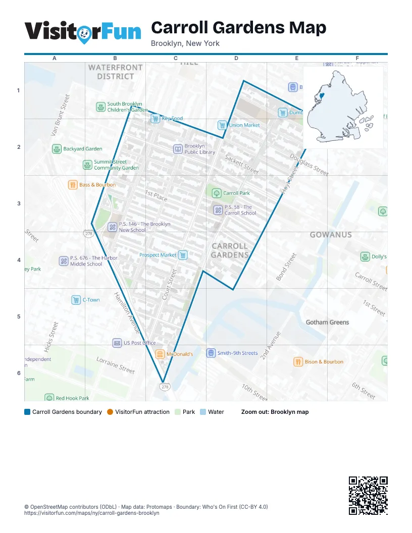
Street index of Carroll Gardens
Each street on the sheet and the grid squares it crosses.
- Baltic StreetD1
- Butler StreetD1
- Kane StreetD1
- Carroll StreetB2, C3, D3
- President StreetB2, D3, E3
- Sackett StreetB2, D2, E3
- Union StreetB2, D2, E3
- Douglass StreetD2
- Degraw StreetE2
- Hoyt StreetE2, E3
- 1st PlaceB3, C3, D3
- 2nd PlaceB3, C3, D4
- 3rd PlaceB3, C4
- Brooklyn-Queens ExpresswayB3, B4, B5
- Hamilton AvenueB3, B4, B5, C6
- Henry StreetB3, B4
- Hicks StreetB3
- Rapelye StreetB3
- Summit StreetB3
- Woodhull StreetB3
- Clinton StreetC3, B5
- Court StreetC3, C5
- 2nd StreetD3
- Smith StreetD3, D4, C6
- 4th PlaceB4, C4
- Coles StreetB4
- Luquer StreetB4, C4
- Nelson StreetB4, C5
- 5th StreetC4
- 3rd StreetD4
- 4th StreetD4
- Garnet StreetB5, C5
- Gowanus ExpresswayB5, C6
- Gowanus Expressway (HOV)B5
- Huntington StreetB5, C5
- Mill StreetB5
- West 9th StreetB5, C5
- 9th StreetC5
- Bush StreetC6
- Centre StreetC6
Places on the map
- BP
- Brooklyn Public Library
- Carroll Gardens Plumbing Supply
- Carroll Park
- Carroll Park Athletic Field
- Carroll Street (F,G)
- Cobble Hill Cinemas
- Cobble Hill High School of American Studies
- CVS Pharmacy
- DiMattina Playground Dog Run
- Dumbo Market
- F. G. Guido Funeral Home
- Key Food
- McDonald's
- New York Kids Club
- New York Police Department 76th Precinct
- Other Half Brewery
- P.S. 146 - The Brooklyn New School
- P.S. 58 - The Carroll School
- Prospect Market
- Saint Paul's Episcopal Church of Brooklyn
- Transit Garden
Next to Carroll Gardens
- Columbia Street Waterfront District map
- Gotham Greens
- Gowanus map
© OpenStreetMap contributors (ODbL) · Map data: Protomaps · Boundary: Who's On First (CC-BY 4.0)