

New York map
Central Harlem map
A printable two-page map of Central Harlem (Manhattan, New York), drawn by VisitorFun from OpenStreetMap. Page two is the street index: every street on the sheet with its grid square, the same list as below.
Open the map (PDF, US Letter)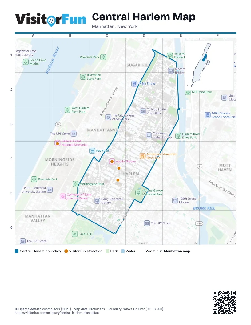
Street index of Central Harlem
Each street on the sheet and the grid squares it crosses.
- Bradhurst AvenueD1, D2
- Edgecombe AvenueD1, D2, C3
- Frederick Douglass BoulevardD1, E1, D2, C3, C4, C5, B6
- Harlem River DrivewayD1
- Macombs PlaceD1, E1, D2
- Saint Nicholas PlaceD1
- West 150th StreetD1, D2, E2
- West 151st StreetD1, D2, E2
- West 152nd StreetD1, E1
- West 153rd StreetD1, E1
- West 154th StreetD1, E1
- West 155th StreetD1, E1
- West 155th Street (surface)D1, E1
- Adam Clayton Powell Jr. BoulevardE1, D2, E2, D3, C4, D4, C5, C6
- Harlem River DriveE1, E2, E3
- Macombs Dam BridgeE1
- West 141st StreetD2, D3, E3
- West 142nd StreetD2, D3, E3
- West 143rd StreetD2, D3, E3
- West 144th StreetD2, E2, E3
- West 145th StreetD2, E2
- West 146th StreetD2, E2
- West 147th StreetD2, E2
- West 148th StreetD2, E2
- West 149th StreetD2, E2
- 145th Street BridgeE2, E3
- Malcolm X BoulevardE2, D3, E3, D4, C5, D5, C6
- Saint Nicholas AvenueC3, C4, C5, C6
- West 131st StreetC3, C4, D4
- West 132nd StreetC3, D3, D4
- West 133rd StreetC3, D3, D4
- West 134th StreetC3, D3, D4
- West 135th StreetC3, D3, D4, E4
- West 136th StreetD3, E4
- West 137th StreetD3, E3
- West 138th StreetD3, E3
- West 139th StreetD3, E3
- West 140th StreetD3
- 5th AvenueE3, D4, D5, C6
- Chisum PlaceE3
- East 138th StreetE3
- West 120th StreetB4, C4, C5, D5
- Hancock PlaceC4
- Manhattan AvenueC4, B5
- West 122nd StreetC4, C5, D5
- West 123rd StreetC4, C5, D5
- West 124th StreetC4, D5
- West 125th StreetC4, D5
- West 126th StreetC4
- West 127th StreetC4, D4
- West 128th StreetC4, D4
- West 129th StreetC4, D4
- Lenox Terrace PlaceD4
- West 130th StreetD4
- Morningside AvenueB5
- West 111th StreetB5, C6
- West 112th StreetB5, C6
- West 113th StreetB5, C6
- West 114th StreetB5, C5, C6
- West 115th StreetB5, C5, C6
- West 116th StreetB5, C5
- West 117th StreetB5, C5
- West 118th StreetB5, C5
- West 119th StreetC5
- West 121st StreetC5, D5
- East 120th StreetD5
- East 124th StreetD5
- East 125th StreetD5
- Madison AvenueD5
- Mount Morris Park WestD5
- Central Park NorthB6
- Central Park WestB6
- Frederick Douglass CircleB6
- West 110th StreetB6
- Duke Ellington CircleC6
- East 111th StreetC6
- East 112th StreetC6
Things to do on the Central Harlem map
Places on the map
- 1 Stop Shop Furniture
- 110 St–Malcolm X Plaza
- 110th St–Malcolm X Plaza
- 110th Street
- 116th Street
- 121 Lenox Gourmet Deli
- 125th Street
- 132nd Street Block Association Park
- 133rd Swing Street Garden
- 135th Street
- 145 Food Plaza
- 145th Street
- 148 Deli Grocery
- 148th Street Block Association Park
- 2166 Discount Store
- 304 Mini Mart Corp
- 527 Convenience store
- 5th Avenue & 116th Street
- 5th Avenue & West 118th Street
- 5th Avenue & West 120th Street
- 5th Avenue & West 125th Street
- 5th Avenue & West 128th Street
- 5th Avenue & West 130th Street
- 5th Avenue & West 132nd Street
- 5th Avenue & West 137th Street
- 5th Avenue Property & Parking LLC
- 67 Orange Street
- 787 Coffee
- 7th Avenue Deli Grocery
- 7th Heaven Pizza
- A Philip Randolph Square
- A Taste of Seafood
- A. Phillip Randolph Houses
- A.M.E. Metropolitan Church
- A&H Organic Choice
- A&S Deli
- Abyssinia
- Abyssinian Baptist Church
- Abyssinian Tot Lot
- Acts III Bagels
Next to Central Harlem
- Hamilton Heights map
- Manhattan Valley
- Manhattanville map
- Morningside Heights map
- Mott Haven map
- Sugar Hill
© OpenStreetMap contributors (ODbL) · Map data: Protomaps · Boundary: Who's On First (CC-BY 4.0)