

New York map
College Point map
A printable two-page map of College Point (Queens, New York), drawn by VisitorFun from OpenStreetMap. Page two is the street index: every street on the sheet with its grid square, the same list as below.
Open the map (PDF, US Letter)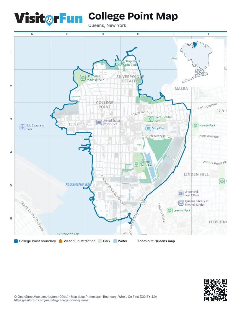
Street index of College Point
Each street on the sheet and the grid squares it crosses.
- 121st StreetC1, C2, C3, C4
- Capstan CourtC1
- Constitution PlaceC1
- Cove CourtC1
- Endeavor PlaceC1, C2
- Park CrescentC1, C2
- Powell Cove BoulevardC1, C2
- Riviera CourtC1
- Soundview LaneC1, C2
- 10th AvenueB2, C2, D2
- 115th StreetB2, B3
- 116th StreetB2, B3
- 117th StreetB2, C2, C3
- 9th AvenueB2, C2, D2
- Bay Park DriveB2
- Dalian CourtB2
- Poppenhusen AvenueB2, C2
- Taipei CourtB2
- 118th StreetC2, C3
- 119th StreetC2, C3, C4, C5
- 11th AvenueC2, E2, D3
- 120th StreetC2, C3, C4, C5
- 123rd StreetC2, C3, C4, C5, C6
- 124th StreetC2, C3, C4, C5, C6
- 125th StreetC2, C3, C4, C5, C6
- 5th AvenueC2, D2
- 6th AvenueC2, D2
- 7th AvenueC2, D2
- 8th AvenueC2
- 9th RoadC2
- College PlaceC2, C3
- College Point BoulevardC2, C3, C4, C5, D5, D6
- Keel CourtC2
- Ketch CourtC2
- Lax AvenueC2, D2
- Weatherly PlaceC2
- 126th StreetD2, C3, C4, C5, C6
- 127th StreetD2, D3, D4, D5
- 128th StreetD2, D3, D4
- 129th StreetD2, D3, D4
- 130th StreetD2, D3, D4
- Powells Cove BoulevardD2
- 138th PlaceE2
- 138th StreetE2, E3
- 110th StreetB3
- 111th StreetB3
- 112th StreetB3
- 113th StreetB3
- 114th StreetB3
- 14th AvenueB3, C3, D3, E3
- 14th RoadB3, C3, D3
- 15th AvenueB3, C3, D3, E3
- 12th AvenueC3
- 13th AvenueC3, E3
- 18th AvenueC3, D3
- Beech Court CircleC3
- Boker CourtC3
- 131st StreetD3, D4, D5, D6
- 132nd StreetD3, D4
- 133rd PlaceD3
- 135th StreetD3
- 136th StreetE3
- 137th StreetE3
- 139th StreetE3
- 140th StreetE3
- 141st StreetE3
- 142nd StreetE3
- 143rd PlaceE3
- 143rd StreetE3
- Petracca PlaceE3, E4
- Whitestone Expressway Service RoadE3, E4, D5, E5, D6
- 20th AvenueC4, D4, E4
- 21st AvenueC4
- 22nd AvenueC4, D4
- 23rd AvenueC4, D4
- 25th AvenueC4, D4, E4
- 25th RoadC4, D4, E4, D5
- Linden PlaceD4, D5
- Ulmer StreetD4, D5
- Whitestone ExpresswayE4, D5, E5, D6
- 122nd StreetC5
- 26th AvenueC5, D5
- 27th AvenueC5
- 28th AvenueC5, D5
- 29th AvenueC5
- 30th AvenueC5
- 31st AvenueC5, D5, D6
- Graham CourtC5
- 31st RoadC6
- Tallman BoulevardC6
- Van Wyck ExpresswayD6
Places on the map
- 110th Street & 14th Avenue
- 110th Street & 15th Avenue
- 127th Street & 11th Avenue
- 127th Street & 14th Avenue
- 127th Street & 15th Avenue
- 127th Street & 18th Avenue
- 127th Street & 20th Avenue
- 127th Street & 7th Avenue
- 131st Street & 15th Avenue
- 132nd Street & 20th Avenue
- 136th St Playground
- 14th Avenue & 115th Street
- 14th Avenue & 119th Street
- 14th Avenue & 123rd Street
- 14th Avenue & 128th Street
- 14th Avenue & 130th Street
- 14th Avenue & 132nd Street
- 14th Avenue & 135th Street
- 14th Avenue & 137th Street
- 14th Avenue & 139th Street
- 14th Avenue & 141st Street
- 14th Avenue & 142nd Street
- 14th Avenue & 143rd Street
- 14th Avenue & College Point Boulevard
- 15th Avenue & 117th Street
- 15th Avenue & 119th Street
- 15th Avenue & 124th Street
- 15th Avenue & 127th Street
- 15th Avenue & College Point Boulevard
- 20th Ave Deli
- 20th Avenue & 124th Street
- 20th Avenue & 127th Street
- 20th Avenue & 128th Street
- 20th Avenue & 131st Street
- 20th Avenue & College Point Boulevard
- 20th Avenue & Petracca Place
- 20th Avenue & Shopping Mall
- 20th Avenue & Shoprite
- 23rd Avenue & 129th Street
- 510Q future high school
Next to College Point
- Flushing map
- Linden Hill
- Malba
- Whitestone map
© OpenStreetMap contributors (ODbL) · Map data: Protomaps · Boundary: Who's On First (CC-BY 4.0)