

New York map
Queens map
A printable two-page map of Queens (Queens County, New York City, New York), drawn by VisitorFun from OpenStreetMap. Page two is the street index: every street on the sheet with its grid square, the same list as below.
Open the map (PDF, US Letter)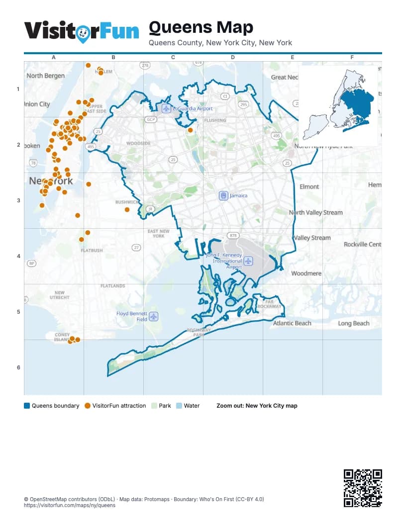
Street index of Queens
Each street on the sheet and the grid squares it crosses.
- 21st StreetB1, B2
- 29th StreetB1
- 31st StreetB1, B2
- 33rd StreetB1, B2
- 8th StreetB1
- Astoria BoulevardB1, C2
- Astoria Boulevard NorthB1, B2, C2
- Astoria Boulevard SouthB1, B2, C2
- Brooklyn-Queens Expressway WestB1, B2, C2
- Grand Central ParkwayB1, C1, B2, C2, D2, E2, C3, D3
- Hoyt Avenue NorthB1
- Hoyt Avenue SouthB1
- Robert F. Kennedy BridgeB1
- Vernon BoulevardB1, B2
- 94th StreetC1, C2
- College Point BoulevardC1, C2
- Linden PlaceC1, D2
- Van Wyck ExpresswayC1, C2, D2, D3, D4
- Whitestone ExpresswayC1, D1, C2
- Whitestone Expressway Service RoadC1, D1, C2
- 14th AvenueD1
- Bronx-Whitestone BridgeD1
- Clearview ExpresswayD1, D2, E2
- Clintonville StreetD1
- Cross Island ParkwayD1, E1, E2, E3
- Cross Island Parkway Service RoadD1
- Francis Lewis BoulevardD1, D2, E2, E3
- Throgs Neck BridgeD1
- Utopia ParkwayD1, D2
- 235th StreetE1
- Douglaston ParkwayE1, E2
- Little Neck ParkwayE1, E2
- Northern BoulevardE1, B2, C2, D2, E2
- 11th StreetB2
- 36th AvenueB2
- 39th StreetB2
- 41st AvenueB2
- 43rd AvenueB2
- 47th StreetB2, B3
- 48th StreetB2
- 49th StreetB2
- 51st AvenueB2
- 55th AvenueB2
- 56th RoadB2
- 57th PlaceB2
- 58th RoadB2
- 58th StreetB2
- 64th StreetB2
- Borden AvenueB2, C2
- BroadwayB2, C2, E5
- Brooklyn-Queens ExpresswayB2, C2
- Brooklyn-Queens Expressway EastB2, C2
- Crescent StreetB2
- Ed Koch Queensboro Bridge Lower LevelB2
- Ed Koch Queensboro Bridge Lower RoadwayB2
- Ed Koch Queensboro Bridge Upper LevelB2
- Flushing AvenueB2, B3
- Fresh Pond RoadB2, B3, C3
- Grand AvenueB2, C2, B3
- Greenpoint AvenueB2
- Jackson AvenueB2
- Laurel Hill BoulevardB2
- Long Island ExpresswayB2, C2, D2, E2
- Maspeth AvenueB2
- Maurice AvenueB2
- Pulaski BridgeB2
- Queens BoulevardB2, C2, C3, D3
- Queens Plaza SouthB2
- Queens-Midtown ExpresswayB2, C2
- Queens-Midtown TunnelB2
- Queensboro Bridge (Lower Level)B2
- Queensboro Bridge (Upper Level)B2
- Queensboro PlazaB2
- Review AvenueB2
- Roosevelt AvenueB2, C2, D2
- Roosevelt Island BridgeB2
- Rust StreetB2, B3
- Thomson AvenueB2
- Van Dam StreetB2
- 108th StreetC2
- 114th StreetC2
- 37th AvenueC2
- 62nd DriveC2
- 63rd AvenueC2
- 68th StreetC2
- 69th StreetC2, C3
- Apex PlaceC2
- Boody StreetC2
- Eliot AvenueC2
- Horace Harding ExpresswayC2, D2, E2
- Jewel AvenueC2
- Junction BoulevardC2
- Main StreetC2, D2, D3
- Park Drive EastC2
- Seaver WayC2
- Woodhaven BoulevardC2, C3
- 206th StreetD2
- 75th AvenueD2
- 85th RoadD2
- Kissena BoulevardD2
- Parsons BoulevardD2, D3
- Union TurnpikeD2, E2, C3, D3
- Utopia TurnpikeD2, D3
- 212th StreetE2, E3
- 93rd AvenueE2
- Braddock AvenueE2
- East Hampton BoulevardE2
- Fairway DriveE2
- Hewlett StreetE2
- Hillside AvenueE2, C3, D3
- Hollis Court BoulevardE2, E3
- Jamaica AvenueE2, C3, D3, E3
- Jericho TurnpikeE2
- Marcus AvenueE2
- Northern State ParkwayE2
- South Service RoadE2
- Springfield BoulevardE2, E3, E4
- West Alley RoadE2
- Winchester BoulevardE2
- 54th StreetB3
- 55th StreetB3
- Cooper AvenueB3, C3
- Cypress AvenueB3, C3
- Grand StreetB3
- Metropolitan AvenueB3, C3, D3
- Myrtle AvenueB3, C3, D3
- 117th StreetC3
- 73rd PlaceC3
- Atlantic AvenueC3, D3
- Central AvenueC3
- Cross Bay BoulevardC3, C4, D4, D5
- Cypress Hills StreetC3
- Eldert LaneC3
- Etna StreetC3
- Force Tube AvenueC3
- Forest Park DriveC3
- Highland BoulevardC3
- Highland PlaceC3
- Jackie Robinson ParkwayC3, D3
- Linden BoulevardC3, D3, E3, C4
- North Conduit AvenueC3, C4, D4, E4
- North Conduit BoulevardC3
- Ridgewood AvenueC3
- Rockaway BoulevardC3, D3, D4, E4
- South Conduit AvenueC3, C4, D4, E4
- 132nd StreetD3
- 138th StreetD3
- 150th StreetD3, D4
- 168th StreetD3
- 94th AvenueD3
- Baisley BoulevardD3
- Brinkerhoff AvenueD3
- Dunkirk StreetD3
- Farmers BoulevardD3, E3, D4
- Guy R. Brewer BoulevardD3, D4
- Lefferts BoulevardD3, D4
- Liberty AvenueD3
- Merrick BoulevardD3, E3
- Newburg StreetD3
- Sutphin BoulevardD3
- Van Wyck Expressway EastD3
- Van Wyck Expressway WestD3
- 114th RoadE3
- 115th AvenueE3
- Belt ParkwayE3, C4, D4, E4
- Hempstead AvenueE3
- Hempstead TurnpikeE3
- Southern State ParkwayE3
- Nassau ExpresswayC4, D4
- Shore Parkway SouthC4
- JFK Access RoadD4
- JFK ExpresswayD4
- North Boundary RoadD4
- Terminal 1 ArrivalsD4
- Terminal 1 DeparturesD4
- Sunrise HighwayE4
- Beach Channel DriveC5, D5, E5, C6
- Beach 35th StreetD5
- Cross Bay BridgeD5
- Cross Bay ParkwayD5
- Edgemere AvenueD5
- Rockaway Beach BoulevardD5
- Rockaway FreewayD5
- Seagirt BoulevardD5, E5
- Beach 9th StreetE5
- Cornaga AvenueE5
- Empire AvenueE5
- Mott AvenueE5
- Marine Parkway–Gil Hodges Memorial BridgeC6
Things to do on the Queens map
Places on the map
- 74th Street–Broadway
- AAL
- All Faiths Cemetery
- Allied Aviation Fuel
- Allied Aviation Tank Farm
- Aqueduct Racetrack
- Arverne East Nature Preserve
- Astoria Gas Turbines
- Astoria Generating Station
- Astoria Houses
- Astoria Park
- Baisley Park Houses
- Baisley Pond
- Bell Park Manor Terrace
- Belle Harbor
- Big Egg Marsh
- Big Six Towers
- Black Bank Marsh
- Black Wall
- Breezy Point
- Breezy Point Surf Club
- Breezy Point Tip
- Brookville Park
- Cedar Grove Cemetery
- Cemetery of the Evergreens
- Clearview Park
- Cohen’s Children’s Medical Center
- College Point Depot
- College Point Yacht Club
- Con Edison
- Corona Yard
- Court Square
- Court Square–23rd Street
- Creedmoor Psychiatric Center
- Crocheron Park
- Cunningham Park
- Cypress Hills Cemetery
- Douglaston Golf Course
- Dubos Point Wildlife Sanctuary
- East Pond
Maps inside Queens
- Alley Pond Park map
- Arverne map
- Astoria map
- Bayside map
- Bayswater map
- Belle Harbor map
- Bellerose map
- Briarwood map
- Cambria Heights map
- College Point map
- Cunningham Park map
- Cypres Hills map
- Douglaston map
- East Elmhurst map
- Edgemere map
- Elmhurst map
- Far Rockaway map
- Floral Park map
- Flushing map
- Forest Park map
- Fresh Meadows map
- Fresh Pond map
- Glen Oaks map
- Hollis map
- Hollis Hills map
- Howard Beach map
- Jackson Heights map
- Jamaica map
- Jamaica Estates map
- John F. Kennedy International Airport District map
- Kew Gardens map
- Kew Gardens Hills map
- LaGuardia Airport District map
- Laurelton map
- Little Neck map
- Long Island City map
- Maspeth map
- Middle Village map
- Neponsit map
- North Bayside map
- Ozone Park map
- Queens Village map
- Rego Park map
- Richmond Hill map
- Ridgewood map
- Rockaway Beach map
- Rockaway Park map
- Rockaway Point map
- Rosedale map
- South Corona map
- South Ozone Park map
- Springfield Gardens map
- St. Albans map
- Sunnyside map
- Terrace Heights map
- Whitestone map
- Woodhaven map
- Woodside map
Next to Queens
- Albertson
- Atlantic Beach
- Bushwick map
- Cedarhurst
- Coney Island map
- East New York map
- Elmont
- Flatbush map
- Flatlands map
- Franklin Square
- Garden City Park
- Great Neck
- Greenvale
- Guttenberg
- Harlem
- Hewlett
- Hoboken
- Inwood map
- Long Beach map
- Lynbrook
- Manhasset
- Midtown
- New Utrecht
- New York
- North Bergen
- North New Hyde Park
- North Valley Stream
- Rockville Centre
- Roslyn Heights
- Saddle Rock
- South Valley Stream
- Union City
- Upper East Side map
- Valley Stream
- West Hempstead
- Williamsburg map
- Woodmere
© OpenStreetMap contributors (ODbL) · Map data: Protomaps · Boundary: Who's On First (CC-BY 4.0)