

New York map
Douglaston map
A printable two-page map of Douglaston (Queens, New York), drawn by VisitorFun from OpenStreetMap. Page two is the street index: every street on the sheet with its grid square, the same list as below.
Open the map (PDF, US Letter)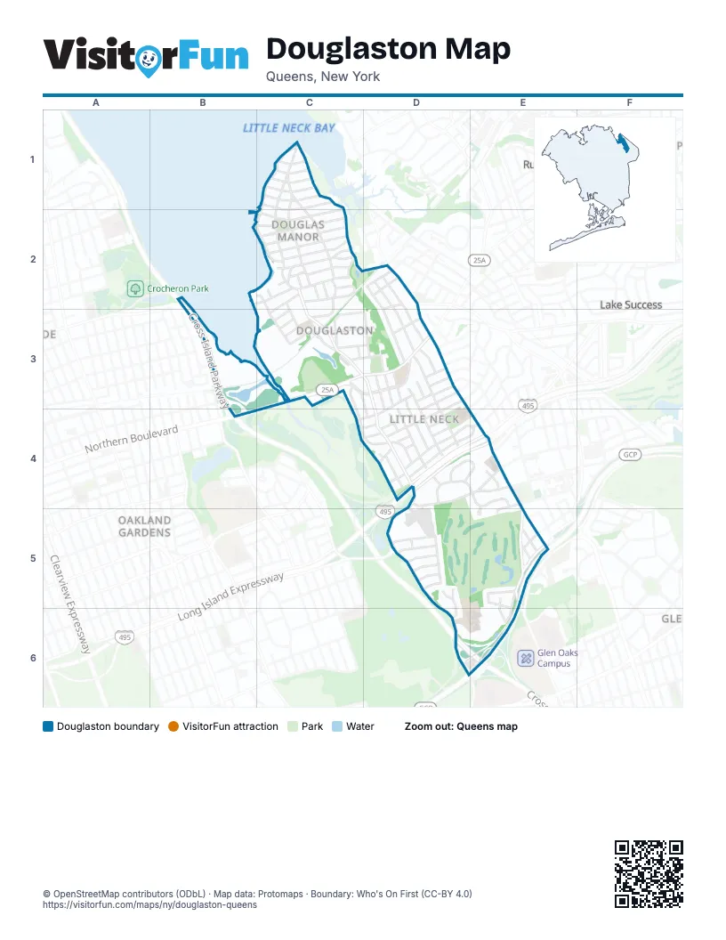
Street index of Douglaston
Each street on the sheet and the grid squares it crosses.
- Bayview AvenueC1
- Beverly RoadC1, C2
- Center DriveC1, C2
- Douglas RoadC1, C2
- East DriveC1, C2
- Grosvenor StreetC1
- Kenmore RoadC1
- Knollwood AvenueC1
- Marinette StreetC1
- Richmond RoadC1
- Shore RoadC1, C2
- Warwick AvenueC1
- West DriveC1, C2
- 233rd StreetB2, C2, C3
- 38th RoadB2, C2
- Cross Island ParkwayB2, B3, B4, D6, E6
- 233rd PlaceC2
- 234th StreetC2, C3
- 235th StreetC2, C3
- 239th StreetC2
- 240th StreetC2, C3, D4, D5
- 38th AvenueC2
- 38th DriveC2, C3
- Alston PlaceC2
- Ardsley RoadC2
- Arleigh RoadC2
- Bay StreetC2
- Cedar LaneC2
- Cherry StreetC2
- Clark LaneC2
- Forest RoadC2
- Hillcrest AvenueC2
- Hollywood AvenueC2
- Manor RoadC2
- Meknight DriveC2
- Oak LaneC2
- Park LaneC2
- Ridge RoadC2
- Sandhill RoadC2, D2
- Stuart LaneC2, C3
- Westmoreland PlaceC2
- Willow PlaceC2, C3
- 247th StreetD2, D3, E5
- 248th StreetD2, D3, D4
- 249th StreetD2, D3
- 39th AvenueD2, C3
- 40th AvenueD2, C3
- 41st AvenueD2, C3
- 41st DriveD2
- Depew AvenueD2, C3
- Little Neck ParkwayD2
- 241st StreetC3, D4
- 39th RoadC3
- Alameda AvenueC3, D3
- Church StreetC3, D3
- Douglaston ParkwayC3, D3, D4, D5, D6
- Hamilton PlaceC3
- Hanford StreetC3, C4, D4
- Northern BoulevardC3, D3, B4
- Pine StreetC3, D3
- Poplar StreetC3, D3
- Prospect AvenueC3
- Willow StreetC3
- 243rd StreetD3, D4, E5
- 244th StreetD3, D4, D5, E5, D6, E6
- 245th StreetD3, D4
- 43rd AvenueD3
- Beechknoll AvenueD3
- Cambria AvenueD3, D4
- Deepdale AvenueD3
- Marathon ParkwayD3, E4, E5
- Orient AvenueD3
- Overbrook StreetD3, D4
- Rushmore AvenueD3, C4, D4
- Rushmore TerraceD3
- Thebes AvenueD3
- Zion StreetD3
- Carolina RoadC4, D4
- 240th PlaceD4
- 246th CrescentD4, E4
- 51st AvenueD4
- 52nd AvenueD4
- 53rd AvenueD4
- 54th AvenueD4, E4
- 57th DriveD4, E4
- 61st AvenueD4, E4
- Barrows CourtD4
- Horace Harding ExpresswayD4, E4
- Long Island ExpresswayD4, E4
- Maryland RoadD4
- Redfield StreetD4
- Thornhill AvenueD4, E4
- Van Zandt AvenueD4
- 245th PlaceE4
- 246th PlaceE4
- 60th AvenueE4
- 62nd AvenueE4, E5
- 63rd AvenueE4, E5
- 242nd StreetD5
- 65th AvenueD5
- 66th AvenueD5
- 67th AvenueD5
- 68th AvenueD5
- 69th AvenueD5
- 70th AvenueD5
- 246th StreetE5
- 64th AvenueE5
- 72nd AvenueE5
- 73rd AvenueE5, E6
- Commonwealth BoulevardE5
- Cullman AvenueE5
- Grand Central ParkwayE5, E6
- Oak Park DriveD6, E6
Places on the map
- 40th Avenue & Little Neck Parkway
- 41st Avenue & Little Neck Parkway
- Aegea West Gyros & Pizza
- Alameda Malls
- Alley Pond Golf Center
- Aurora Pond
- Back Tees
- BMW of Bayside (Douglaston Campus)
- BP
- Cathedral Seminary House of Formation
- Catherine Turner Richardson Park
- Community Church of Douglaston
- CVS Pharmacy
- Divine Wisdom Catholic Academy
- Dog
- Douglaston
- Douglaston Club
- Douglaston Golf Course
- Douglaston Parkway & 61st Avenue
- Douglaston Parkway & 65th Avenue
- Douglaston Plaza Shopping Center
- Douglaston Shopping Center Bus Stop
- Douglaston Towne House Condominium
- Dunkin' Donuts
- FDNY Engine 313/Ladder 164
- Food Bazaar
- Green Side Bunker
- Greenside Bunker
- Horace Harding Expressway & Marathon Parkway
- John Riedl Wildflower Meadow
- Joseph B. Hellman Overlook
- Louis Pasteur Park
- M.S. 67Q - Louis Pasteur Middle School
- Middle Tees
- North Hills Branch Queens Borough Public Library
- Northern Boulevard & 227th Street
- Northern Boulevard & 230th Street
- Northern Boulevard & 243rd Street
- Northern Boulevard & 244th Street
- Northern Boulevard & 248th Street
Next to Douglaston
- Lake Success
- Oakland Gardens
- Russell Gardens
- Russell Woods
- University Gardens
© OpenStreetMap contributors (ODbL) · Map data: Protomaps · Boundary: Who's On First (CC-BY 4.0)