

New York map
DUMBO map
A printable two-page map of DUMBO (Brooklyn, New York), drawn by VisitorFun from OpenStreetMap. Page two is the street index: every street on the sheet with its grid square, the same list as below.
Open the map (PDF, US Letter)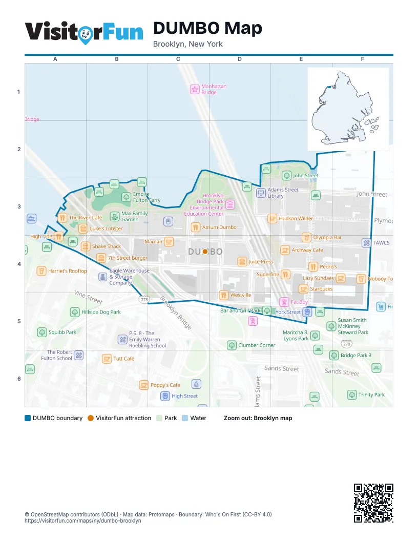
Street index of DUMBO
Each street on the sheet and the grid squares it crosses.
- Dock StreetB3, B4
- Water StreetB3, A4, C4, D4, E4
- Main StreetC3, C4
- Plymouth StreetC3, D3, F3
- Adams StreetD3, D4
- John StreetD3, E3, F3
- Washington StreetD3, D4, D5
- Jay StreetE3, E4, E5
- Pearl StreetE3, E4, E5
- Bridge StreetF3, F5
- Old Fulton StreetA4, B4, B5
- Brooklyn BridgeB4, C4, C5
- Front StreetB4, C4, D4, E4
- Howard AlleyC4
- York StreetC4, C5, D5, E5, F5
- Brooklyn-Queens ExpresswayC5
Things to do on the DUMBO map
Places on the map
- 2nd STREET
- 68 Jay Street Bar
- 7 Old Fulton
- 7th Street Burger
- Adams Street Library
- Al Mar
- Almondine Bakery
- Alo
- Aloha Alley
- Anchorage Plaza
- APC DUMBO
- Archway Cafe
- Atrium Dumbo
- Aveda Arts and Sciences Institute New York
- Bar and Grill Park
- Barber on Pearl
- Beepublic
- Berl's Brooklyn Poetry Shop
- Birbante
- BLANC et ROUGE
- Bridge Fresh
- Bridgestone Dry Cleaners & Laundry
- Bright Horizons
- Brookland Ferry Landing
- Brooklyn Bridge Park Environmental Education Center
- Brooklyn Bridge Viewpoint
- Brooklyn Flea
- Brooklyn Gifts
- Brooklyn Historical Society
- Brooklyn Property Clerk
- Burrow
- Butler
- Carousel Bioswale
- Cecconi’s Dumbo
- Celestine
- Chabad of Dumbo
- Chase
- Citi Bike - Bridge St & Front St
- Citi Bike - Dock St & Front St
- Citi Bike - Front St & Jay St
© OpenStreetMap contributors (ODbL) · Map data: Protomaps · Boundary: Who's On First (CC-BY 4.0)