

New York map
East Flatbush map
A printable two-page map of East Flatbush (Brooklyn, New York), drawn by VisitorFun from OpenStreetMap. Page two is the street index: every street on the sheet with its grid square, the same list as below.
Open the map (PDF, US Letter)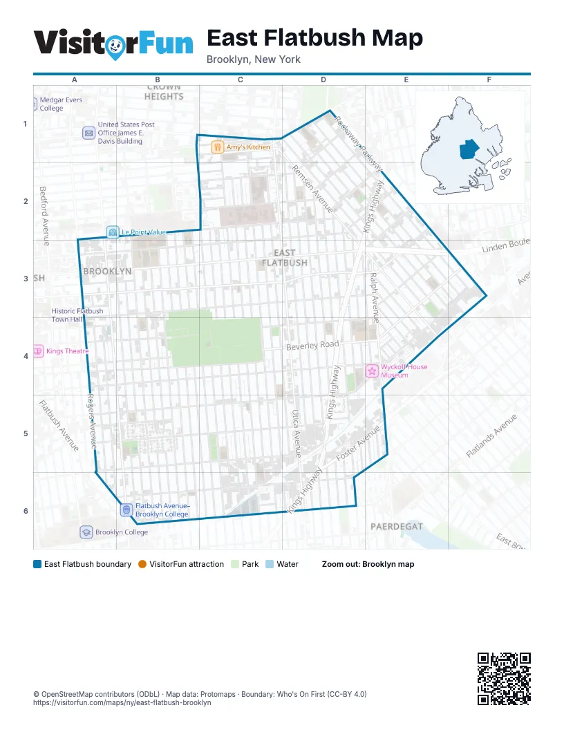
Street index of East Flatbush
Each street on the sheet and the grid squares it crosses.
- East 48th StreetC1, C2, C3, C4, C5, D6
- East New York AvenueC1, D1
- Empire BoulevardC1
- Lefferts AvenueC1
- Maple StreetC1
- Remsen AvenueC1, D1, D2, E3, E4
- Schenectady AvenueC1, C2, C3, C4, C5, C6
- Troy AvenueC1, C2, C3, C4, C5, C6
- Utica AvenueC1, C2, D3, D4, D5, D6
- East 51st StreetD1, D2, D3, D4, D5, D6
- East 92nd StreetD1, D2, E2, E3, F4
- East 93rd StreetD1, E2, E3, F3
- East 94th StreetD1, E2, E3, F3
- East 95th StreetD1, E2, E3, F3
- East 96th StreetD1, E2, E3, F3
- Montgomery StreetD1
- Rutland RoadD1, C2, D2
- Winthrop StreetD1, C2, D2
- Clarkson AvenueA2, B2, C2, D2, E2
- East 37th StreetB2, B3, B4, B5, B6
- East 38th StreetB2, B3, B4, B5, B6
- East 39th StreetB2, B3, B4, C5, C6
- East 40th StreetB2, B3, C4, C5, C6
- New York AvenueB2, B3, B4, B5
- Albany AvenueC2, C3, C4, C5, C6
- East 42nd StreetC2, C3, C4, C5, C6
- East 43rd StreetC2, C3, C4, C5, C6
- East 45th StreetC2, C3, C4, C5, C6
- East 46th StreetC2, C3, C4, C5, C6
- East 49th StreetC2, C3, C4, D4, D5, D6
- Fenimore StreetC2
- Hawthorne StreetC2
- Lenox RoadC2, D2, E2, A3, B3, C3
- Midwood StreetC2
- East 52nd StreetD2, D4, D5, D6
- East 53rd StreetD2, D3, D4, D5, D6
- East 54th StreetD2, D3, D4, D5, D6
- East 55th StreetD2, D4, D5
- East 56th StreetD2, D3, D4, D5, D6
- East 57th StreetD2, D3, D4, D5
- East 58th StreetD2, D3, D4, E5
- East 91st StreetD2, E2, E3, E4
- Kings HighwayD2, E2, D3, D4, D5, D6
- Church AvenueE2, A3, B3, C3, D3, E3
- Rockaway ParkwayE2, F3
- Willmohr StreetE2, E3
- Erasmus StreetA3
- Linden BoulevardA3, B3, C3, D3, E3, F3
- Lloyd StreetA3
- Martense StreetA3, B3
- Nostrand AvenueA3, A4, B5, B6
- Snyder AvenueA3, B3, C3, D3, E3
- Brooklyn AvenueB3, B4, B5
- East 31st StreetB3, B4, B5, B6
- East 32nd StreetB3, B4, B5, B6
- East 34th StreetB3, B4, B5, B6
- East 35th StreetB3, B4, B5, B6
- Fairview PlaceB3
- Raleigh PlaceB3
- East 59th StreetD3, E3, E4, E5
- Avenue AE3
- Avenue BE3, F3, E4
- East 87th StreetE3, E4
- East 88th StreetE3, E4
- East 89th StreetE3, E4
- Ralph AvenueE3, E4
- Ditmas AvenueF3, D4, E4
- Albemarle RoadA4
- Beverley RoadA4, B4, C4, D4, E4
- Clarendon RoadA4, C4, D4, E4
- Cortelyou RoadA4, B4, C4
- East 28th StreetA4, A5, A6
- East 29th StreetA4, A5, A6
- Rogers AvenueA4
- Tilden AvenueA4, B4, C4, D4, E4
- Canarsie LaneC4, E4
- Avenue DD4, A5, B5, C5, D5
- Branton StreetE4
- Coventry RoadE4
- Dorset StreetE4
- East 83rd StreetE4
- East 86th StreetE4
- Farragut RoadA5, C5, D5
- Foster AvenueA5, B5, C5, D5, E5
- Newkirk AvenueA5, B5
- Brooklyn RoadB5
- Farragut PlaceB5
- Victor RoadB5
- Jodie CourtD5
- Preston CourtD5, E5
- Whitty LaneD5
- Kingsway PlaceE5
- Flatbush AvenueA6, B6
- Glenwood RoadA6, C6, D6
- Avenue HB6, C6
- Glendale CourtC6
Places on the map
- "diner"
- 10 Minute Oil Change
- 99¢ NY City
- 99¢ World
- Achievement First Crown Heights Elementary / Middle School
- Ada Washer Repairs
- Adam Deli Grocery
- ADT Security Services, LLC
- African Queen Boutique
- Agape Christian Fellowship
- Alabama Avenue & Hawthorne Street
- Albany Avenue & Clarkson Avenue
- Albany Avenue & Maple Street
- Albany Avenue & Rutland Road
- Albany Avenue & Winthrop Street
- All Saints Pentecostal Church
- Amoco
- Amy's Kitchen
- Apostolic House of Prayer
- Apostolic United Holiness Church
- Assembly of the First Born
- Associated Supermarket
- Avenue B & East 87th Street
- Avenue B & Ralph Avenue
- Avenue B & Remsen Avenue
- Avenue D & Brooklyn Avenue
- Avenue D & East 31st Street
- Avenue D & East 35th Street
- Avenue D & East 37th Street
- Avenue D & East 38th Street
- Avenue D & East 39th Street
- Avenue D & East 40th Street
- Avenue D & East 42nd Street
- Avenue D & East 43rd Street
- Avenue D & East 45th Street
- Avenue D & East 46th Street
- Avenue D & East 48th Street
- Avenue D & East 52nd Street
- Avenue D & East 53rd Street
- Avenue D & Kings Highway
Next to East Flatbush
- Brownsville map
- Crown Heights map
- Paerdegat
© OpenStreetMap contributors (ODbL) · Map data: Protomaps · Boundary: Who's On First (CC-BY 4.0)