

New York map
Eltingville map
A printable two-page map of Eltingville (Staten Island, New York), drawn by VisitorFun from OpenStreetMap. Page two is the street index: every street on the sheet with its grid square, the same list as below.
Open the map (PDF, US Letter)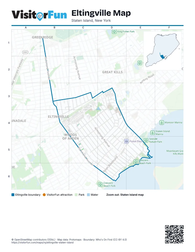
Street index of Eltingville
Each street on the sheet and the grid squares it crosses.
- Bartlett AvenueB3
- Eltingville BoulevardB3, B4
- Getz AvenueB3
- Gil CourtB3, C3
- Lamoka AvenueB3, C3
- Laredo AvenueB3
- Maria LaneB3
- Memphis AvenueB3
- Richmond AvenueB3, B4, C5, C6, D6
- Ridgewood AvenueB3, C4
- Abingdon AvenueC3
- Acacia AvenueC3, D4
- Amboy RoadC3, D3, B4, C4
- Armstrong AvenueC3, C4, D5, E6
- Coco CourtC3, C4
- Cortelyou AvenueC3
- Demopolis AvenueC3
- Escanaba AvenueC3
- Fern AvenueC3
- Notre Dame AvenueC3
- Old Amboy RoadC3, C4
- Wilson AvenueC3, B4, C4
- Beth PlaceD3
- Brower CourtD3
- Colon AvenueD3
- Giffords GlenD3
- Hillcrest AvenueD3, D4
- Holly AvenueD3, D4
- Lindenwood PlaceD3
- Lindenwood RoadD3, D4
- Montvale PlaceD3
- Nelson AvenueD3, D4, E4
- Nolan AvenueD3
- Oakdale StreetD3, C4, D4
- Park TerraceD3
- Pleasant StreetD3
- Saccheri CourtD3
- Scarsdale StreetD3
- School StreetD3
- Seeley LaneD3
- Sherwood PlaceD3
- Coryn CourtB4
- Lyndale LaneB4
- Mosely AvenueB4
- Putnam StreetB4
- Ridgecrest AvenueB4, C4, C5, D6
- Saint Albans PlaceB4, C4
- Beach RoadC4, D5
- Cloverdale AvenueC4, D4
- Elmwood AvenueC4, D4
- Pacific AvenueC4, C5, D5
- Ramblewood AvenueC4, D4
- Robinson AvenueC4, D5, E6
- Sycamore StreetC4, D4, C5
- Thornycroft AvenueC4, C5, D5, D6
- Winchester AvenueC4, C5, D6
- Bennington StreetD4, C5, D5
- David StreetD4, D5
- Driggs StreetD4, E4, D5
- Edgewood RoadD4
- Eleanor LaneD4
- Highmount RoadD4
- Hillcrest StreetD4, C5, D5
- Hilltop PlaceD4
- Monticello TerraceD4
- Nash CourtD4
- Oceanview PlaceD4, D5
- Osborn AvenueD4, D5
- Wiman AvenueD4, E4, E5
- Florence StreetE4
- Presley StreetE4
- Russell StreetE4, D5
- Crest LoopC5
- Hilltop RoadC5, C6
- Koch BoulevardC5
- Park RoadC5
- Shirley AvenueC5
- Glover StreetD5, E5
- Groton StreetD5, D6
- Heinz AvenueD5, E5
- Hylan BoulevardD5, E5, D6
- King StreetD5, C6
- Lillian PlaceD5
- Littlefield AvenueD5, D6
- Walnut AvenueD5, E5
- William AvenueD5
- Crispi LaneE5
- Dockside LaneE5
- Filipe LaneE5
- Goodall StreetE5
- Harbour CourtE5
- Highland LaneE5
- Perona LaneE5
- Point StreetE5
- Sweetwater AvenueE5
- Tennyson DriveE5, D6, E6
- Oceanic AvenueD6
- Prol PlaceD6
- Seacrest AvenueD6
Places on the map
- Armstrong Gardens Owners Corporation
- Avon at Great Kills Apartments
- Cavalry Assembly of God
- Church of Saint Clare
- Crescent Beach Park
- Eltingville
- Eltingville Commons
- Eltingville Post Office
- Eltingville Shopping Center
- FDNY Battalion 23/Engine 162/Ladder 82
- Kung Eye
- Memorial Garden
- Mobil
- P.S. 8 - The Shirlee Solomon Great Kills School
- Pastosa Ravioli
- Postal Plaza
- Sailors Keys
- Saint Clare's School
- Stop & Shop
- The Rabbi Jacob Joseph School Boys School
- Top Tomato Superstore
- Wavecrest Condominium
- Wood Duck Pond Bluebelt
- YMCA South Shore Branch
Next to Eltingville
- Annadale
- Bay Terrace
- Great Kills map
- Greenridge
© OpenStreetMap contributors (ODbL) · Map data: Protomaps · Boundary: Who's On First (CC-BY 4.0)