

New York map
Great Kills map
A printable two-page map of Great Kills (Staten Island, New York), drawn by VisitorFun from OpenStreetMap. Page two is the street index: every street on the sheet with its grid square, the same list as below.
Open the map (PDF, US Letter)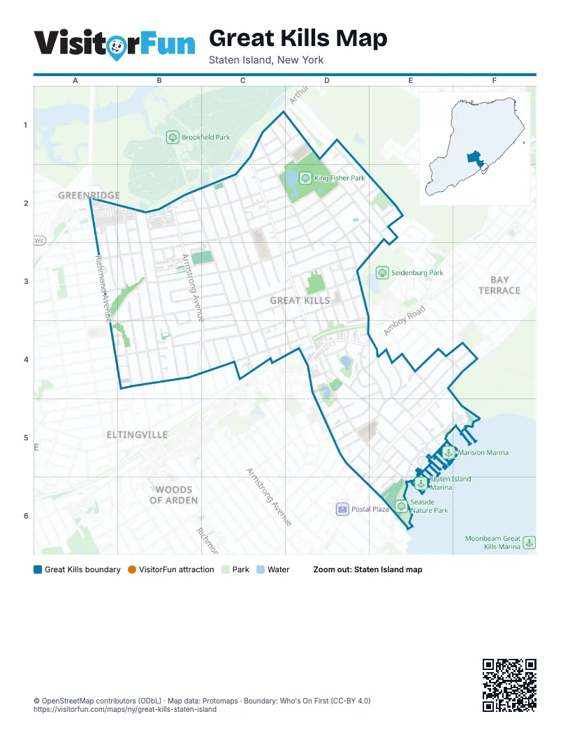
Street index of Great Kills
Each street on the sheet and the grid squares it crosses.
- Arthur Kill RoadC1, A2, B2, C2
- Cromer StreetC1
- Daleham StreetC1, D1
- Elkhart StreetC1, D1, C2
- Giffords LaneC1, C2, D3, D4
- Greaves AvenueC1, D1, D2, D3, E4
- Miles AvenueC1, C2, D2, D3, D4
- Troy StreetC1, D1
- Corbin AvenueD1, D2, E2
- Country Woods LaneD1, D2
- Fairfield StreetD1, C2, D2
- Nutwood CourtD1
- Tanglewood DriveD1, D2
- Teakwood CourtD1
- Bartlett AvenueA2, A3, B4
- Eltingville BoulevardA2, B3, B4
- Abbey RoadB2
- Abingdon CourtB2
- Armstrong AvenueB2, B4, C4
- Cortelyou AvenueB2, B3, B4
- East Brandis AvenueB2
- East Macon AvenueB2, C2
- Getz AvenueB2, B3, B4
- Gurley AvenueB2, C2
- Lennon CourtB2
- Opp CourtB2
- Ridgewood AvenueB2, B4
- Arkansas AvenueC2
- Barlow AvenueC2, D2, A3, B3
- Barlow CourtC2, B3, C3
- Brookfield AvenueC2, C3, C4
- Colon AvenueC2, C3, C4
- Doane AvenueC2, C3
- Dorit CourtC2
- Elverton AvenueC2, C3
- Eric LaneC2
- Hereford StreetC2, D2
- Islington StreetC2, D2
- Jumel StreetC2, D2
- Lexington LaneC2
- Michael CourtC2
- Pemberton AvenueC2
- Stieg AvenueC2, C3
- Theresa LaneC2
- Cottonwood CourtD2, E2
- Dunbar StreetD2, E3
- Ironwood StreetD2
- Kennington StreetD2
- Leverett AvenueD2, B3, C3, D3
- Leverett CourtD2, D3
- Linton PlaceD2, D3
- Nahant StreetD2, D3
- Sandalwood DriveD2, E2
- Tudor StreetD2, E3
- Cherrywood CourtE2
- Dewey AvenueE2, C3, D3, E3
- Willowwood LaneE2
- Genesee AvenueA3, B3, C3, A4, B4
- Sweet Brook RoadA3, B3, A4
- East Perkiomen AvenueB3
- East Reading AvenueB3, C3
- East Scranton AvenueB3, C3
- East Stroud AvenueB3, C3
- Fenway CircleB3
- Middle Loop RoadB3
- Stanley CircleB3, B4
- Abingdon AvenueC3
- Blaise CourtC3
- East Augusta AvenueC3
- North Rhett AvenueC3, D4
- Woodland AvenueC3, D3
- Dewey PlaceD3
- Exeter StreetD3
- Gibson AvenueD3
- Greaves CourtD3
- Greaves LaneD3
- Howton AvenueD3
- Katan AvenueD3, B4, C4, D4
- Lamoka AvenueD3, B4, C4, D4
- Rhett AvenueD3, D4
- Sampson AvenueD3, D4
- Schley AvenueD3, D4
- Shafter AvenueD3
- Demopolis AvenueB4
- East Figurea AvenueB4, C4
- Escanaba AvenueB4, C4
- Frank CourtB4
- Gabriele CourtB4
- Ovas CourtB4
- Patty CourtB4
- Richmond AvenueB4
- Star CourtB4
- Baltimore StreetC4, D4
- Fern AvenueC4
- Lindenwood RoadC4
- Margaret StreetC4, D4
- Notre Dame AvenueC4
- Wilson AvenueC4
- Adrienne PlaceD4
- Amboy RoadD4, E4
- Brower CourtD4
- Brown AvenueD4
- Cleveland AvenueD4, D5, E5, E6
- Clinton RoadD4
- Clovis RoadD4
- Dent RoadD4, E4
- Giffords GlenD4
- Hardy PlaceD4
- Hillside TerraceD4, D5, E5
- Locust PlaceD4
- Midland RoadD4, E4, E5
- Nelson AvenueD4, D5, D6, E6
- Oak CourtD4
- Ramble RoadD4, E4
- Stonecrest CourtD4
- Durant AvenueE4, D5, E5
- Fieldway AvenueE4
- Great Kills RoadE4, E5
- Greencroft AvenueE4, F4, E5
- Highland RoadE4
- Hylan BoulevardE4, F4, D5, E5, D6
- King James CourtE4
- Maybury AvenueE4, E5
- O'Gorman AvenueE4
- Ocean RoadE4, E5
- Rustic PlaceE4, D5
- Trent StreetE4
- Keegans LaneF4
- Belden StreetD5
- David StreetD5
- Florence StreetD5
- Grandview TerraceD5, E5
- Monticello TerraceD5
- Nash CourtD5
- Tarlee PlaceD5, E5
- Ackerman StreetE5, E6
- Coral CourtE5
- Cornish StreetE5
- Cottage AvenueE5
- Hartford StreetE5, E6
- Mansion AvenueE5, F5, E6
- McKee AvenueE5
- Melrose PlaceE5
- Mercer PlaceE5
- Waterside ParkwayE5
- Whitman AvenueE5
- Fairlawn AvenueF5
- Osprey CourtF5
- Crispi LaneE6
- Fitzgerald AvenueE6
- Morris PlaceE6
- Sweetwater AvenueE6
- Tennyson DriveE6
Places on the map
- Aldi
- Armstrong Gardens Condominium
- Atrium Mall
- Barlow Court Condominiums
- Christ Lutheran Church
- Cobble Hill Walk
- Dove Diner
- Getz Plaza
- Great Kills
- Great Kills High School
- Great Kills Little League Inc.
- Great Kills Moravian Church
- Great Kills Post Office
- Great Kills Swim Club
- Greenridge Shopping Plaza
- I.S. 24 - Myra S. Barnes Intermediate School
- Islington Pond
- Jack's Pond
- Jacks Pond Bluebelt
- King Fisher Park
- Mobil
- Oohra's Torah Spot
- P.S. 32 - The Giffords School
- P37R - The David Marquis School of the Arts
- Seaside Nature Park
- Sweet Brook Bluebelt
- The UPS Store
- Waters Edge
- Waterside Parkway
- Yacht Club Cove
Next to Great Kills
- Bay Terrace
- Eltingville map
- Greenridge
- Woods of Arden
© OpenStreetMap contributors (ODbL) · Map data: Protomaps · Boundary: Who's On First (CC-BY 4.0)