

New York map
Flatlands map
A printable two-page map of Flatlands (Brooklyn, New York), drawn by VisitorFun from OpenStreetMap. Page two is the street index: every street on the sheet with its grid square, the same list as below.
Open the map (PDF, US Letter)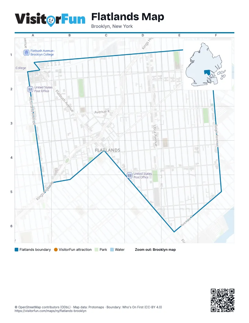
Street index of Flatlands
Each street on the sheet and the grid squares it crosses.
- East 32nd StreetA1, A2, A3, A4, B5
- Flatbush AvenueA1, A2, B3, C3, C4, E6
- New York AvenueA1, A2, B3, B4
- Brooklyn AvenueB1, B2
- East 34th StreetB1, B2, B3, B4
- East 35th StreetB1, B2, B3, B4, B5
- East 37th StreetB1, B2, B3, B4
- East 38th StreetB1, B2, B3, B4, C4
- East 39th StreetB1, B2, B3, C3
- East 40th StreetB1, C1, C2, C3, C4
- Albany AvenueC1, C2, C3
- Avenue HC1, D1, E1
- East 42nd StreetC1, C2, C3
- East 43rd StreetC1, C2, C3, C4
- East 45th StreetC1, C2, C3, D3, D4, D5
- East 46th StreetC1, D1, D2, D3, D4, D5
- Troy AvenueC1, C2, C3, C4
- Avenue ID1, E1, F1, A2, B2, C2, D2
- East 48th StreetD1, D2, D3, D4, D5
- East 49th StreetD1, D2, D3, D4, D5
- East 51st StreetD1, D2, E3, E4, E6
- Kings HighwayD1, C2, D2, C3, B4, C4, A5, B5
- Schenectady AvenueD1, D2, D3, D4, D5
- Utica AvenueD1, D2, D3, D4, D5, E5, E6
- East 52nd StreetE1, E2, E3, E4, E6
- East 53rd StreetE1, E2, E3, E4, E6
- East 54th StreetE1, E2, E3, E4, E6
- East 55th StreetE1, E2, E3, E4, E6
- East 56th StreetE1, E2, E3, E4, E5, E6, F6
- East 57th StreetE1, E2, F3, F4, F5
- Flatlands AvenueE1, F1, D2, E2, C3, D3, B4, C4, B5
- East 58th StreetF1, F2, F3, F4, F5
- East 59th StreetF1, F2, F3, F4, F5
- Ralph AvenueF1, F2, F3, F4, F5
- Aurelia CourtA2
- East 31st StreetA2, A3, A4, A5
- Avenue JB2, C2, D2, F2
- East 36th StreetB2, B3, B4
- Bergen AvenueF2
- East 72nd StreetF2
- East 73rd StreetF2
- Alton PlaceB3, C3
- Avenue KB3, C3, D3, F3
- Avenue LB3, C3, D3, E3, F3, A4
- Hubbard PlaceB3, C3
- East 41st StreetC3
- Harden StreetC3, C4
- Lott PlaceC3, C4
- Overbaugh PlaceC3
- East 66th StreetF3
- Avenue MB4, C4, D4, E4, F4
- Ryder StreetB4, C4
- Avenue NC4, D4, F4, A5, B5
- Avenue PC4
- Baughman PlaceC4
- Coleman StreetC4
- Hendrickson StreetC4
- Kimball StreetC4
- Lotts LaneC4
- Mill LaneE4, F4, E5
- East 64th StreetF4
- East 65th StreetF4
- Mill AvenueF4
- East 33rd StreetB5
- Avenue OD5, F5
- Fillmore AvenueD5, F5
- Avenue TF5, E6, F6
- East 60th StreetF5
- East 61st StreetF5
- Avenue SE6
- Pearson StreetF6
Places on the map
- 5604 Deli Grocery
- Aldi
- Amersfort Park
- Avenue H & Albany Avenue
- Avenue H & East 40th Street
- Avenue H & East 43rd Street
- Avenue H & East 45th Street
- Avenue H & East 48th Street
- Avenue H & East 52nd Street
- Avenue H & East 54th Street
- Avenue H & East 56th Street
- Avenue H & New York Avenue
- Avenue H & Utica Avenue
- Avenue L & East 36th Street
- Avenue L & Flatbush Avenue
- Avenue L & New York Avenue
- Avenue L & Nostrand Avenue
- Avenue N & East 45th Street
- Avenue N & East 46th Street
- Avenue N & East 48th Street
- Avenue N & East 52nd Street
- Avenue N & East 53rd Street
- Avenue N & East 54th Street
- Avenue N & East 55th Street
- Avenue N & East 56th Street
- Avenue N & East 57th Street
- Avenue N & East 58th Street
- Avenue N & Ralph Avenue
- Avenue N & Schenectady Avenue
- Avenue N & Utica Avenue
- Bethel Born Again Church
- BKLN Diner
- Buffet
- Burger King
- Christian Heritage Academy
- Christian Heritage Church
- Church of God
- Church of Lord
- Commander Eugene S Sarsfield Playground
- Congregation Adath Yeshuron
Next to Flatlands
- Paerdegat
© OpenStreetMap contributors (ODbL) · Map data: Protomaps · Boundary: Who's On First (CC-BY 4.0)