

New York map
Highbridge map
A printable two-page map of Highbridge (The Bronx, New York), drawn by VisitorFun from OpenStreetMap. Page two is the street index: every street on the sheet with its grid square, the same list as below.
Open the map (PDF, US Letter)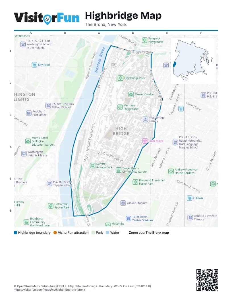
Street index of Highbridge
Each street on the sheet and the grid squares it crosses.
- Exterior StreetC1, C2
- Major Deegan ExpresswayC1, C2, C3, C4, B5, B6, C6
- Boscobel PlaceD1
- Cross Bronx ExpresswayD1
- Edward L. Grant HighwayD1, E1, E2, E3, E4
- Major Deegan Entrance NorthboundD1
- Merriam AvenueD1, D2, D3
- Ogden AvenueD1, D2, D3, C5, C6
- Undercliff AvenueD1, C2, D2
- University AvenueD1, E1, D2, C3, D3, C4, C5
- Washington BridgeD1, E1
- Depot PlaceC2
- Sedgwick AvenueC2, D2, C3, C5, C6
- Plimpton AvenueD2, E2
- West 169th StreetD2, E3
- West 170th StreetD2, E2
- West 171st StreetD2
- Nelson AvenueE2, D3, D4, C5
- Shakespeare AvenueE2, D3, E3, D4
- West 167th StreetC3, D3, D4
- West 168th StreetC3, D3
- Anderson AvenueD3, C5, D5, C6
- Woodycrest AvenueD3, D4, C5, C6
- Summit AvenueC4, C5
- West 165th StreetC4, D4
- West 166th StreetC4, D4
- Jerome AvenueD4, C5, C6
- West 161st StreetC5
- West 162nd StreetC5
- West 163rd StreetC5
- West 164th StreetC5, D5
- East 165th StreetD5
- East 161st StreetC6
Places on the map
- 1434 Undercliff Avenue
- Best Western Plus
- Corporal Irwin Fischer Park
- FDNY EMS Station 17
- FDNY Engine 68/Ladder 49
- Food Universe Marketplace
- High Bridge Library
- Highbridge Houses
- Highbridge Park
- Joker Stairs
- La Isla Community Garden
- Las Casitas Community Garden
- Merriam Playground
- Mosaic Garden
- NYPD SRG 2
- Ogden Plimpton Playground
- P.S. 11X - The Highbridge School
- P.S. 126X - The Dr. Marjorie H. Dunbar Elementary School
- P.S. 73 Bronx
- Roberto Clemente Community Garden
- Sacred Heart Catholic Church
- Summit Avenue Park
- Taqwa Community Farm
- Target Bronx Community Garden
- Woodycrest Community Garden
Next to Highbridge
© OpenStreetMap contributors (ODbL) · Map data: Protomaps · Boundary: Who's On First (CC-BY 4.0)