

New York map
Washington Heights map
A printable two-page map of Washington Heights (Manhattan, New York), drawn by VisitorFun from OpenStreetMap. Page two is the street index: every street on the sheet with its grid square, the same list as below.
Open the map (PDF, US Letter)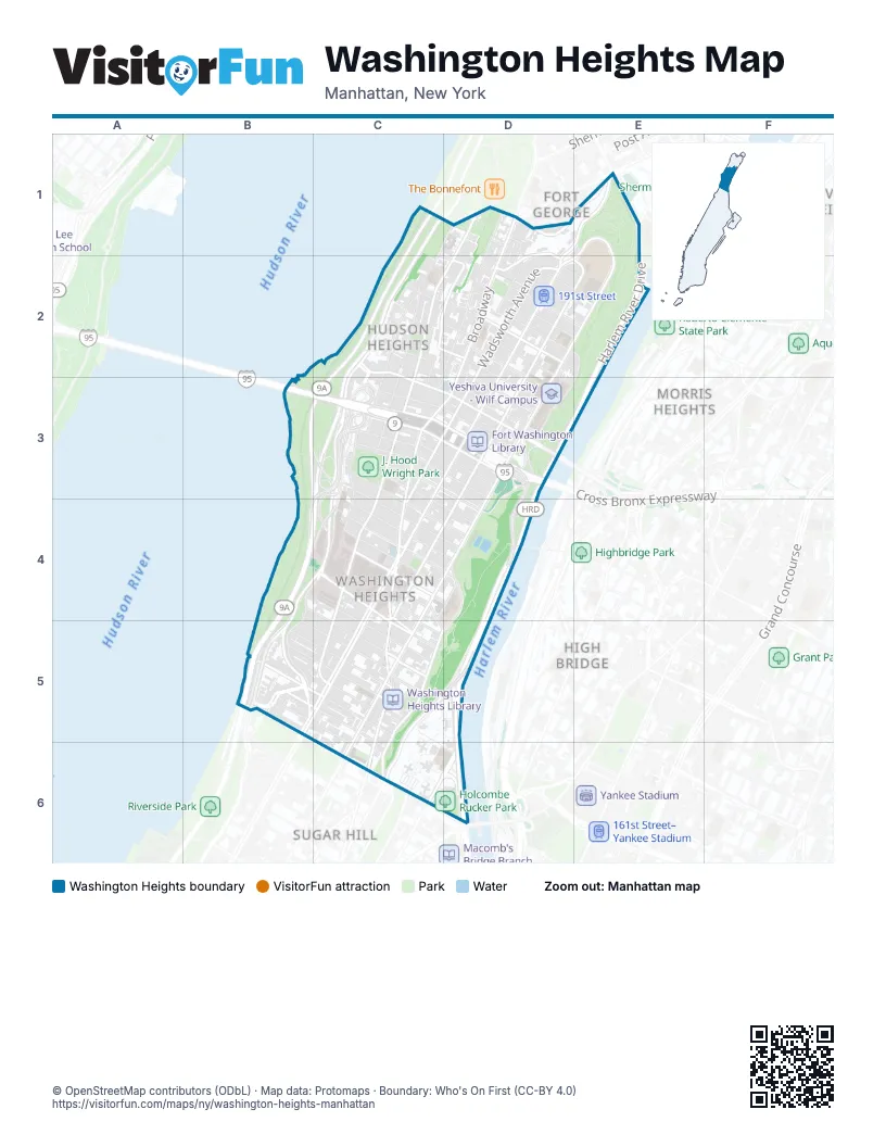
Street index of Washington Heights
Each street on the sheet and the grid squares it crosses.
- Cabrini BoulevardC1, D1, C2, C3
- Henry Hudson ParkwayC1, C2, B3, C3, B4, C4, B5
- West 190th StreetC1, D2, E2
- Bennett AvenueD1, D2, C3
- BroadwayD1, D2, C3, D3, C4, B5, C5
- Broadway TerraceD1, D2
- Ellwood StreetD1
- Fairview AvenueD1, D2
- Fort George HillD1, E1, D2
- Fort Washington AvenueD1, C2, D2, C3, C4, C5
- Hillside AvenueD1, E1
- Margaret Corbin DriveD1
- Margaret Corbin PlazaD1
- Nagle AvenueD1
- Wadsworth TerraceD1, D2
- West 192nd StreetD1, D2, E2
- West 193rd StreetD1, D2, E2
- Dyckman StreetE1
- Fort George AvenueE1, D2, E2
- Harlem River DriveE1, E2, D3, E3, D4, D5, D6
- Sickles StreetE1
- Chittenden AvenueC2
- Colonel Robert Magaw PlaceC2, C3
- Haven AvenueC2, C3, C4
- Lafayette PlazaC2
- Overlook TerraceC2, D2
- Pinehurst AvenueC2, C3
- Riverside DriveC2, C3, B4, C4, B5
- West 181st StreetC2, C3, D3
- West 183rd StreetC2, D2, D3
- West 184th StreetC2, D2, D3
- West 185th StreetC2, D2
- West 186th StreetC2, D2, D3
- West 187th StreetC2, D2, E2
- Amsterdam AvenueD2, E2, D3, C4, D4, C5, C6
- Audubon AvenueD2, E2, D3, C4, D4
- Laurel Hill TerraceD2, E2, D3
- Saint Nicholas AvenueD2, D3, C4, C5, C6
- Wadsworth AvenueD2, C3, C4
- Washington TerraceD2, D3
- West 188th StreetD2
- West 189th StreetD2, E2
- West 191st StreetD2
- George Washington Bridge Lower LevelB3, C3
- George Washington Bridge Upper LevelC3
- South Pinehurst AvenueC3
- Trans-Manhattan Expressway Lower LevelC3, D3
- Trans-Manhattan Expressway Upper LevelC3, D3
- West 172nd StreetC3, C4, D4
- West 173rd StreetC3, C4, D4
- West 174th StreetC3, D4
- West 175th StreetC3, D4
- West 176th StreetC3, D3
- West 177th StreetC3, D3
- West 178th StreetC3, D3
- West 179th StreetC3, D3
- West 180th StreetC3, D3
- Washington BridgeD3
- West 182nd StreetD3
- West 163rd StreetB4, C4, C5
- Jumel PlaceC4, D4
- West 164th StreetC4, C5
- West 165th StreetC4, C5
- West 166th StreetC4, C5
- West 167th StreetC4, C5, D5
- West 168th StreetC4, D4
- West 169th StreetC4
- West 170th StreetC4, D4
- West 171st StreetC4, D4
- Edgecombe AvenueD4, C5, D5, C6
- Edward M. Morgan PlaceB5
- Riverside Drive WestB5
- West 155th StreetB5, C6
- West 156th StreetB5, C6
- West 157th StreetB5, C5, C6
- West 158th StreetB5, C5
- West 160th StreetB5, C5
- West 161st StreetB5, C5
- West 162nd StreetB5, C5
- Harlem River DrivewayC5, C6
- Jackson AvenueC5
- Jumel TerraceC5
- Sylvan TerraceC5
- West 159th StreetC5
- Frederick Douglass BoulevardC6, D6
Places on the map
- (J. Hood Wright Park Playground) Children's Play Area
- 155th Street
- 157th Street
- 157th Street & Broadway at Southeast Corner
- 163rd Street-Amsterdam Av
- 163rd Street–Amsterdam Avenue
- 168th Street
- 168th Street (1)
- 168th Street (A,C)
- 173 Pharmacy
- 174th Street Yard
- 175th Street
- 181 Cabrini
- 181 Gourmet Deli
- 181 Pharmacy
- 181st St (A)
- 181st St (A) upper level
- 181st Street
- 181st Street Urgent Care Center
- 190th St (A)
- 190th St (A) lower level
- 190th Street
- 191st St Station
- 191st Street
- 3000 A.D. Diffusion Piece
- 310 Finest Deli Grocery
- 888 Hudson Thai
- A Feast in the Forest
- ACM Suds 3802
- Addey Ababa
- Advantage Wholesale Supply
- Adventure Playground
- Alexandro Gallery Furniture
- Alianza Dominicana Cultural Center
- Alumni Auditorium
- American Robin, Baltimore Oriole, Blue Jay
- Amsterdam Avenue & West 173rd Street
- Amsterdam Avenue & West 175th Street
- Amsterdam Avenue & West 177th Street
- Amsterdam Avenue & West 178th Street
Next to Washington Heights
- Fort George
- High Bridge
- Morris Heights map
- Sugar Hill
© OpenStreetMap contributors (ODbL) · Map data: Protomaps · Boundary: Who's On First (CC-BY 4.0)