

New York map
Howard Beach map
A printable two-page map of Howard Beach (Queens, New York), drawn by VisitorFun from OpenStreetMap. Page two is the street index: every street on the sheet with its grid square, the same list as below.
Open the map (PDF, US Letter)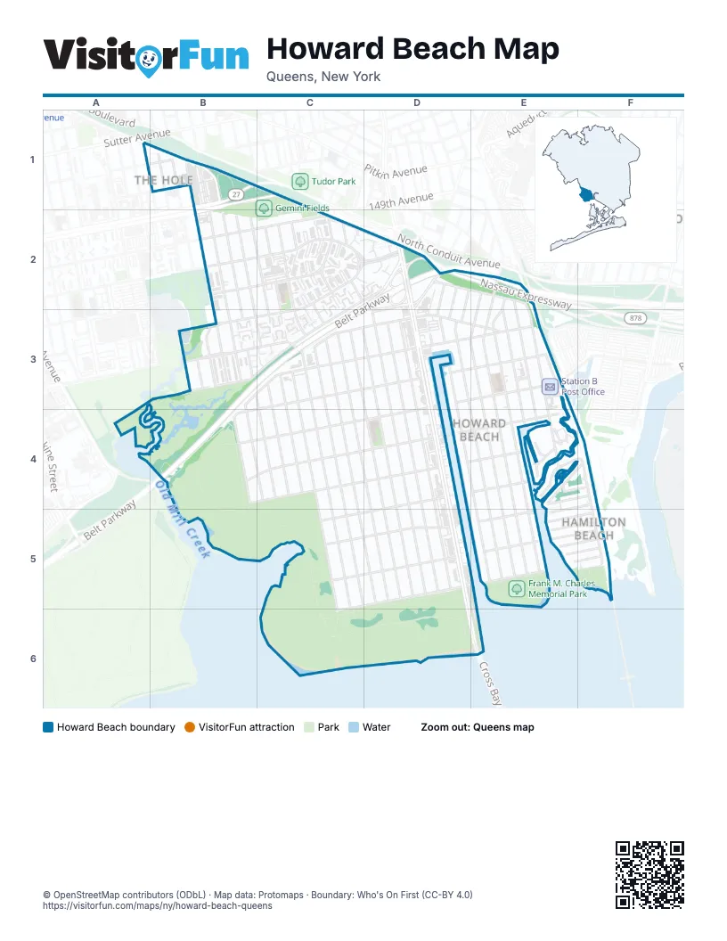
Street index of Howard Beach
Each street on the sheet and the grid squares it crosses.
- 76th StreetB1, B3
- 77th StreetB1, B3
- 78th StreetB1, B3, B4
- 78th Street - Sapphire StreetB1, B2, B3
- 79th StreetB1, B2, B3, B4, C4
- Blake AvenueB1
- Dumont AvenueB1
- Linden BoulevardB1, C1, B2
- South Conduit AvenueB1, C1, C2, D2
- Cedar LaneC1, C2
- 149th AvenueB2, C2
- 151st AvenueB2, C2
- 153rd AvenueB2, C2, D2
- 80th StreetB2, B3, C3, C4
- 81st StreetB2, B3, C3, C4
- 82nd StreetB2, C2, C3, C4
- Loring AvenueB2
- Stanley AvenueB2
- 155th AvenueC2, D2, E2, B3, C3
- 83rd StreetC2, C3, C5, C6
- 84th StreetC2, C3, C5, C6
- 85th StreetC2, C3, C5
- 86th StreetC2, C3, D5
- 88th StreetC2, C3, D5
- 89th StreetC2, C3, D5
- 90th StreetC2, D3, D5
- Nassau ExpresswayC2, D2, E2
- Shore ParkwayC2, D2, C3
- Shore Parkway NorthC2, B3, C3
- Belt ParkwayD2, E2, B3, C3, B4
- Cross Bay BoulevardD2, D3, D4, D5, D6, E6
- Huron StreetD2, D3
- Killarney StreetD2, D3
- Lahn StreetD2, D3
- Shore Parkway SouthD2, D3
- 100th StreetE2, E3, E4
- 101st StreetE2, E3, E4
- 102nd StreetE2, E3, E4
- 99th StreetE2, E3, E4, E5
- Bridgeton StreetE2, E3
- Cohancy StreetE2, E3
- 156th AvenueB3, C3, D3, E3
- 157th AvenueB3, C3, D3, E3
- 75th StreetB3
- Cozine AvenueB3
- Fairfield PlaceB3
- 158th AvenueC3, D3, E3, B4
- 87th StreetC3, D5
- 159th AvenueD3, E3, B4, C4
- 91st StreetD3, D4, D5
- 92nd StreetD3, D5
- 94th StreetD3
- 95th StreetD3, E5
- 96th StreetD3, E5
- 103rd StreetE3
- 159th DriveE3
- 159th RoadE3
- 97th StreetE3, E5
- 98th StreetE3, E5
- Arcade PlaceE3
- Coleman SquareE3
- 160th AvenueB4, C4, D4, E4
- 161st AvenueB4, C4, D4
- 162nd AvenueD4, E4, C5
- 1st StreetE4, F4
- Bridge StreetE4
- BroadwayE4
- Church StreetE4
- Dunton CourtE4, F4
- Rau CourtE4, F4
- Russell StreetE4, F4
- 104th StreetF4, F5
- Davenport CourtF4, E5
- Williams CourtF4
- 163rd AvenueC5, D5, E5
- 164th AvenueC5, D5, E5
- 165th AvenueD5, E5, C6
- 163rd Drive;James CourtE5, F5
- 163rd Road;Burlingame CourtE5, F5
- 164th Avenue;Mckee AvenueE5, F5
- 164th Drive;MonCrief CourtE5, F5
- 164th Road;Calhoun RoadE5, F5
- 165th Avenue;Lockwood CourtE5, F5
Places on the map
- Chase
- Cross Bay Commons
- CVS Pharmacy
- DiVino Pizzeria
- FDNY Engine 331/Ladder 273
- Frank M. Charles Memorial Park
- Gemini Fields
- Hamilton Beach Park
- Howard Beach Branch Queens Borough Public Library
- Howard Beach Station Jamaica Post Office
- Howard Beach–JFK Airport
- Key Food
- Key Food Supermarket
- Launch
- Linden Center
- Linden Star Shopping Center
- McDonald's
- New York Families For Autistic Children
- Our Lady of Grace Church
- P.S. / M.S. - Rockwood Park School
- P.S. / M.S. 146Q - The Howard Beach School
- P.S. / M.S. 232Q - The Lindenwood School
- Petco
- Ragtime
- Ralph’s Creek
- Rockwood Park Jewish Center
- Spring Creek Park
- Starbucks
- Station B Post Office
- Stop & Shop
© OpenStreetMap contributors (ODbL) · Map data: Protomaps · Boundary: Who's On First (CC-BY 4.0)