

New York map
Livingston County map
About 61,561 people live here (Census Bureau, 2024 estimate). The sheet's index lists 300 streets; Main Street, Genesee Expressway and Mill Street cross the most grid squares. Things to do inside the boundary: Letchworth State Park.
Open the map (PDF, US Letter)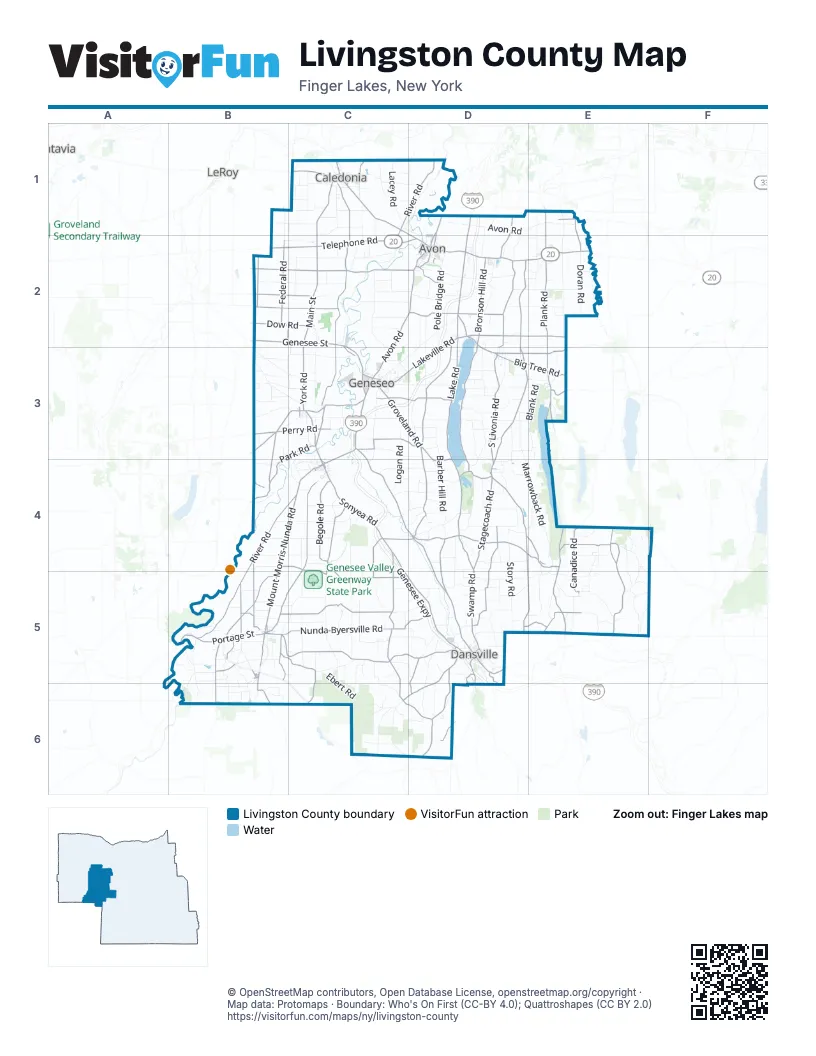
Street index of Livingston County
Each street on the sheet and the grid squares it crosses.
- Genesee ExpresswayD1, D2, C3, D3, C4, C5, D5, D6
- Main StreetC1, C2, C3, D3, C4, D4, B5, C5, D5
- Groveland Station RoadC3, C4, D4, D5
- Nunda-Dansville RoadB5, C5, D5
- Genesee StreetB2, C2, D2, E2, C3, C4
- Telephone RoadB2, C2, D2
- Lakeville RoadD2, C3, D3
- Leicester RoadC1, C2, B3, C3
- Caledonia-Avon RoadC1, D1, D2
- Portage StreetB5
- Perry RoadB3, C3, B5, D6
- Avon RoadC2, D2, C3
- Cuylerville RoadC3
- Geneseo-Mount Morris RoadC3
- Avon-Geneseo RoadD2
- Mill StreetC1, E2, C4, D4, E4, B5, D5
- Mount Morris RoadC3
- East Avon-Lima RoadD2
- East Main RoadE2
- State StreetC1, C4, B5, B6
- Caledonia-Leroy RoadC1
- West Main RoadD2, E2
- Mount Morris-Geneseo RoadC3, C4
- East Main StreetD2, E2
- West Main StreetD2, E2
- Avon-East Avon RoadD2
- Clara Barton StreetD5
- Wadsworth AvenueD2
- South StreetC3
- Ossian StreetD5
- Hornell RoadD5, D6
- Park PlaceC1, D2
- East South StreetC3
- Mary Jemison DriveC3
- State Highway 63B2
- Pine Tavern RoadB3
- Routes 5 and 20E2
- State Highway 36D6
- West Lake RoadD2, D3, D4
- West Swamp RoadD4, D5
- Mount Morris-Nunda RoadB4, C4, B5
- Dansville-Mount Morris RoadC4, C5, D5
- Conesus Springwater RoadD4, E4
- South Livonia RoadD3, D4
- Big Tree RoadD2, D3, E3
- North Main StreetC3, E3, C4, E4
- Plank RoadE2, E3
- Sonyea RoadC4
- Richmond Mills RoadD3, E3
- Rochester StreetD1, E1, D2, E2
- Indian Valley RoadE5
- Flats RoadC2, C3, C4, D4
- North StreetC1, D2, C3, D4, B5
- York RoadB1, B2, C3
- West Henrietta RoadD1, D2
- South Main StreetE3, E4, E5
- Nunda Dalton RoadB5
- Rochester RoadD2
- Dalton Birdsall RoadB6
- Bald Hill RoadE3
- Franklin StreetC3, D5
- Hemlock-Honeoye RoadE3
- Big Tree StreetD3
- Health StreetD5
- Chapel StreetC4
- Foster Wheeler RoadD5
- Commerce DriveD2, D5
- Commercial StreetD3
- South State StreetB5
- North State StreetB5
- Lake AvenueE2
- East State StreetC4
- Ontario StreetE1
- Perine StreetD5
- Leicester StreetC1
- State Highway 15AE3
- Dock StreetD5
- Honeoye RoadE3
- State Highway 15E5
- Rush-Lima RoadE1
- River RoadC1, D1, C2, C3, B4, C4, B5
- Federal RoadB2, D3, D4
- Creek RoadC4, B5, C5
- East Lake RoadD2, D3, E3, D4, F4
- Short Tract RoadB5, B6
- Lakeville Groveland RoadD2, D3
- Nunda-Byersville RoadB5, C5
- Reeds Corners RoadD4, D5
- Tabors Corner RoadE4, E5
- Stone Hill RoadD2, E2
- Park RoadB3, C3, B4
- Carney Hollow RoadD4, E4, D5, E5
- Presbyterian RoadC4, C5
- Stagecoach RoadD4
- Fowlerville RoadC2, D2
- Groveland Hill RoadD3, D4
- Livonia Center RoadD2, D3
- County Line RoadB3, B4, D5, E5
- Begole RoadC4
- Bronson Hill RoadD2
- Poplar Hill RoadD2
- Craig RoadB2, C2
- Kysorville Byersville RoadC4, C5
- Long Point RoadC3, D3
- Rock Spring Hill RoadC5, D5
- East Groveland RoadC3, D3
- Ossian Hill RoadD5, C6, D6
- Picket Line RoadB4, B5
- Groveland RoadC3, D3
- Canadice RoadE4, E5
- West River RoadC1, D1
- Middle RoadC1, C2, D4
- Dow RoadB2, C2
- Dutch Street RoadC4
- Liberty Pole RoadD4, E4
- Linwood RoadB2, C2
- York Road WestB2, C2
- McCurdy RoadD5, D6
- Parker Hill RoadD4, D5
- Wheaton Hill RoadE4
- Oakland RoadB5
- Gibsonville RoadB3, B4
- Triphammer RoadD2
- Scottsburg RoadD4
- Barron RoadB4, C4, C5
- Degroff RoadB5, C5
- Chidsey RoadB5
- South Lima RoadD2
- Stoner Hill RoadC5, D5
- Oak Openings RoadD1, D2
- McNinch RoadC5, C6
- Barkertown RoadB5, C5
- Canaseraga RoadD6
- Redmond RoadC5
- Valley RoadD5, D6
- Sliker Hill RoadD4
- Stewart RoadB2
- Poags Hole RoadD5, D6
- Maple Beach RoadD3, D4
- Wetmore RoadE4
- Sugar Creek RoadC6, D6
- Newville RoadC5, C6
- Kenney RoadC5
- Bragg StreetE1, E2
- Littleville RoadD2
- Becker RoadE5
- Brokaw RoadC5
- Macintyre RoadC2
- Springwater RoadD4
- Pokamoonshine RoadD5, E5
- Walker RoadB2, E5
- River StreetD2, C3
- East River RoadD1
- Martin RoadE1
- Stones Falls RoadD5, D6
- North AvenueD1, D2
- Wheatland Center RoadC1
- Middle River RoadB5
- Linwood Road NorthB2
- Court StreetC3
- North Littleville RoadD2
- County Road 36AF4
- Oakland StreetB5
- North Church StreetB5, C6
- East StreetB5
- Ideson RoadE1
- Perkinsville RoadD5
- Walnut StreetC4, B5
- Works RoadD1
- Marrowback RoadD3, D4, E4
- Jones Bridge RoadB3, C3
- Barber Hill RoadD3, D4
- Story RoadD4, D5
- Logan RoadC3, C4, D4, D5
- Strutt StreetE4, E5
- Clay StreetE2, E3, D5
- Pole Bridge RoadD2, D3
- Lima RoadD2, C3, D3
- Scipio RoadC5
- Dutch Hollow RoadD2, E4, E5
- Cleary RoadD2, D3, E3
- Nations RoadC2, C3
- Ridge Road EastB4, C4
- Frost RoadB4, C4, C5
- Reservoir RoadD2, C3, D3, D5
- North RoadC2, D2, D3
- Sand Hill RoadC1, C4, B5
- Bailey RoadD4, B5, C5
- Old State RoadB3, C3, B6
- Harpers Ferry RoadE4, D5, E5
- Lacey RoadC1
- New RoadB3, C3, B5
- Doran RoadE2
- Hoagland RoadB4, C4
- East Swamp RoadD4
- Jenks RoadD1, D2, E2
- Heath Markham RoadD1, E1, D2
- Covington RoadB3, C3
- Barber RoadD1, B3, D4
- Pennycook RoadB5, B6
- Cowan RoadB2, C2
- White Bridge RoadD5
- Pardee Hollow RoadE5
- Moore RoadC5
- Green RoadC5
- Chandler RoadC3
- Coffee Hill RoadC5, D5
- Ebert RoadC5, C6
- Meyers RoadC5
- Crossett RoadC3
- Batzing RoadC2
- Swartz RoadD4
- North Avon RoadD1
- Retsof RoadC2, C3
- Warner RoadD3, E4, E5, F5
- Shaw RoadC5
- Clark RoadD3, B5
- Woodruff RoadD2, E2, D3
- Spring StreetC1, C2, D2, D3, C4
- Pennemite RoadD3
- Partridge Corners RoadD3, D4
- Dalton RoadE1, E2
- Black Street RoadB1, C1
- York StreetE1, E2
- Adamson RoadC4, D4
- Blank RoadE3
- Pond RoadE2
- Parker RoadC4, B5
- Highbanks RoadB3, C3, B4
- Bath RoadD4
- Marshall RoadD2, D4
- Caledonia RoadC3
- East Park RoadB5
- White RoadE4, C6
- Feely RoadC1
- Shute RoadC5
- Price RoadD3, E4
- McGinty RoadD3, D4, C5
- Dunkley RoadB3, C3
- Black Run RoadC6, D6
- Anderson RoadB2, C2, D4
- Peoria RoadB3, C3
- Pioneer RoadC1, C4
- Bonner RoadC6
- Conesus Sparta Townline RoadD4
- Cameron RoadC1, D1
- Mount Pleasant RoadC2, D5
- Blank Hill RoadC6, D6
- Shay RoadC5, D5, C6
- McIntyre RoadC1
- Lake RoadD2, E4
- Vista HillD5
- Turkey Hill RoadD3
- Iroquois RoadC1
- Scott Hill RoadC6
- Swanson RoadC4
- Limerick RoadC2
- South River RoadB5, B6
- Peglow RoadE4, E5
- Quarry RoadC1, C2
- Hogmire RoadC2, D2
- Miller RoadC5, D5, E5
- Brian RoadB3
- Jay Knapp RoadD5, D6
- Schwab Hollow RoadE5
- Wagner RoadD6
- Decker RoadD3
- South Avon RoadC2, D2
- Chase RoadE2
- Garden StreetD2
- Marvin Hill RoadE5
- Carney RoadC5, D5
- McCorkindale RoadC1
- Niver RoadD3, E3
- Bennett Hill RoadC4, D4
- Houston RoadC2
- Union Corners RoadC4, C5
- Dannack Hill RoadC6
- Wallace RoadB3
- Ellicott RoadB2, C2
- Christian RoadC5, D5
- Morris RoadD4
- Coe RoadD3
- East AvenueC1, D3, E3, E4
- Mission RoadD3, E3
- Visitor Center RoadC3, C4
- Casey RoadC2
- Valleyview RoadB6
- Pucker StreetD4
- Kelleman RoadD4
- Alvord RoadC4
- McKay RoadC5, D5
- Elm RoadD2
- McEwen RoadB1, B2
- Reed RoadC5
- Hoataling RoadD6
- Mead Hill RoadD5, E5
- Upper Mount Morris RoadC3
- Robinson RoadE4, B5
- Moyer RoadC4
Things to do on the Livingston County map
Places on the map
- Byersville
- Caledonia Country Club
- Caledonia Fish Hatchery
- Canaseraga State Forest
- Conesus CDP
- Conesus Golf Club
- Conesus Lake
- Cumminsville
- Cuylerville
- Dalton
- Dansville Municipal Airport
- East Avon
- Empire Dragway
- Farview Golf Course
- Fowlerville
- Genesee Valley Greenway State Park
- Greigsville
- Groveland Station
- Hemlock
- Hemlock Lake
- Hemlock-Canadice State Forest
- Highbanks Campgrounds
- Highbanks Recreation Area
- Horseshoe Pond
- Hunt
- Kysorville
- Lakeville
- Letchworth State Park
- Linwood
- Livonia Center
- Log Pond
- Mount Morris Lake
- Ossian State Forest
- Piffard
- Rattlesnake Hill Wildlife Management Area
- Retsof
- Scottsburg
- Sonyea State Forest
- South Lima
- Springwater
Next to Livingston County
- Batavia
- LeRoy
© OpenStreetMap contributors, Open Database License, openstreetmap.org/copyright · Map data: Protomaps · Boundary: Who's On First (CC-BY 4.0); Quattroshapes (CC BY 2.0)