

New York map
Finger Lakes map
The sheet's index lists 36 highways; I-90, I-86 and I-390 cross the most grid squares. Things to do inside the boundary: Allan H. Treman State Marine Park, Beechwood State Park and Buttermilk Falls State Park. Also on it: Auburn, Avon and Batavia.
Open the map (PDF, US Letter)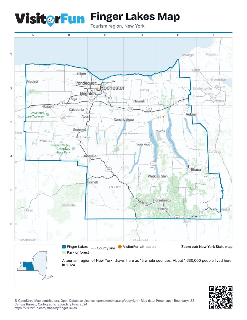
Highway index of Finger Lakes
Each highway on the sheet and the grid squares it crosses.
- I-86B5, C5, D5, E5, E6, F6
- I-90A2, A3, B2, C2, C3, D3, E2, E3
- I-99D5, D6
- I-390B3, B4, C2, C3, C4, C5
- I-490B2, C2, C3
- I-590C2
- US 15D5, D6
- US 20A3, B3, C3, D3, E3
- US 20AB3
- NY 5A3, B3, C3, D3, E2, E3
- NY 13E4, E5, F4
- NY 14D2, D3, D4, D5, E5
- NY 17B5, C5, D5, E5, E6
- NY 19B2
- NY 21C3, D2, D3
- NY 31A2, B2, C2, D2
- NY 33A3
- NY 34E4, E5
- NY 38E3, F4
- NY 39B3
- NY 63A2, A3, B3
- NY 64C3
- NY 77A3
- NY 79E4, E5, F5
- NY 96E4, E5
- NY 98A2, A3
- NY 104C2, D2, E2
- NY 204C2
- NY 332C3, D3
- NY 366F4
- NY 370E2
- NY 390C2
- NY 408B3
- NY 414D5, E3
- NY 531B2
- NY 590C2
Things to do on the Finger Lakes map
- Allan H. Treman State Marine Park
- Beechwood State Park
- Buttermilk Falls State Park
- Cayuga Lake State Park
- Center City Visitor Information Center
- Chemung County Historical Society
- Corning Museum of Glass
- Durand Eastman Park
- Ellison Park
- Fair Haven Beach State Park
- Fillmore Glen State Park
- Fingerlakes Mall
- Ganondagan State Historic Site
- Genesee Country Village & Museum
- Genesee Valley Park
- George Eastman Museum
- Herbert F. Johnson Museum of Art
- Irondequoit Bay Park West
- Keuka Lake State Park
- Letchworth State Park
- Medina Railroad Museum
- Memorial Art Gallery
- Mendon Ponds Park
- Museum of the Earth
- Ontario Beach Park
- Robert H. Treman State Park
- Rochester Museum and Science Center
- Rockwell Museum
- Sampson State Park
- Seneca Lake State Park
- Seneca Park Zoo
- Six Flags Darien Lake
- Sonnenberg Gardens and Mansion State Historic Park
- Stewart Park
- Stony Brook State Park
- Taughannock Falls State Park
- The History Center in Tompkins County
- The Shops at Ithaca Mall
- The Strong National Museum of Play
- Washington Grove
- Watkins Glen State Park
- Women's Rights National Historical Park
- Woodlawn National Cemetery
Places on the map
- Auburn
- Avon
- Batavia
- Brighton
- Caledonia
- Canandaigua
- Corning
- Dansville
- Elmira
- Geneseo
- Hilton
- Hornell
- Horseheads
- Irondequoit
- Ithaca
- Medina
- Newark
- Penn Yan
- Riga
- Rochester
- Watkins Glen
Next to Finger Lakes
- Central New York map
- Chautauqua-Allegheny map
- Greater Niagara
- Thousand Islands-Seaway map
- Pennsylvania Wilds
- Upstate PA
© OpenStreetMap contributors, Open Database License, openstreetmap.org/copyright · Map data: Protomaps · Boundary: U.S. Census Bureau, Cartographic Boundary Files 2024