

New York map
Longwood map
A printable two-page map of Longwood (The Bronx, New York), drawn by VisitorFun from OpenStreetMap. Page two is the street index: every street on the sheet with its grid square, the same list as below.
Open the map (PDF, US Letter)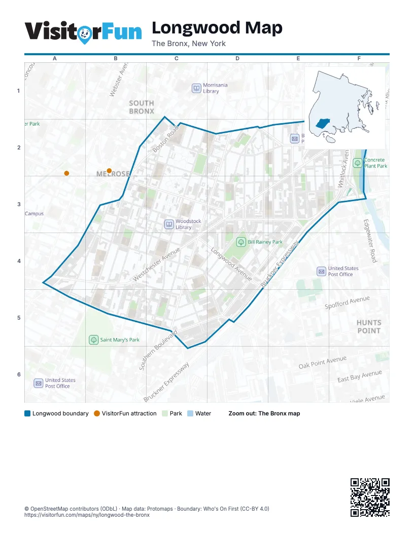
Street index of Longwood
Each street on the sheet and the grid squares it crosses.
- East 167th StreetC1, D2, E2, F2
- Franklin AvenueC1, B2, C2
- Home StreetE1, C2, D2, E2, F2
- West Farms RoadE1, E2
- Boston RoadB2, C2
- East 164th StreetB2, C2, D3
- East 165th StreetB2, C2, E2, F2, D3, E3
- Third AvenueB2, B3, A4
- Weiher CourtB2
- Cauldwell AvenueC2, B3, B4, B5
- East 166th StreetC2, D2
- Forest AvenueC2, C3, C4
- Jackson AvenueC2, C3, B4, B5
- Tinton AvenueC2, C3, C4, C5
- Trinity AvenueC2, C3, B4, B5
- Union AvenueC2, D2, C3, C4, C5
- Hall PlaceD2, D3
- Intervale AvenueD2, D3, D4
- Kelly StreetD2, D3, D4, C5
- Prospect AvenueD2, C3, D3, C4, C5
- Reverend James A. Polite AvenueD2, D3, D4
- Tiffany StreetD2, D3, D4, E4
- Bryant AvenueE2, E3
- East 169th StreetE2
- Faile StreetE2, E3
- Fox StreetE2, E3, E4, C5, D5
- Hoe AvenueE2, E3
- Simpson StreetE2, E3, E4
- Southern BoulevardE2, E3, D4, E4, C5, D5
- Vyse AvenueE2
- Westchester AvenueE2, F2, C3, D3, E3, A4, B4, C4
- Edgewater RoadF2
- Longfellow AvenueF2, F3
- Lowell StreetF2
- Sheridan BoulevardF2
- Whitlock AvenueF2, F3
- Brook AvenueB3, A4, A5
- Eagle AvenueB3, B4, B5
- East 156th StreetB3, B4, C4, D4, D5
- East 157th StreetB3, B4
- East 158th StreetB3, C4
- East 159th StreetB3
- East 160th StreetB3, C3, C4
- East 161st StreetB3, C3, D4
- East 162nd StreetB3, C3, D3
- East 163rd StreetB3, C3, D3, E3
- Saint Ann's AvenueB3, B4
- Washington AvenueB3
- Beck StreetD3, D4, C5, D5
- Dawson StreetD3, C4, D4
- Hewitt PlaceD3, C4, D4
- Rogers PlaceD3, D4
- Aldus StreetE3, F3
- Bruckner BoulevardE3, F3, D4, E4, D5
- Bruckner ExpresswayE3, F3, D4, E4, D5
- Hunts Point AvenueE3
- Bergen AvenueA4, B4
- East 149th StreetA4, A5, B5, C5
- East 151st StreetA4, B5, C5
- East 152nd StreetA4, B4, C5
- East 153rd StreetA4, B4
- East 154th StreetA4
- East 155th StreetA4, C4
- Elton AvenueA4
- Concord AvenueB4, B5
- Rae StreetB4
- Avenue Saint JohnC4, C5
- Leggett AvenueC4, D4, D5
- Longwood AvenueC4, D4
- Macy PlaceC4
- Wales AvenueC4, B5, C5
- Lafayette AvenueD4
- Barretto StreetE4
- East 150th StreetB5, C5
- Pontiac PlaceB5
- Austin PlaceC5, C6
- Timpson PlaceC5, D5
Places on the map
- 20/20 Wireless
- 24hr Pawn Shop & repairs
- 3rd Avenue & Boston Road
- 3rd Avenue & East 150th Street
- 3rd Avenue & East 153rd Street
- 3rd Avenue & East 158th Street
- 3rd Avenue & St Ann’s Avenue
- 3rd Avenue-149th Street
- 3rd Avenue–149th Street
- Abigail Playground
- Accion Academy
- AECI 1 Charter School
- African Methodist Episcopal Zion Church
- Al Quiñones Playground
- Aldi
- Aldus 111 Tenants Association Community Garden
- ArchCare
- Arturo A. Schomburg Satellite Academy Bronx
- Assembly Christian Church
- At&t
- AutoZone
- Banco Popular
- Basil Behagen Playground
- Benjamin Gladstone Square
- Bergen Avenue & East 149th Street
- Bethany Lutheran Church
- Big Pun mural
- Bill Rainey Park
- BLK Projek Libertad Urban Farm
- Boca Pharmacy
- Boston Market
- Boston Road & East 165th Street
- Boston Road & East 166th Street
- Boulevard Post Office
- Bronx Career and College Preparatory High School
- Bronx Charter School for Excellence 6
- Bronx International High School
- Bronx Regional High School
- Bronx Spanish Evangelical Church
- Bronx Studio School for Writers and Artists
Next to Longwood
- Hunts Point
- Melrose
- Morrisania map
- South Bronx
© OpenStreetMap contributors (ODbL) · Map data: Protomaps · Boundary: Who's On First (CC-BY 4.0)