

New York map
Middle Village map
A printable two-page map of Middle Village (Queens, New York), drawn by VisitorFun from OpenStreetMap. Page two is the street index: every street on the sheet with its grid square, the same list as below.
Open the map (PDF, US Letter)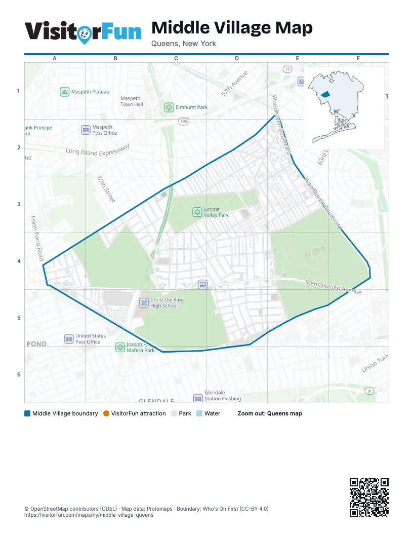
Street index of Middle Village
Each street on the sheet and the grid squares it crosses.
- 86th StreetE1
- Eliot AvenueE1, A4
- Woodhaven BoulevardE1, E2, E3, F3, F4
- 61st DriveD2, B3, B4
- 61st RoadD2, E2, B3, B4
- 62nd AvenueD2, E2, C3, A4, B4
- 82nd PlaceD2, D3, E3
- 83rd PlaceD2, E2, E3
- 83rd StreetD2, E3, E5
- 84th PlaceD2, E2, E3
- 84th StreetD2, E2, E3, E5
- Caldwell AvenueD2
- Dry Harbor RoadD2, E2, D3, E3
- 62nd DriveE2, C3, B4, C4
- 62nd RoadE2, A4, B4, C4
- 63rd AvenueE2, D3, E3
- 63rd RoadE2
- 85th StreetE2
- Alderton StreetE2
- Dana CourtE2, E3
- 67th StreetB3, B4
- 69th StreetB3, C4, C5
- 69th LaneC3, C4
- 70th StreetC3, C4, C5
- 71st StreetC3, C4, C5
- 72nd StreetC3, C4
- 74th StreetC3, D4, D5, D6
- 75th PlaceC3, D4
- 75th StreetC3, D4, D5
- 76th StreetC3, D3, D4, D5
- 77th StreetC3, D3, D4
- Juniper Boulevard NorthC3, D3
- Juniper Boulevard SouthC3, D3, C4
- Lutheran AvenueC3
- Pleasantview StreetC3, C4
- 64th RoadD3, E3
- 77th PlaceD3, D4
- 78th StreetD3, D4, D5
- 79th StreetD3, D4, D5
- 80th StreetD3, E3, E4, E5
- 81st StreetD3, E5
- 82nd StreetD3, E3
- Cowles CourtD3, E3
- Furmanville AvenueD3, E3, D4
- Penelope AvenueD3, E3, C4
- Fleet CourtE3
- Goldington CourtE3
- 66th AvenueF3
- 62nd StreetA4
- 63rd StreetA4
- 64th StreetA4
- 65th StreetA4, A5
- Admiral AvenueA4, A5, B5
- Fresh Pond RoadA4
- Metropolitan AvenueA4, B4, C4, D4, E4, B5, C5
- Mount Olivet CrescentA4, B4
- 65th LaneB4, B5
- 65th PlaceB4, B5
- 68th StreetB4
- Rentar PlazaB4, B5
- 65th DriveC4, D4
- 66th DriveC4, D4
- 66th RoadC4, D4
- 69th PlaceC4
- 73rd PlaceC4, D4, D5, D6
- Juniper Valley RoadC4, D4, E4
- 67th RoadD4, E4, F4, D5
- 79th PlaceD4
- Gray StreetD4
- Cooper AvenueF4, D5, E5, F5
- Yellowstone BoulevardF4
- Terrace CourtB5
- Prospect AvenueC5
- 67th DriveD5, E5
- 68th AvenueD5, E5
- 68th RoadD5, E5
- 69th AvenueD5, E5
- 69th DriveD5, E5
- 69th RoadD5, E5
- 70th AvenueD5
- Cook AvenueD5
- Valentine PlaceE5
- 88th StreetF5
- 71st AvenueD6
Places on the map
- All Faiths Cemetery
- Brennan Field
- C-Town
- Christ the King High School
- Community United Methodist Church
- CVS Pharmacy
- Jewish Center of Forest Hills West
- Juniper Valley Park
- Middle Village-Metropolitan Avenue
- Our Lady of Hope
- P.S. / I.S. 128Q - The Lorraine Tuzzo, Juniper Valley Elementary School
- P.S. / I.S. 49 - The Dorothy Bonawit Kole School
- P.S. / I.S. 87Q - The Middle Village School
- Rego Marketplace
- Saint John Cemetery
- Saints Michael and Gabriel Orthodox Church
- The Shops at Rentar Plaza
- Union Hill
- United States Post Office Middle Village Station
- Wendy's
Next to Middle Village
- Fresh Pond Junction
- Glendale
- Walden Terrace
© OpenStreetMap contributors (ODbL) · Map data: Protomaps · Boundary: Who's On First (CC-BY 4.0)