

New York map
Midwood map
A printable two-page map of Midwood (Brooklyn, New York), drawn by VisitorFun from OpenStreetMap. Page two is the street index: every street on the sheet with its grid square, the same list as below.
Open the map (PDF, US Letter)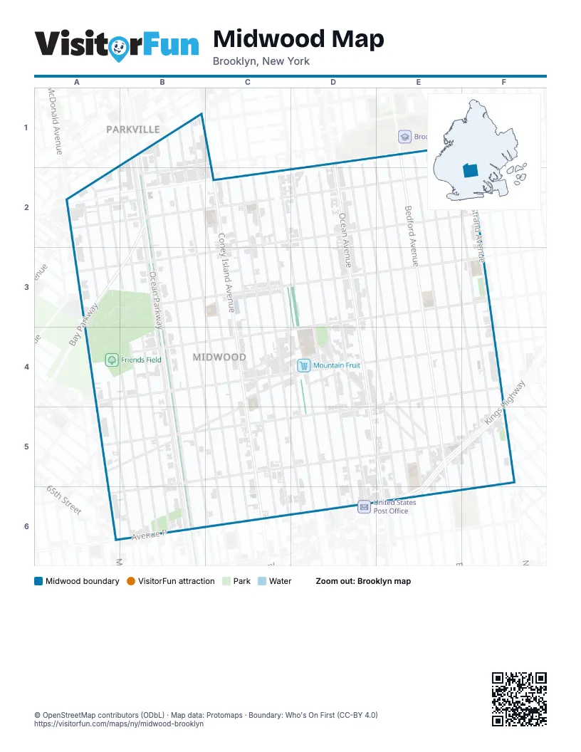
Street index of Midwood
Each street on the sheet and the grid squares it crosses.
- East 10th StreetB1, B2, C5
- East 7th StreetB1, B2, B5
- East 8th StreetB1, B2, C5
- East 9th StreetB1, B2, C5
- East 21st StreetD1, D2, E5
- East 22nd StreetD1, D2, E4, E5
- East 23rd StreetD1, E2, E5
- Ocean AvenueD1, D2, D3, D5, E5
- Bedford AvenueE1, E2, E5
- East 24th StreetE1, E2, E5
- East 26th StreetE1, E2, E5, F6
- East 27th StreetE1, E2, F5
- East 28th StreetE1, E2, E3, F4, F5
- East 29th StreetE1, E2, F5
- Nostrand AvenueF1, F2, F4, F5
- 20th AvenueA2
- 47th StreetA2
- Avenue IA2, B2, C2, D2
- East 2nd StreetA2, A3, A4, A5
- East 3rd StreetA2, A3, B4, B5
- East 4th StreetA2, A3, B3, B4, B5
- Elmwood AvenueA2, B2
- Foster AvenueA2
- McDonald AvenueA2, A3, A6
- Walsh CourtA2, B2
- Avenue HB2
- Bay ParkwayB2, A3, B3
- East 5th StreetB2, B3, B4, B5
- Ocean ParkwayB2, B3, B5, B6
- Coney Island AvenueC2, C5
- East 12th StreetC2, C5
- East 13th StreetC2, C5
- East 14th StreetC2, C4, D5, D6
- East 15th StreetC2, D4, D5
- East 16th StreetC2, D3, D4, D5
- Avenue JD2, B3
- East 17th StreetD2, D5
- East 18th StreetD2, D5
- East 19th StreetD2, D5
- Avenue KB3, D3
- Cary CourtC3
- Avenue LF3, B4, C4, D4
- Avenue MB4, C4, D4, E4
- Chestnut AvenueC4, D4
- Elm AvenueC4, D4
- Locust AvenueC4, D4
- Roder AvenueC4, B5
- Bay AvenueD4, E5
- Cedar StreetD4
- Avenue NE4, B5, D5
- Olean StreetE4, E5
- Kings HighwayF4, E5, F5, E6
- Ryder AvenueB5
- Avenue OC5, D5, E5, F5
- 65th StreetA6
- Avenue PC6, D6, E6
Places on the map
- Advent Gravesend Church
- Amazing Savings
- Apple Bank
- Atlantis Super Wash Laundromat
- AutoZone
- Avenue J
- Avenue M
- Avenue N
- Avenue P
- Bay Parkway
- Berry Goods Supermarket
- Beth Torah
- Brooklyn Public Library
- Chase
- Colonel David Marcus Playground
- Colonel David Marcus Playground Handball Courts
- Congregation Kol Israel
- East Midwood Jewish Center
- Eastern Fruits and Vegetables
- Edward R. Murrow High School
- Enterprise
- Extra Space Storage
- Freddy's Market
- Friends Field
- Glatt Mart
- I.S. 240 - Andries Hudde Junior High School
- Investors Bank
- Kent Theater
- Key Food
- Lisovetsky Memorial Home Inc
- Maimonides Midwood Community Hospital
- Merkaz Hasimcha
- Midwood High School Field
- Mobil
- Moishe's Discount Supermarket
- Mountain Fruit
- New York Engine Company 250
- Ocean Fruit
- P.S. / I.S. 99 - Isaac Asimov School of Science & Literature
- P.S. 193 - The Gil Hodges School
Next to Midwood
- Parkville
© OpenStreetMap contributors (ODbL) · Map data: Protomaps · Boundary: Who's On First (CC-BY 4.0)