

New York map
Mill Basin map
A printable two-page map of Mill Basin (Brooklyn, New York), drawn by VisitorFun from OpenStreetMap. Page two is the street index: every street on the sheet with its grid square, the same list as below.
Open the map (PDF, US Letter)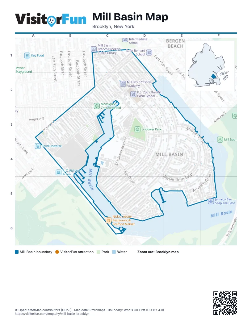
Street index of Mill Basin
Each street on the sheet and the grid squares it crosses.
- East 63rd StreetC1, C2, D2, D3, D4, C5, D5
- East 64th StreetC1, D2, D3, D4, C5, D5
- East 65th StreetC1, D2, D3, E3, D4, E4, C5, D5
- Mill AvenueC1, C2, D3, C4, D4, C5
- Mill LaneC1
- Avenue TD1, C2, A3, B3
- Avenue UD1, D2, B3, C3, A4, B4
- East 66th StreetD1, D2, E2, E3, D4, E4, D5, C6
- East 67th StreetD1
- East 58th StreetB2, C3
- East 59th StreetB2, C2, C3
- East 60th StreetC2
- East 61st StreetC2
- Strickland AvenueD2, D3, C4, C5
- East 52nd StreetA3, B4
- East 53rd PlaceA3, B4
- East 53rd StreetA3, A4
- East 54th StreetB3
- East 55th StreetB3
- East 56th StreetB3
- East 57th StreetB3, C3
- Pearson StreetB3
- East 60th PlaceD3, D4
- Mayfair Drive NorthD3, E3, E4
- Barlow Drive NorthE3, E4
- Whitman DriveE3, F3, F4, D5, E5, D6
- Avenue VB4
- Flatbush AvenueB4, B5
- 56th DriveC4, D5, D6
- East 57th PlaceC4, D4
- East 59th PlaceC4, D4
- Mayfair Drive SouthC4, D4, E4, E5
- Barlow Drive SouthE4
- Bassett AvenueE4, F4
- Gaylord Drive NorthE4
- Gaylord Drive SouthE4
- Arkansas DriveF4, D5, E5, F5, D6
- National DriveF4, C5, E5, F5, C6, D6
- Dakota PlaceD5, E5
- Indiana PlaceE5
- Kansas PlaceE5
- Montana PlaceF5
Places on the map
- Chase Bank
- Exxon
- Kings Plaza Car Lot
- Kings Plaza Shopping Center
- Lindower Park
- Lowe's
- Mill Basin Yeshiva Academy
- Monsignor Crawford Field
- Nick's Lobster Restaurant & Seafood Market
- P.S. 236 - The Mill Basin School
- The Home Depot
Next to Mill Basin
© OpenStreetMap contributors (ODbL) · Map data: Protomaps · Boundary: Who's On First (CC-BY 4.0)