

New York map
New Dorp map
A printable two-page map of New Dorp (Staten Island, New York), drawn by VisitorFun from OpenStreetMap. Page two is the street index: every street on the sheet with its grid square, the same list as below.
Open the map (PDF, US Letter)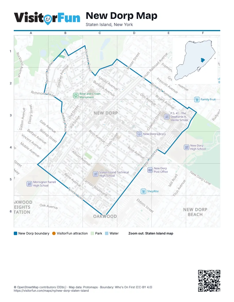
Street index of New Dorp
Each street on the sheet and the grid squares it crosses.
- Beacon AvenueB1, B2
- Geldner AvenueB1, B2
- Walden AvenueB1, B2
- Bancroft AvenueC1, D1, E2
- Bryant AvenueC1, D2, E3
- Richmond RoadC1, B2, C2, B3
- Kayla CourtA2
- Summit AvenueA2
- 1st StreetB2, B3
- Foxholm StreetB2, C2
- Luigi PlaceB2
- New Dorp LaneB2, C3, D3, E4
- Nightingale StreetB2
- Odin StreetB2
- Rose AvenueB2, B3, C3, C4, D4
- Saint Stephens PlaceB2, C2
- Sydney PlaceB2
- Walnut PlaceB2
- 2nd StreetC2, B3
- 3rd StreetC2, B3, C3, B4
- Allison PlaceC2, D2
- Altamont StreetC2
- Burbank AvenueC2, D2, D3, E4
- Cloister PlaceC2, C3
- Kruser StreetC2, D2
- Steele AvenueC2, C3
- Edison StreetD2, D3
- Locust AvenueD2, E3, E4
- North Railroad AvenueD2, C3
- Otis AvenueD2, E3
- South Railroad AvenueD2, C3, B4, B5
- 4th StreetB3, C3
- Amboy RoadB3, A4, B4, A5
- New Dorp PlazaB3, C3, B4
- Oakley PlaceB3
- Prospect PlaceB3
- Ross AvenueB3, C3, C4, D4, D5
- 8th StreetC3, B5
- Bache AvenueC3, D3, E4
- Jacques AvenueC3, D3, E4
- 10th StreetD3, C4, B5, C5
- 9th StreetD3, C4
- Clawson StreetE3, D4, C6
- Hylan BoulevardE3, D4, E4, D5, C6, D6
- Arc PlaceA4, B4, A5
- Mobile AvenueA4
- 7th StreetB4, C4
- Allison AvenueB4, C5, D5
- Beach AvenueB4, C4, D5
- Behan CourtB4
- Belfast AvenueB4
- Bishop StreetB4
- Cannon BoulevardB4, B5, C5, C6
- Dale AvenueB4
- Francine CourtB4
- Princeton AvenueB4, B5, C5, D6
- Vincent AvenueB4
- Lindbergh AvenueC4, D5
- Sterling AvenueC4, D4, D5
- Coddington AvenueD4, E4
- Reno AvenueB5, C6
- Tysens LaneB5, C6
- Colgate PlaceC5
- Ella PlaceC5, B6
- Isora PlaceC5, C6
- Thomas PlaceC6
Places on the map
- HL Supermarket
- New Dorp
- New Dorp Library
- Our Lady Queen of Peace Catholic Church
- Our Lady Queen of Peace School
- P.S. 41 - The Stephanie A. Vierno School
- Postal Connections
- Rose and Crown Monument
- Staten Island Technical High School
- Walter Edwards Grady United States Post Office Building
Next to New Dorp
- New Dorp Beach map
- Oakwood map
- Oakwood Heights Station
© OpenStreetMap contributors (ODbL) · Map data: Protomaps · Boundary: Who's On First (CC-BY 4.0)