

New York map
North Bayside map
A printable two-page map of North Bayside (Queens, New York), drawn by VisitorFun from OpenStreetMap. Page two is the street index: every street on the sheet with its grid square, the same list as below.
Open the map (PDF, US Letter)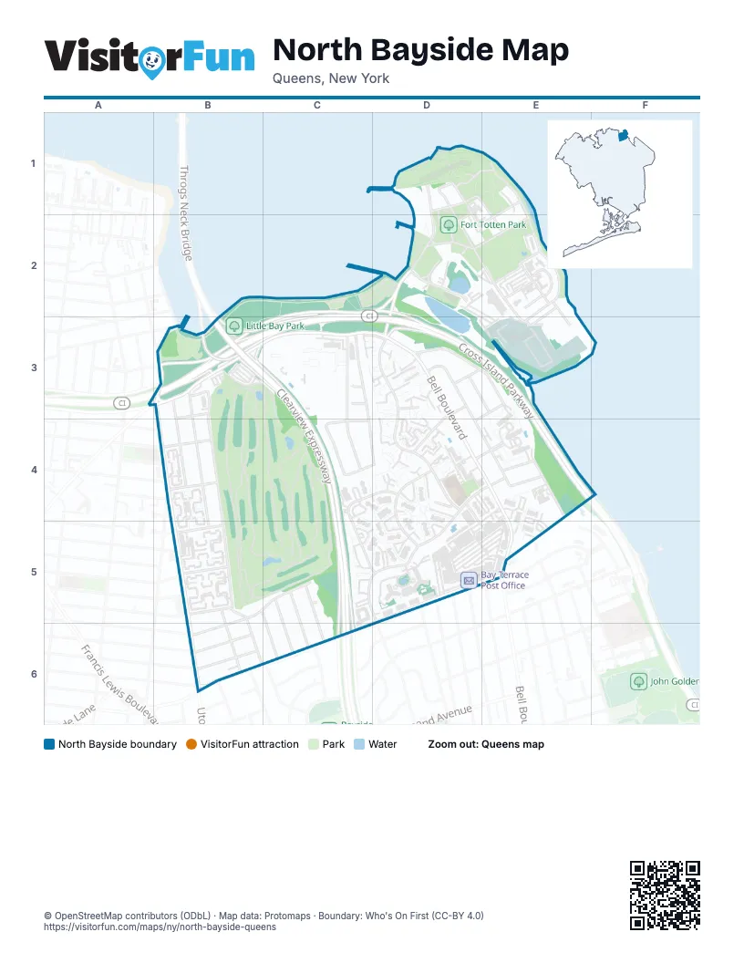
Street index of North Bayside
Each street on the sheet and the grid squares it crosses.
- Abbot RoadD1
- Bayside StreetD1, D2
- Chapel RoadD1, D2
- Jarman RoadD1, D2
- Murray AvenueD1, D2, E2, E3
- North LoopD1
- Ordnance RoadD1, E1
- Sylvester LaneD1, D2
- Whistler AvenueD1, E1, E2
- Shore RoadE1, E2
- Walter Reed RoadE1, D2
- Cross Island ParkwayC2, D2, B3, C3, D3, E3, E4
- Cross Island Parkway Service RoadC2, D2, B3, C3, D3
- Duane RoadD2
- Officers DriveD2
- Totten RoadD2, D3
- Underhill RoadD2
- Weaver RoadD2, E2
- Willets StreetD2
- East LoopE2
- General R. W. Berry DriveE2, E3
- Pratt AvenueE2
- Red Cross LaneE2
- Sargeant Beers AvenueE2, E3
- Sergeant Beers LaneE2, E3
- Story AvenueE2
- Theatre RoadE2
- Westaway RoadE2
- 14th RoadB3
- 15th AvenueB3, C3, D3
- 15th RoadB3, D3, C4
- 200th StreetB3, B4, B6
- 201st StreetB3, B4, B5
- 202nd StreetB3, B4, B5
- Clearview ExpresswayB3, C3, C4, C5, C6
- Cryders LaneB3
- Throgs Neck BridgeB3
- Utopia ParkwayB3, B4, B5, B6
- 14th AvenueC3, D3
- 208th PlaceC3, C4
- 209th StreetC3, C4, D4
- 16th AvenueD3, B4, D4
- 212th StreetD3, D4, D5
- 215th StreetD3, D4, E4
- 216th StreetD3, E3
- Bell BoulevardD3, D4, E4, E5
- Water's Edge DriveD3, E3
- 17th AvenueE3, B4, D4
- 16th RoadB4
- 17th RoadB4
- 18th AvenueB4, C4, D4, E4
- 15th DriveC4, D4
- 208th StreetC4
- Corporal Kennedy StreetC4, C5, D5
- 211th StreetD4, D5
- 213th PlaceD4, D5
- 23rd AvenueD4, E4, B5, C5, D5, B6
- Bay LaneD4
- 217th StreetE4
- 23rd RoadE4, C5
- 19th AvenueB5
- 204th StreetB5
- 20th AvenueB5
- 21st AvenueB5
- 21st RoadB5
- 22nd AvenueB5
- 205th StreetC5
- 206th StreetC5
- 207th StreetC5
- 210th PlaceD5
- 210th StreetD5
- 26th AvenueD5, E5, B6, C6
- 213th StreetE5
- 24th AvenueE5, B6
- 24th RoadB6
Places on the map
- 638
- Bay Terrace Post Office
- Baybridge Townhouse Codominiums
- Clearview Park
- Fort Totten Army Reserve
- Fort Totten Lake
- Fort Totten Park
- Fort Totten Pool
- Little Bay Park
- Michael Court
- P.S. 169Q - The Bay Terrace School
- Queens Public Library at Bay Terrace
- Stop & Shop
- Vivo Mediterranean grill
© OpenStreetMap contributors (ODbL) · Map data: Protomaps · Boundary: Who's On First (CC-BY 4.0)