

New York map
Ozone Park map
A printable two-page map of Ozone Park (Queens, New York), drawn by VisitorFun from OpenStreetMap. Page two is the street index: every street on the sheet with its grid square, the same list as below.
Open the map (PDF, US Letter)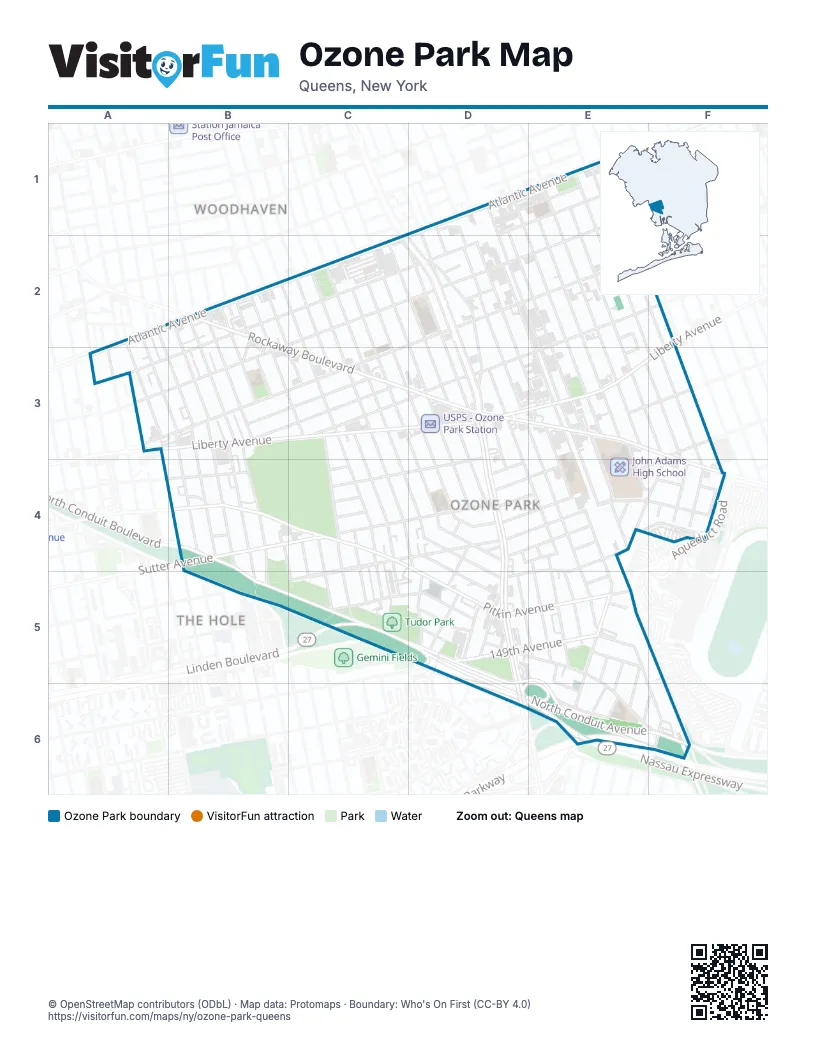
Street index of Ozone Park
Each street on the sheet and the grid squares it crosses.
- 100th StreetD1, E3, E4
- 101st StreetD1, E3, E4
- 102nd StreetD1, E3
- 94th AvenueD1, E1
- 95th AvenueD1, C2, D2, A3
- 95th StreetD1, D2, D3, D4, E4, E5
- 96th StreetD1, D2, D3, E4, E5
- 97th StreetD1, D2, D3, E4, E5
- Atlantic AvenueD1, A2, B2, C2, D2, A3
- 103rd StreetE1, E3, E4, F4
- 105th StreetE1, E2, E3, F3, F4
- 106th StreetE1, E2, E3, F3, F4
- 107th StreetE1, E2, F3, F4
- 97th AvenueE1, B2, C2, D2, E2, A3, B3
- 75th StreetA2, A3, B4
- 76th StreetA2, A3, B3, B4
- 77th StreetA2, A3, B3, B4
- 78th StreetB2, B3, B4
- 81st StreetB2, B3, B4, C5
- 82nd PlaceB2
- 82nd StreetB2, B3, C4, C5
- 83rd StreetB2, B3, C4, C5
- 84th StreetB2, C3, C4, C5
- 85th StreetB2, B3, C3, C4, C5
- 86th StreetB2, C2, C3, C4, C5
- Culloden PlaceB2, B3
- Digby PlaceB2, B3
- Rockaway BoulevardB2, C3, D3, E3, F3, F4
- 88th StreetC2, C3, C4, D4, D5
- 89th StreetC2, C3, D4
- 90th StreetC2, C3, D4
- 91st StreetC2, D3, D4
- 92nd StreetC2, D3, D4
- 93rd StreetC2, D2, D3, D4
- Woodhaven BoulevardC2, D2, D3
- 101st AvenueD2, A3, B3, C3
- 94th StreetD2, D3, D5, E5
- 98th StreetD2, E3, E4
- 99th AvenueD2
- 99th StreetD2, E3
- Woodhaven CourtD2
- 101st RoadE2
- 103rd RoadE2
- 104th StreetE2, E3
- 105th PlaceE2, E3
- Liberty AvenueF2, A3, B3, C3, D3, E3, F3
- Drew StreetA3
- Forbell StreetA3
- McKinley AvenueA3
- 102nd AvenueB3, C3
- 102nd RoadB3, C3
- 79th StreetB3, B4, B5
- 80th StreetB3, B4, B5
- 103rd AvenueC3, D3
- 87th StreetC3, C4, C5
- 107th AvenueD3, E3, C4, D4
- Cross Bay BoulevardD3, D4, D5, D6
- 103rd DriveE3
- 109th AvenueF3, C4, D4, E4
- Centreville StreetF3, F4, E5, E6
- Plattwood AvenueF3, D4, E4
- 75th Street;Ruby StreetB4
- Belmont AvenueB4
- Glenmore AvenueB4
- North Conduit AvenueB4, B5, C5, D5, E5, D6, E6, F6
- North Conduit BoulevardB4
- Pitkin AvenueB4, C4, D5, E5
- South Conduit AvenueB4, B5, D6
- South RoadB4
- Sutter AvenueB4, C4, D4, E4, F4
- 106th AvenueC4
- 108th AvenueC4, D4
- 133rd AvenueC4, D4, E4, C5
- 134th AvenueD4, E4
- 134th RoadD4, E4
- 94th PlaceD4
- Chicot RoadD4
- Desarc RoadD4, D5
- Doxsey PlaceD4
- Gold RoadD4, D5
- Rico PlaceD4
- Silver RoadD4
- Sitka StreetD4, D5
- 95th PlaceE4
- Boss StreetE4
- Hawtree StreetE4, E5, F6
- Linden BoulevardE4, C5, D5, E5
- Peconic StreetE4
- 108th StreetF4
- Aqueduct RoadF4, F6
- Muriel CourtF4
- Rosita RoadF4
- Dumont AvenueC5, D5
- 149th AvenueD5, E5
- Albert RoadD5, E5, E6, F6
- Arion RoadD5
- Lafayette StreetD5
- Nassau ExpresswayD5, D6, E6
- Redding StreetD5
- Spritz RoadD5
- Van Wicklen RoadD5
- Whitelaw StreetD5
- 135th DriveE5
- 135th RoadE5
- 150th RoadE5, E6
- 96th PlaceE5
- Bristol AvenueE5
- Eckford AvenueE5
- Huron StreetE5, E6
- Raleigh StreetE5, E6
- Tahoe StreetE5, E6
- 99th PlaceE6, F6
- Belt ParkwayE6
- Cohancy StreetF6
Places on the map
- 80th Street
- 88th Street
- Acacia Cemetery
- Allstar Fabrication
- Aqueduct-North Conduit Avenue
- Bayside Cemetery
- C-Town
- C&C Autoworks
- Cap't Loui
- Centreville Playground
- Cherry Valley Marketplace
- Circle S Milk Farm
- City Fresh
- CVS Pharmacy
- Dollar Tree
- FDNY Engine 285/Ladder 142
- Flagstar bank
- Francisco Park Hill Funeral Home
- High School for Construction Trade, Engineering and Architechture (Q650)
- John Adams High School
- Key Food
- Liberty Star Deli
- Link Homecare
- London Planetree Playground
- M.S. 137 - America's School of Heroes
- M.S. 210Q - Elizabeth Blackwell Middle School
- Marketplace Supermarket
- Masjid Al Jama
- Mokom Sholom Cemetery
- New Life Apostolic Church
- NYC DOT Facilities Maintence
- Ozone Park Branch Queens Borough Public Library
- P.S. 316Q - Queens Explorers Magnet School
- P.S. 377Q - S.T.A.R. Leadership Academy
- P.S. 63Q - Old South School
- P.S. 64Q - The Joseph P. Addabbo Magnet School
- Rockaway Boulevard
- Saint Mary Gate of Heaven Roman Catholic Church
- Southside Burial Ground
- Stop & Shop
Next to Ozone Park
- The Hole
- Woodhaven map
© OpenStreetMap contributors (ODbL) · Map data: Protomaps · Boundary: Who's On First (CC-BY 4.0)