

New York map
Prospect Heights map
A printable two-page map of Prospect Heights (Brooklyn, New York), drawn by VisitorFun from OpenStreetMap. Page two is the street index: every street on the sheet with its grid square, the same list as below.
Open the map (PDF, US Letter)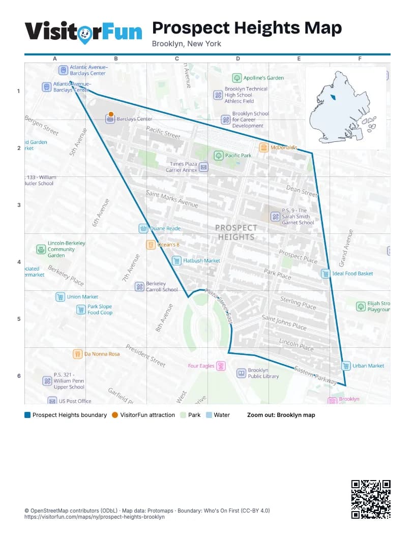
Street index of Prospect Heights
Each street on the sheet and the grid squares it crosses.
- Atlantic AvenueA1, B1
- 6th AvenueB1, B2
- Cumberland StreetC1
- Bergen StreetB2, C2
- Dean StreetB2, C2, D2
- Pacific StreetB2, C2, D2, E2
- Carlton AvenueC2, C3, C4
- Clermont AvenueD2
- Vanderbilt AvenueD2, D3, D4
- Clinton AvenueE2
- Underhill AvenueE2, E3, E4, D5, E5, D6
- Washington AvenueE2, E3, E4
- Prospect PlaceB3, C3
- Saint Marks AvenueB3, C3
- 7th AvenueC3
- Flatbush AvenueC3, C4, C5
- 8th AvenueC4
- Sterling PlaceC4, D4
- Park PlaceD4
- Plaza Street EastC5, D5, D6
- Plaza Street WestC5
- Saint Johns PlaceC5, D5
- Butler PlaceD5
- Lincoln PlaceD5
- Grand AvenueF5
- Eastern ParkwayD6, E6
- Eastern Parkway Service RoadD6, E6
- North Service RoadE6
Things to do on the Prospect Heights map
Places on the map
- 7th Avenue
- Atlantic Yards
- Barclays Center
- Bergen Street
- Church of God Victory
- Co-Cathedral of St. Joseph
- CubeSmart
- Duryea Presbyterian Church
- FDNY Engine 219/Ladder 105
- Flatbush Market
- Foodtown
- Grand Army Plaza
- Ideal Food Basket
- Latin Evangelical Free Church
- Mahfood Market
- Mayflower Sales
- McDonald's
- NYPD 78th Precinct
- P.S. 9 - The Sarah Smith Garnet School
- Pacific Park
- Prospect Heights Community Farm
- Temple of Restoration
- Times Plaza Carrier Annex
- Ultimate Auto Repair & Sales
© OpenStreetMap contributors (ODbL) · Map data: Protomaps · Boundary: Who's On First (CC-BY 4.0)