

New York map
Ridgewood map
A printable two-page map of Ridgewood (Queens, New York), drawn by VisitorFun from OpenStreetMap. Page two is the street index: every street on the sheet with its grid square, the same list as below.
Open the map (PDF, US Letter)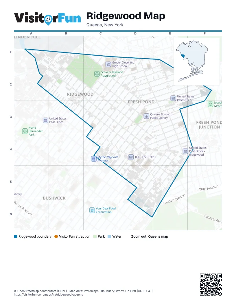
Street index of Ridgewood
Each street on the sheet and the grid squares it crosses.
- Flushing AvenueA1, B1, A2
- Metropolitan AvenueA1, B1, C1, D1
- Onderdonk AvenueA1, A2, B2, D4, E4
- Woodward AvenueA1, B1, B2, C2, E4
- Charlotte StreetB1
- Starr StreetB1
- Troutman StreetB1
- 55th StreetC1
- Amory CourtC1
- Grandview AvenueC1, C2, D2, D3
- Himrod StreetC1, D1, C2
- Nurge AvenueC1
- Rene CourtC1
- Tonsor StreetC1, D2
- 56th StreetD1
- 60th LaneD1, E3, E4
- 60th PlaceD1, D2, E3
- 60th StreetD1, D2, E3, E4
- 61st StreetD1, E2
- Eliot AvenueD1
- Forest AvenueD1, D2, D3, E4, E5
- Greene AvenueD1, C2, D2, C3
- Harman StreetD1, D2, C3
- Bleecker StreetE1, D2
- Randolph StreetA2
- Seneca AvenueA2, B2, D4, E5
- DeKalb AvenueB2, B3
- Hart StreetB2
- Suydam StreetB2
- Willoughby AvenueB2
- Fairview AvenueC2, D3
- Ricard StreetC2, D2
- Stanhope StreetC2, B3
- Stockholm StreetC2, B3
- Butler AvenueD2
- Gates AvenueD2, E2, F2, D3, C4
- Grove StreetD2, E2, C3, C4
- Korean SquareD2
- Linden StreetD2, E2
- Menahan StreetD2, E2
- 64th StreetE2, F2
- Bunnecke CourtE2
- Fresh Pond RoadE2, F4
- Palmetto StreetE2, F2, D3, C4
- Traffic AvenueE2, F2
- Woodbine StreetE2, F2, D3, C4
- Madison StreetF2, D3, E3
- Saint John RoadC3, D3
- 67th AvenueD3, E3
- 68th AvenueD3, E3
- Cornelia StreetD3, D4, C5
- Putnam AvenueD3, E3, D4
- 68th RoadE3, D4
- Catalpa AvenueE3, D4, E4
- Kleupfel CourtE3
- Stier PlaceE3
- Cypress AvenueC4, D4, D5, E5
- Myrtle AvenueC4, D4, E4, F4
- Saint Nicholas AvenueC4
- 69th AvenueD4
- 70th AvenueD4
- Centre StreetD4, E4, D5
- George StreetD4, E4, D5
- Hancock StreetD4, D5
- Jefferson AvenueD4
- Weirfield StreetD4, D5
- 71st AvenueE4, F4
- Decatur StreetE4, E5, D6
- Norman StreetE4, D5, E5
- Stephen StreetE4, D5
- Summerfield StreetE4, D5, E5
- Covert StreetD5
- Eldert StreetD5, D6
- Halsey StreetD5
- Schaefer StreetD5, D6
- Wyckoff AvenueD5, D6, E6
- 75th AvenueE5
- Cody AvenueE5, E6
- Saint Felix AvenueE5
- Cooper AvenueD6, E6
- Irving AvenueD6
Places on the map
- Agape Christian Center
- Ahawith Chesed Cemetery
- Associated Market Place
- AutoZone
- B & D Auto Collision
- Biedronka
- Burlington
- C-Town
- Checos Food Universe
- City Fresh Market
- Clemens Triangle
- Covenant Lutheran Church
- CTown Farmer’s Market
- Descent of the Holy Spirit Orthodox Church
- Equalatin Express
- Evangelical Fellowship Chapel
- Extra Space Storage
- First Romanian Baptist Church
- Food Bazaar Supermarket
- Forest Avenue
- Fresh & Save
- Fresh Pond Bus Maintenance Facility
- Good Neighbors Supermarket
- Grover Cleveland Athletic Field
- Grover Cleveland High School
- Grover Cleveland Playground
- Halsey Street
- Himalaya Food Market
- I.S. 77Q - Joseph F. Quinn Intermediate School
- I.S. 93Q - Ridgewood Intermediate School
- Iglesia Cristiana Bethel
- Junior's Food Outlets
- Liberty Department Stores
- Linden Hill Cemetery
- Mattress Firm
- Notre Dame Catholic Academy
- P. 75Q - The Robert E. Peary School
- P.S. 239Q - Police Officer Ramon Suarez School
- P.S. 290Q - A.C.E. Academy for Scholars at the Geraldine Ferraro Campus
- P.S. 71Q - Forest Elementary School
Next to Ridgewood
- Bushwick map
- Fresh Pond Junction
- Linden Hill
© OpenStreetMap contributors (ODbL) · Map data: Protomaps · Boundary: Who's On First (CC-BY 4.0)