

New York map
Shore Acres map
A printable two-page map of Shore Acres (Staten Island, New York), drawn by VisitorFun from OpenStreetMap. Page two is the street index: every street on the sheet with its grid square, the same list as below.
Open the map (PDF, US Letter)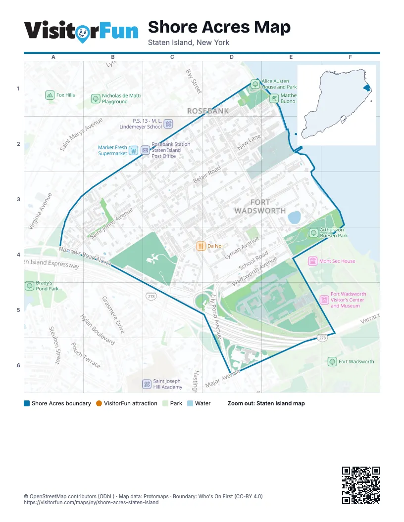
Street index of Shore Acres
Each street on the sheet and the grid squares it crosses.
- Abbott StreetD1, D2
- Andrease StreetD1, E1
- Bay StreetD1, D2, D3, E3, E4
- Maryland AvenueD1, C2, D2, A3, B3
- Waterview CourtD1, E1
- Scarboro AvenueE1, D2
- Hylan BoulevardB2, A3, B3
- Anderson StreetC2, D2
- Clayton StreetC2, C3
- Dayna DriveC2, C3
- Deal CourtC2, C3
- Saint Johns AvenueC2, D2, B3, C3, A4, B4
- Tompkins AvenueC2, C3, C4, D4, D5, D6
- Vermont AvenueC2
- Wingham StreetC2
- Anchor PlaceD2
- Belair RoadD2, C3, D3
- Courtney LoopD2, E2
- Keeley StreetD2
- New LaneD2, E2
- White StreetD2
- Cliff CourtE2
- Cliff StreetE2, D3, E3
- Nautilus StreetE2, D3
- Search LaneE2, D3
- U.S. Coast Guard - Station New YorkE2
- Colton StreetA3, B4
- Kay PlaceA3
- Maryland PlaceA3, B3
- Altavista CourtB3
- Beethoven StreetB3, C3, C4
- Bellavista CourtB3
- Fox Hill TerraceB3
- James PlaceB3, C3
- Reynolds StreetB3
- Schubert StreetB3, B4
- Thompson PlaceB3, C3
- Wagner StreetB3
- Belair LaneC3, D3
- Cabot PlaceC3
- Egbert PlaceC3, D3, D4
- Hope AvenueC3, D3, C4
- Hope LaneC3, D3, C4
- Seth LoopC3, D3
- Wilton CourtC3, C4, D4
- Bang TerraceD3
- Evelyn PlaceD3
- Fingerboard RoadD3, C4, D4, C5
- Home AvenueD3
- Summer StreetD3, D4
- Harborview PlaceE3
- High StreetE3, D4
- Polk WalkE3
- Sea Gate RoadE3, E4
- Shore Acres RoadE3
- Wadsworth RoadE3
- Donley AvenueA4
- Narrows Road NorthA4, B4, C5
- Hillbrook CourtB4
- Hilldale CourtB4
- Hillridge CourtB4
- Hillwood CourtB4
- Mendelsohn StreetB4
- North DriveB4
- Rubenstein StreetB4
- Strauss StreetB4
- Brown PlaceC4
- Fillmore PlaceC4
- Garfield AvenueC4, C5
- Harvey StreetC4, C5
- Merle PlaceC4
- Meyer LaneC4
- Bridge CourtD4
- Dennis Torricelli Senior StreetD4
- Judith CourtD4
- Lily Pond AvenueD4, D5, D6
- Lincoln AvenueD4, D5
- Lyman AvenueD4, E4
- School RoadD4, E4, D5
- Wadsworth AvenueD4, E4, D5
- Coast Guard DriveE4, D5
- New York AvenueE4, F5
- North RoadE4, F4
- Lincoln PlaceC5, D5
- Drum RoadD5, E5
- Major AvenueD5, E5, F5, D6, E6
- Maloney DriveD5, E5
- Marshall RoadD5, E5, F5
- Staten Island ExpresswayD5, E5, D6, E6
- Artillery RoadE5
- Verrazzano-Narrows BridgeE5, F5, E6
- Tompkins StreetF5
- Duer AvenueD6
- Narrows Road SouthD6
- HOV LaneE6
Places on the map
- 5 Fingerboard Gas Corp.
- Alice Austen House
- Alice Austen House and Park
- Arthur von Briesen Park
- Bagels by the Bay
- Bay Cigars & Tobacco
- Bay Plaza Gardens
- Bay St Deli & Grocery
- Bay Street & Fingerboard Road
- Bay Street & Hylan Boulevard
- Bay Street & New Lane
- Bay Street & Sea Gate Road
- Bay Street & Wadsworth Avenue
- Bay Street Dollar & Up Super Store
- Bay Street Tavern
- Be Yoga & Dance
- Bella Bean's Cafe
- Bloom Cafe
- Buzzy B Daycare
- Captain of the Port
- Chateau Villa
- Clifton Lake
- Coast Guard Pier
- Da Noi
- De Luca General Store
- Don Cheech
- Eagles Adult Day
- East Shore Little League
- El Cántarito Feliz
- Father Capodanno Memorial Chapel
- FDNY Engine 152 & Battalion 21
- Good Faith Adult Day Care Center
- Grasmere Estates
- Hills North
- Hylan Boulevard & Donley Avenue
- Hylan Boulevard & Reynolds Street
- I Smoke
- J&A In & Out Deli & Grill
- Joann's Deli
- John E. White Playground
Next to Shore Acres
© OpenStreetMap contributors (ODbL) · Map data: Protomaps · Boundary: Who's On First (CC-BY 4.0)