

New York map
South Beach map
A printable two-page map of South Beach (Staten Island, New York), drawn by VisitorFun from OpenStreetMap. Page two is the street index: every street on the sheet with its grid square, the same list as below.
Open the map (PDF, US Letter)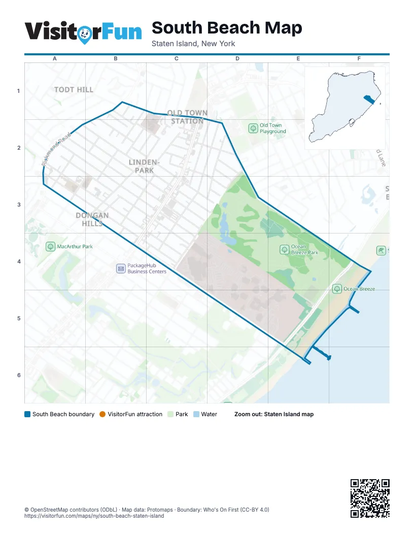
Street index of South Beach
Each street on the sheet and the grid squares it crosses.
- Albright StreetB1
- Dellwood RoadB1
- Divine StreetB1, B2
- Old Town RoadB1, C1
- Richmond RoadB1, A2
- Savin CourtB1
- Vista AvenueB1
- Whitaker PlaceB1, B2
- Wilson StreetB1, B2
- Carmel CourtC1, C2
- Durgess StreetC1
- North Railroad AvenueC1, B2, C2, B3
- Providence StreetC1
- Alter AvenueA2, B3, C3, C4
- Burgher AvenueA2, B2, C2, C3, D3
- Cromwell AvenueA2, B3, C4
- Delaware AvenueA2, B2, B3, C3, C4
- Delaware StreetA2
- Garretson AvenueA2, B3, B4, C4
- Plattsburg StreetA2
- Atlantic AvenueB2, B3, C3
- Bank PlaceB2
- Bear StreetB2, B3
- Cornelia StreetB2, C2
- Evergreen AvenueB2, C2, C3, D3
- Jefferson StreetB2, A3
- Johnson PlaceB2
- Mark StreetB2
- Minna StreetB2, C2
- Newberry AvenueB2
- Raritan AvenueB2, B3, C3
- Remsen StreetB2
- Adele StreetC2, C3
- Bath AvenueC2
- Benton AvenueC2, D2, D3
- Cooper AvenueC2
- Dumont AvenueC2
- Henry PlaceC2, B3
- Hylan BoulevardC2, B3, C3, B4
- Jerome RoadC2, D2, C3
- Laconia AvenueC2, D2, C3, C4
- Oregon RoadC2
- Reid AvenueC2, D2
- South Railroad AvenueC2
- Cameron AvenueD2
- Hurlbert StreetD2, D3
- Mason AvenueD2, C3, D3, C4
- Quintard StreetD2, D3, E3
- Ruth PlaceD2
- Xenia StreetD2, D3
- Hancock StreetB3
- Magnolia AvenueB3
- Perine AvenueB3
- Appleby AvenueD3
- McDermott AvenueD3
- Nugent AvenueD3, C4
- Scott AvenueD3
- Olympia BoulevardE3, D5
- Patterson AvenueE3, D5
- Seaview AvenueB4, C4, C5, D5, E5
- DEA CourtC4
- Simpson StreetC4
- Father Capodanno BoulevardE4, F4, E5
- Quincy AvenueD5
- Oceanside AvenueE5
Places on the map
- Al Watan Halal Market
- Asian Market
- Billiou-Stillwell-Perine House
- Carmel Apartments
- Carmel Richmond
- Cromwell Arms
- Dongan Hills
- Fishing Pier
- Lot 5
- Lot 6
- Ocean Breeze
- Ocean Breeze Park
- Ocean Breeze Track & Field Athletic Complex
- P.S. 11 - Thomas Dongan School
- Saint Ann Catholic Church
- Saint Ann School
- Staten Island Children and Youth Day Treatment Center and South Beach Psychiatric Center
- Staten Island University Hospital
- Steps 2 Success IV
Next to South Beach
© OpenStreetMap contributors (ODbL) · Map data: Protomaps · Boundary: Who's On First (CC-BY 4.0)