

New York map
South Corona map
A printable two-page map of South Corona (Queens, New York), drawn by VisitorFun from OpenStreetMap. Page two is the street index: every street on the sheet with its grid square, the same list as below.
Open the map (PDF, US Letter)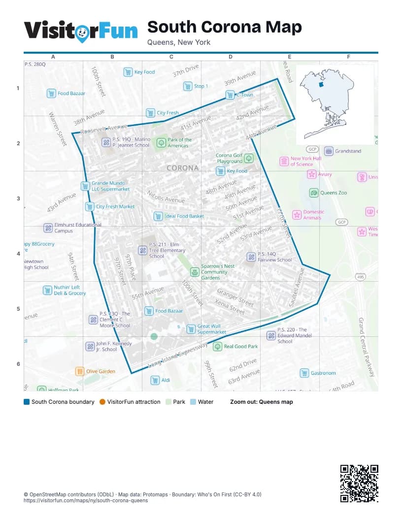
Street index of South Corona
Each street on the sheet and the grid squares it crosses.
- 108th StreetC1, D2, D3, D4, E4, E5
- Roosevelt AvenueC1, C2
- 111th StreetD1, D2, E2, E3, E4
- 112th StreetD1
- 114th StreetE1, E2
- 41st AvenueE1, B2, C2
- 42nd AvenueE1, B2, C2, D2
- 43rd AvenueE1, B2, C2, D2, B3
- 40th RoadA2, B2
- Junction BoulevardA2, B3, B4, B5
- 100th StreetB2, C4, C5, D5
- 102nd StreetB2, C2, C3, C4, D4, D5
- 97th PlaceB2, B3, B4, B5, C5
- 97th StreetB2, B3, B4, B5
- 98th StreetB2, B3, C5
- 99th StreetB2, B3, C3, C4, C5, C6
- National StreetB2, C2, B3
- Spruce StreetB2
- 103rd StreetC2, C3, C4, D4
- 104th StreetC2, C3, D4
- 44th AvenueC2, D2, E2, B3, C3
- 45th AvenueC2, D2, B3, C3
- 109th StreetD2
- 46th AvenueD2, B3, C3
- 47th AvenueD2, C3
- 48th AvenueE2, C3, D3
- Grand Central ParkwayE2
- 98th PlaceB3, C5
- Alstyne AvenueB3, C3, B4, D4
- Corona AvenueB3, C3, D3, B4, D4, E4, F4
- Nicolls AvenueB3, C3
- 49th AvenueC3, D3, E3
- 106th StreetD3, D4
- 50th AvenueD3, E3, B4, C4
- 51st AvenueD3, E3, B4, C4, D4
- 52nd AvenueD3, E3, D4
- 53rd AvenueE3, D4
- 96th StreetB4, B5
- Christie AvenueB4, C4
- 101st StreetC4, D5
- Lewis AvenueC4, D4, C5
- Radcliff AvenueC4
- Strong AvenueC4, D4
- 105th StreetD4
- 54th AvenueD4, E4
- Larue AvenueD4
- Martense AvenueD4, D5
- Otis AvenueD4, E4, D5
- Penrod StreetD4, D5, E5
- Van Cleef StreetD4, E4
- Van Doren StreetD4, E5
- Waldron StreetD4, E5
- 55th AvenueE4, B5, C5
- 56th AvenueE4
- Saultell AvenueE4, E5
- Westside AvenueE4, D5, E5
- 57th AvenueB5, C5, D5
- 58th AvenueC5, D5, B6
- 59th AvenueC5, D5, B6
- 60th AvenueC5, D5, B6
- Calloway StreetD5
- Granger StreetD5, E5
- Horace Harding ExpresswayD5, E5, F5, B6, C6, D6
- Long Island ExpresswayD5, E5, B6, C6, D6
- Xenia StreetD5
Places on the map
- 101 Brothers Auto Repair
- 102 St. Bodega
- 103rd Street-Corona Plaza
- 103rd Street–Corona Plaza
- 106 St Tire
- 108 Deli & Grocery
- 108 Discount II
- 108 Niños Corp.
- 108 Pharmacy
- 108th Street & 45th Avenue
- 108th Street & 46th Avenue
- 108th Street & 49th Avenue
- 108th Street & 51st Avenue
- 108th Street & 53rd Avenue
- 108th Street & Corona Avenue
- 108th Street & Horace Harding Expressway
- 108th Street & Martense Avenue
- 108th Street & Otis Avenue
- 108th Street & Penrod Street
- 108th Street & Van Cleef Street
- 108th Street & Waldron Street
- 108th Street Lumber
- 111st Street
- 111th Street
- 21st Century Pharmacy
- 3G Service Station
- 49 Rose Grocery
- 5 De Mayo
- 5 Stars Esthetic & Beauty
- 57th Avenue & 97th Street
- 57th Avenue & 98th Street
- 57th Avenue & 99th Street
- 60th Avenue & 99th Street
- 7-Eleven
- 99¢ & Plus
- 99th Street & 55th Avenue
- 99th Street & 58th Avenue
- A & G Clothing Store
- A.L. Fashion
- Acosta Food Stop
© OpenStreetMap contributors (ODbL) · Map data: Protomaps · Boundary: Who's On First (CC-BY 4.0)