

New York map
Springfield Gardens map
A printable two-page map of Springfield Gardens (Queens, New York), drawn by VisitorFun from OpenStreetMap. Page two is the street index: every street on the sheet with its grid square, the same list as below.
Open the map (PDF, US Letter)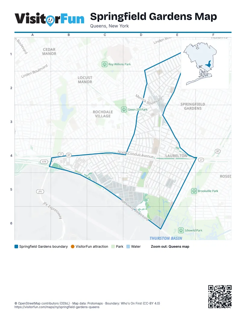
Street index of Springfield Gardens
Each street on the sheet and the grid squares it crosses.
- 120th AvenueD1, E1
- 120th RoadD1, D2
- 189th StreetD1
- 190th StreetD1
- 191st StreetD1, E2
- 192nd StreetD1, E2
- Lucas StreetD1, E2
- 121st AvenueE1, D2
- 122nd AvenueE1, D2, E2
- 193rd StreetE1, E2
- 194th StreetE1, E2
- 195th StreetE1
- 196th StreetE1
- 197th StreetE1, E2
- 198th StreetE1
- 199th StreetE1
- 200th StreetE1
- 201st PlaceE1
- 201st StreetE1
- 202nd StreetE1
- 203rd StreetE1
- Nashville BoulevardE1, D2, E2
- Springfield BoulevardE1, E2, E3, D4, E4, D5
- 131st AvenueD2, E2
- 180th StreetD2, D3, D4
- Belknap StreetD2, D3
- Benton StreetD2, E2
- Farmers BoulevardD2, D3, C4, D4, C5
- Grayson StreetD2, E2
- Mars PlaceD2
- Mathewson CourtD2, D3
- Merrick BoulevardD2, E2
- Milburn StreetD2, E2
- Montauk StreetD2
- Nellis StreetD2, E2
- Sidway PlaceD2
- Williamson AvenueD2, E2
- 135th AvenueE2, D3
- Adair StreetE2
- Defoe StreetE2
- Nepton StreetE2
- Pineville LaneE2
- Ridgedale StreetE2
- 132nd AvenueD3
- 133rd AvenueD3
- 134th AvenueD3
- 136th AvenueD3, E3
- 137th AvenueD3, E3
- 138th AvenueD3, E3
- 139th AvenueD3, E3
- 139th RoadD3
- 140th AvenueD3, E3
- 141st AvenueD3, E3, E4
- 181st StreetD3, D4, D5
- 182nd StreetD3, D4, D5
- 183rd StreetD3, D4, D5
- 184th StreetD3, D4, D5
- 185th StreetD3, D4
- Bedell StreetD3
- Bennett CourtD3
- Bennett StreetD3
- Cheney StreetD3
- Coombs StreetD3
- Crandall AvenueD3
- Denis StreetD3
- Eastgate PlazaD3, E3
- Edgewood AvenueD3, E4
- Garrett StreetD3
- Sloan StreetD3, E3
- Southgate PlazaD3
- Southgate StreetD3
- Thurston StreetD3
- Westgate StreetD3
- 137th RoadE3
- 138th RoadE3
- 219th StreetE3, E4
- 222nd StreetE3, E4, D5
- Carson StreetE3, E4
- JFK ExpresswayA4, B4
- 144th AvenueB4, C4, D4, E4
- 145th AvenueB4, C4, D4, E4, E5
- 145th RoadB4, C4, D4, C5, D5, E5
- 146th AvenueB4, D4, B5, C5, D5, E5
- 153rd CourtB4
- 153rd LaneB4
- 153rd PlaceB4
- 155th StreetB4
- 156th StreetB4
- 157th StreetB4
- 158th StreetB4
- 159th StreetB4, C4, B5
- Belt ParkwayB4, C4, D4, E4
- Nassau ExpresswayB4, B5, C5
- Rockaway BoulevardB4, C4, C5, D5, D6
- South Conduit AvenueB4, C4, D4, E4
- 144th DriveC4
- 144th RoadC4, D4
- 144th TerraceC4
- 145th DriveC4, D4, C5, D5
- 166th StreetC4
- 167th StreetC4, C5
- 168th StreetC4, C5
- 175th StreetC4, C5
- 176th StreetC4, C5
- 177th PlaceC4
- 177th StreetC4, C5
- BroadwayC4
- Guy R. Brewer BoulevardC4, C5, D5
- Meadow DriveC4
- Meadow RoadC4
- 142nd AvenueD4
- 143rd AvenueD4, E4
- 143rd RoadD4, E4
- 178th PlaceD4, D5
- 179th StreetD4, D5
- 181st PlaceD4
- 182nd PlaceD4
- 220th StreetD4, D5
- 221st StreetD4, E4, D5
- Arthur StreetD4
- North Conduit AvenueD4, E4, F4
- 141st RoadE4
- 142nd RoadE4
- 223rd StreetE4, D5
- 224th StreetE4, D5
- 225th StreetE4, D5, E5
- 226th StreetE4, D5, E5
- 227th StreetE4, E5
- 228th StreetE4, E5
- 229th StreetE4, E5
- 230th PlaceE4, E5
- 230th StreetE4, E5
- Lansing AvenueE4
- Prospect CourtE4
- 146th DriveC5, D5
- 146th RoadC5, D5
- 146th TerraceC5, D5
- 147th AvenueC5, D5, E5
- 148th AvenueC5, D5, E5
- 148th RoadC5
- 149th AvenueC5, D5, E5
- 149th RoadC5, D5
- 150th AvenueC5, D5
- North Hangar RoadC5
- Porter RoadC5
- 150th DriveD5
- 150th RoadD5
- James Brown PlaceD5
- North Boundary RoadD5
- Pleasant PlaceD5
- Springfield LaneD5
- Eastern RoadD6
- International Airport Center BoulevardD6, E6
Places on the map
- Bartlett Dairy
- BP
- Community Bridge Home
- Dollar Tree
- Extra Space Storage
- Fine Fare
- I.S. 59Q
- JFK Logistics Center
- McDonald's
- Mobil
- Montbellier Park
- New Apostolic Church
- P.S. 15Q - The Jackie Robinson School
- P.S. 181Q - The Brookfield School
- P.S. 37Q - The Cynthia Jenkins School
- P.S. 52Q
- Saint Peter's Lutheran Church
- Saratoga Family Inn
- Springfield Gardens Educational Campus
- Springfield Park
- Springfield Pond
- Stop & Shop
- The Garden of Resilience
- The Home Depot
Next to Springfield Gardens
- Cedar Manor
- Cedar Manor Houses
- Locust Manor
- Rochdale Village
- Rosedale map
© OpenStreetMap contributors (ODbL) · Map data: Protomaps · Boundary: Who's On First (CC-BY 4.0)