

New York map
Sunnyside map
A printable two-page map of Sunnyside (Queens, New York), drawn by VisitorFun from OpenStreetMap. Page two is the street index: every street on the sheet with its grid square, the same list as below.
Open the map (PDF, US Letter)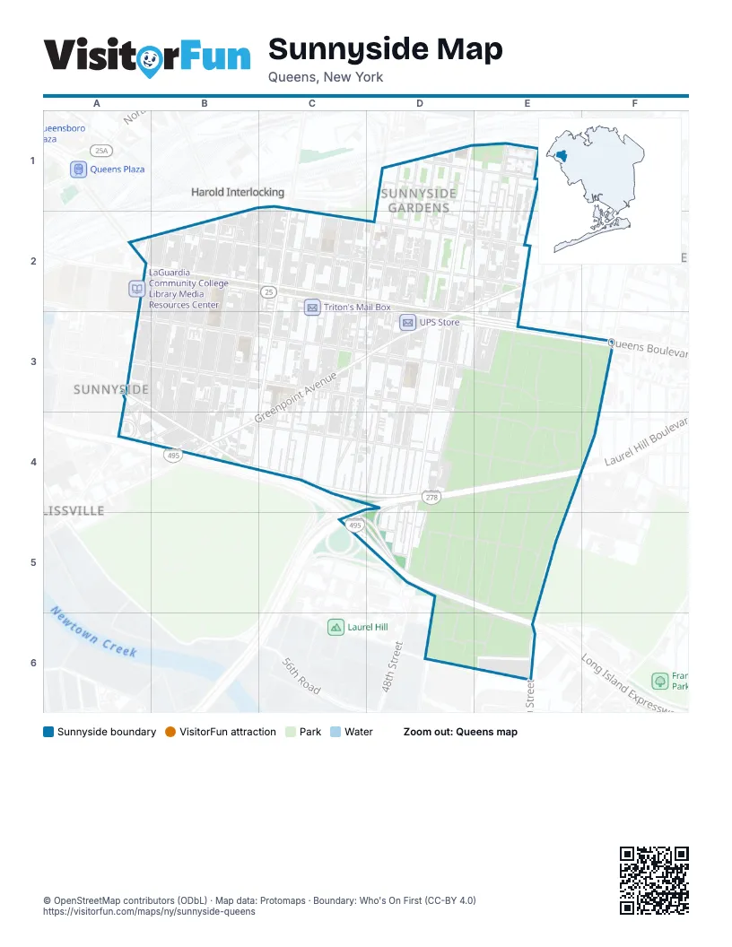
Street index of Sunnyside
Each street on the sheet and the grid squares it crosses.
- 37th StreetB1, B2, B3, B4
- 38th StreetC1, C2, B4
- Skillman AvenueC1, B2, C2, D2, E2
- 39th AvenueD1, E1
- 43rd StreetD1, C2, D2, C3, C4
- 44th StreetD1, D2, D3, C4
- 45th StreetD1, D2, D4
- 46th StreetD1, D2, D3, D4, D5
- 47th StreetD1, D2, D5
- 48th StreetD1, D2, D3, D5
- Barnett AvenueD1
- 39th RoadE1
- 49th StreetE1, D2, E2, D3, D4
- 50th StreetE1, E2, D3
- 51st StreetE1, E2, E3
- 52nd StreetE1, E2, E3
- Queens BoulevardA2, B2, C2, D2, D3, E3
- Thomson AvenueA2, B2
- Van Dam StreetA2, A4
- 32nd PlaceB2, A3, A4
- 33rd StreetB2, B4
- 34th StreetB2, A4, B4
- 35th StreetB2, B3, B4
- 36th StreetB2, B4
- 43rd AvenueB2, C2, D2, E2
- Honeywell StreetB2
- 39th PlaceC2, C3, C4
- 39th StreetC2, B4
- 40th StreetC2, C3, C4
- 41st StreetC2, C3, C4
- 42nd StreetC2, C3, C4
- Roosevelt AvenueD2, E2, D3
- 39th DriveE2
- Gale AvenueA3, A4, B4
- Hunters Point AvenueA3, B4
- 47th AvenueB3, D3, E3
- 48th AvenueB3, D3
- Greenpoint AvenueC3, D3, B4, C4
- Boundary AvenueD3, D4, E4, D5, E5
- Saint Boniface AvenueD3, D4, E4
- Saint Francis AvenueD3, E3
- 54th StreetE3
- Saint Lawrence AvenueE3, E4, D5, E5
- Saint Michael AvenueE3, E4
- Saint Patrick AvenueE3, F3, D4, E4, F4
- 56th StreetF3
- 58th StreetF3, F4, E5, E6
- 50th AvenueB4, C4, D4
- Borden AvenueB4
- Laurel Hill BoulevardB4, C4, D4, D5
- Celtic AvenueC4
- Queens-Midtown ExpresswayC4, D4
- Brooklyn-Queens ExpresswayD4, C5
- Saint James AvenueD4, D5
- Saint Anne AvenueE4, E5
- Saint Bridget AvenueE4, E5
- Saint Veronica AvenueE4
- Saint Vincent de Paul AvenueE4, E5
- 58th PlaceF4
- Long Island ExpresswayC5, D5, E5, E6
- 51st RoadD5
- 54th AvenueD5
- Saint Aloysius AvenueD5, D6
- Saint Cecilia AvenueD5
- Saint Matthew AvenueD5, D6, E6
- Saint William AvenueD5, E5
- Saint Theresa AvenueD6, E6
- Saint Mark AvenueE6
Places on the map
- 33rd Street-Rawson Street
- 40th Street-Lowery Street
- 45th Street Composters
- 46th Street-Bliss Street
- 52nd Street-Lincoln Avenue
- Aviation High School
- BMW Of long Island City
- Butcher Block
- Celtic Park
- Citgo
- Citibank
- City Ice Pavilion
- Dainobu
- Edward D. Lynch Funeral Home
- Enterprise
- FDNY Engine 325/Ladder 163
- Food Universe
- Fourth Calvary Cemetery
- Fresh n Save
- Fresh N' Save Supermarket
- Global
- Good Neighbors Sunnyside
- Green Valley Marketplace
- I.S. 125 - Thomas J. McCann Woodside Intermediate School
- Jefferson Court
- La Quinta Inn
- McDonald's
- Mobil
- N.Y. Nam Presbyterian Church
- P.S. 150Q
- P.S. 199Q - Maurice A. FitzGerald School
- Parrot Coffee Market Place
- Phipps Garden Apartments
- Queen of Angels Roman Catholic Church
- Queens Assembly Hall of Jehovahs Witnesses
- Queens Library - Sunnyside Branch
- Queens Technical High School
- Saint Raphael's Roman Catholic Church
- Saint Teresa's Roman Catholic Church
- Sculpture Space NYC
Next to Sunnyside
- Blissville
- Harold Interlocking
- Woodside map
© OpenStreetMap contributors (ODbL) · Map data: Protomaps · Boundary: Who's On First (CC-BY 4.0)