

New York map
Upper East Side map
A printable two-page map of Upper East Side (Manhattan, New York), drawn by VisitorFun from OpenStreetMap. Page two is the street index: every street on the sheet with its grid square, the same list as below.
Open the map (PDF, US Letter)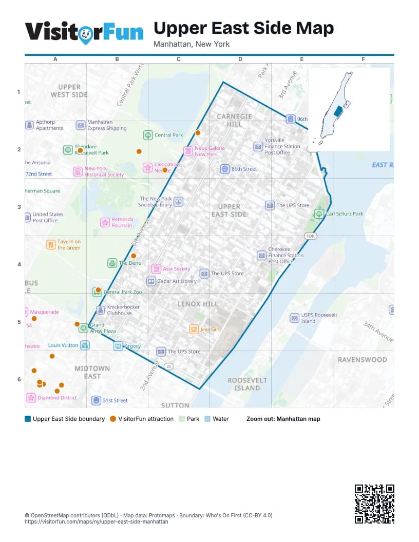
Street index of Upper East Side
Each street on the sheet and the grid squares it crosses.
- 3rd AvenueD1, E1, D2, D3, C4, B5, C5
- East 93rd StreetD1, D2, E2
- East 94th StreetD1, D2, E2
- East 95th StreetD1, E1, E2
- East 96th StreetD1, E1, E2
- Lexington AvenueD1, D2, C3, C4, B5
- Madison AvenueD1, C2, D2, C3, B4, C4, B5
- Park AvenueD1, C2, D2, C3, B4, C4, B5
- 2nd AvenueE1, D2, E2, D3, C4, D4, C5, C6
- México-Tenochtitlan AvenueE1
- 5th AvenueC2, B4, B5
- 86th Street TransverseC2
- East 82nd StreetC2, C3, D3, E3, E4
- East 83rd StreetC2, D3, E3, E4
- East 84th StreetC2, E3
- East 85th StreetC2, D2, D3, E3
- East 86th StreetC2, D2, D3, E3
- East 87th StreetC2, D2, E3
- East 88th StreetC2, D2, E3
- East 89th StreetC2, D2, E2, E3
- East 90th StreetD2, E2, E3
- East 91st StreetD2, E2
- 1st AvenueE2, E3, D4, C5, D5, C6
- East 92nd StreetE2
- FDR DriveE2, E3, D4, E4, D5, C6, D6
- York AvenueE2, E3, D4, D5, C6
- East 73rd StreetB3, C4, D4, D5
- East 74th StreetB3, C4, D4, D5
- East 75th StreetB3, C4, D4
- 79th Street TransverseC3
- East 76th StreetC3, C4, D4, E4
- East 77th StreetC3, D4
- East 78th StreetC3, D4, E4
- East 79th StreetC3, D3, D4, E4
- East 80th StreetC3, D3, D4, E4
- East 81st StreetC3, D3, E4
- East End AvenueE3, E4
- Gracie SquareE3
- Henderson PlaceE3
- 65th Street TransverseB4
- East 65th StreetB4, C5, D5
- East 66th StreetB4, C5, D5
- East 67th StreetB4, C5, D5
- East 68th StreetB4, C5, D5
- East 69th StreetB4, C5, D5
- East 70th StreetB4, C4, D5
- East 71st StreetB4, C4, D5
- East 72nd StreetB4, C4, D5
- Terrace DriveB4
- Cherokee PlaceD4, E4
- Wayne Clark DriveD4
- Gracie TerraceE4
- East 59th StreetB5, C6
- East 60th StreetB5, C6
- East 61st StreetB5, C6
- East 62nd StreetB5, C5, C6
- East 63rd StreetB5, C5, C6, D6
- East 64th StreetB5, C5, D6
- Queensboro Bridge ExitC5, C6
- NewYork-Presbyterian Ambulance EntranceD5
- Special Surgery DriveD5
- Ed Koch Queensboro Bridge Lower LevelC6
- Ed Koch Queensboro Bridge Lower RoadwayC6
- Ed Koch Queensboro Bridge Upper LevelC6
- Queensboro Bridge Outer RoadwayC6
- Sutton PlaceC6
Things to do on the Upper East Side map
Places on the map
- (St. Catherine's Park Playground) Children's Play Area
- (Twenty-Four Sycamores Park Playground) Children's Play Area
- 1 Ave Gourmet Deli
- 1592 Grab & Go
- 16 Handles
- 1st Avenue & East 64th Street
- 1st Avenue & East 67th Street
- 1st Avenue & East 70th Street
- 1st Avenue & East 72nd Street
- 1st Avenue & East 75th Street
- 1st Avenue & East 77th Street
- 1st Avenue & East 79th Street
- 1st Avenue & East 83rd Street
- 1st Avenue & East 86th Street
- 1st Avenue & East 89th Street
- 1st Avenue & East 91st Street
- 1st Avenue & East 93rd Street
- 1st Avenue Wine & Spirits
- 2nd Ave Deli
- 2nd Avenue & East 61st Street
- 2nd Avenue & East 64th Street
- 2nd Avenue & East 66th Street
- 2nd Avenue & East 68th Street
- 2nd Avenue & East 70th Street
- 2nd Avenue & East 72nd Street
- 2nd Avenue & East 75th Street
- 2nd Avenue & East 78th Street
- 2nd Avenue & East 82nd Street
- 2nd Avenue & East 84th Street
- 2nd Avenue & East 86th Street
- 2nd Avenue & East 87th Street
- 2nd Avenue & East 89th Street
- 2nd Avenue & East 92nd Street
- 2nd Avenue & East 94th Street
- 2nd Avenue & East 96th Street
- 2nd Avenue Corner
- 2nd Floor Bar & Essen
- 2nd Heaven Organic
- 2nd STREET
- 3 Decker Restaurant & Cafe
Next to Upper East Side
- Midtown East map
- Ravenswood
- Roosevelt Island map
- Sutton
- Upper West Side map
© OpenStreetMap contributors (ODbL) · Map data: Protomaps · Boundary: Who's On First (CC-BY 4.0)