

Ohio map
Canton map
About 69,211 people live here (Census Bureau, 2024 estimate). The sheet's index lists 138 streets; Colonial Boulevard Northeast, Market Avenue North and Harmont Avenue Northeast cross the most grid squares. Things to do inside the boundary: Bender's Tavern, Canton Classic Car Museum and Canton Memorial Civic Center.
Open the map (PDF, US Letter)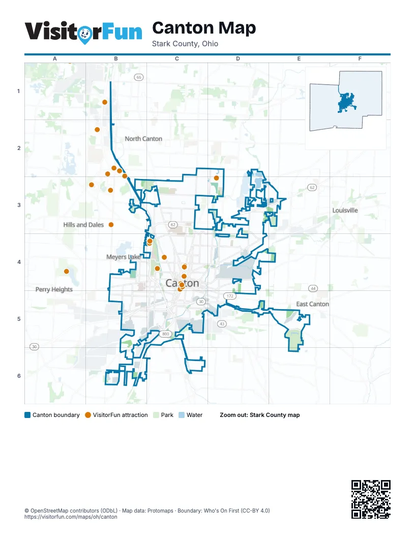
Street index of Canton
Each street on the sheet and the grid squares it crosses.
- Shuffel Street NorthwestB1
- Whipple Avenue NorthwestB2
- 55th Street NortheastC2
- 55th Street NorthwestC2
- Market Avenue NorthC2, C3, C4
- Harmont Avenue NortheastD2, D3, D4
- 38th Street NorthwestB3, C3
- 30th Street NorthwestC3
- 34th Street NorthwestC3
- 37th Street NorthwestC3
- 44th Street NortheastC3
- 44th Street NorthwestC3
- Cleveland Avenue NorthwestC3, C4
- Colonial Boulevard NortheastC3, D3, C4, D4
- Cromer Avenue NorthwestC3
- Frazer Avenue NorthwestC3
- Fulton Road NorthwestC3, C4
- Gibbs Avenue NortheastC3, C4
- Harrison Avenue NorthwestC3, C4
- Harvard Avenue NorthwestC3, C4
- Malone Parkway NorthwestC3
- Park DriveC3, C4
- South Main StreetC3
- 30th Street NortheastD3
- 34th Street NortheastD3
- Atlantic Boulevard NortheastD3, E3
- Columbus Road NortheastD3, E3
- Commercial Road NortheastD3
- Fairmount Boulevard NortheastD3, D4
- Harrisburg Avenue NortheastD3, D4
- Lesh Street NortheastD3, E3
- Plain Center Avenue NortheastD3
- Regent Avenue NortheastD3
- Spangler Street NortheastD3
- 12th Street NorthwestB4, C4
- 13th Street NorthwestB4, C4
- 3rd Street NorthwestB4
- 4th Street NorthwestB4, C4
- 6th Street SouthwestB4, C4
- Bedford Avenue SouthwestB4, B5
- Broad Avenue NorthwestB4
- Maryland Avenue SouthwestB4, B5
- Raff Road SouthwestB4, B5
- Tuscarawas Street WestB4, C4
- Wertz Avenue NorthwestB4
- 12th Street NortheastC4, D4
- 15th Street NortheastC4
- 15th Street NorthwestC4
- 17th Street NorthwestC4
- 19th Street NortheastC4, D4
- 25th Street NorthwestC4
- 2nd Street NortheastC4
- 2nd Street NorthwestC4
- 2nd Street SoutheastC4
- 2nd Street SouthwestC4
- 3rd Street NortheastC4, D4
- 3rd Street SoutheastC4, C5
- 3rd Street SouthwestC4
- 4th Street NortheastC4
- 5th Street NortheastC4, D4
- 5th Street NorthwestC4
- 6th Street NortheastC4, D4
- 6th Street NorthwestC4
- 7th Street NorthwestC4
- 9th Street NortheastC4
- 9th Street NorthwestC4
- Cherry Avenue NortheastC4
- Cherry Avenue SoutheastC4, C5
- Cleveland Avenue SouthwestC4, C5
- Dueber Avenue SouthwestC4, C5
- Harrison Avenue SouthwestC4, C5
- High Avenue NorthwestC4
- High Avenue SouthwestC4
- Lake Road Boulevard NorthwestC4
- Lawn Avenue NorthwestC4
- Lawrence Road NortheastC4
- Lincoln Avenue NorthwestC4
- Madison Court SoutheastC4, C5
- Mahoning Road NortheastC4, D4
- Market Avenue SouthC4, C5
- Mc Kinley Avenue SouthwestC4, C5
- McKinley Avenue NorthwestC4
- McKinley Avenue SouthwestC4
- Mercy Drive NorthwestC4
- Riverside Drive SoutheastC4, C5
- Rowland Avenue NortheastC4
- Shorb Avenue NorthwestC4
- Tuscarawas Street EastC4, D5
- Walnut Avenue NortheastC4
- Walnut Avenue SoutheastC4
- 25th Street NortheastD4
- 8th Street NortheastD4
- Belden Avenue NortheastD4, D5
- Georgetown Street NortheastD4
- Gilbert Avenue NortheastD4
- Ira Turpin Way NortheastD4
- Louisville Street NortheastD4
- Maple Avenue NortheastD4
- Marion Motley Avenue NortheastD4
- Midway Avenue NortheastD4
- Trump Avenue NortheastD4
- Warner Road SoutheastD4, C5
- 11th Street SouthwestB5, C5
- 13th Street SouthwestB5
- 15th Street SouthwestB5, C5
- 21st Street SouthwestB5
- 9th Street SouthwestB5, C5
- Casper Road SouthwestB5
- Clarendon Avenue SouthwestB5
- Gambrinus Avenue SouthwestB5
- Navarre Road SouthwestB5, C5
- 11th Street SoutheastC5
- 14th Street SoutheastC5
- 15th Street SoutheastC5
- 17th Street SoutheastC5
- 17th Street SouthwestC5
- 4th Street SoutheastC5, D5
- Allen Avenue SoutheastC5
- Allenford Drive SoutheastC5
- Bolivar Road SouthwestC5
- Central Avenue SoutheastC5, C6
- Mc Kinley Cut Thru Avenue SouthwestC5
- Mill Street SoutheastC5
- Mill Street SouthwestC5
- Shepler Church Avenue SouthwestC5, B6
- Sherrick Drive SoutheastC5
- Sherrick Road SoutheastC5
- Timken Place SouthwestC5
- Belden Avenue SoutheastD5
- Lincoln Street EastD5
- Marietta Avenue NortheastD5
- Roshong Avenue SoutheastD5
- Trump Avenue SoutheastD5
- Waynesburg Drive SoutheastD5
- Orchard View Drive SoutheastE5
- Pekin Drive SoutheastE5
- Faircrest Street SouthwestB6
- Sherman Church Avenue SouthwestB6
Things to do on the Canton map
Places on the map
- Akron Children's Hospital at Aultman
- Amazon Fulfillment Center
- Arboretum Park
- Avondale Arboretum
- Bauhoff Park
- Canton
- Canton Centre
- Canton Post Office
- Case Mansion Flats
- City Field Park
- Cleveland Clinic Mercy Hospital
- Cook's Lagoon
- Covered Bridge Park
- Crenshaw Junior High School
- Crenshaw Park
- Don Scott Field
- Fairhope Nature Preserve
- Forest Hill Cemetery
- Freeway Park
- Gage Gardens Apartments
- Gervasi Vineyard
- Glenwood Intermediate School
- Harmont Park
- Hartford Junior High School
- Harvard Park
- Herbruck Park
- Ida Park
- Jackson Park
- Madge Youtz Branch Stark County Library
- Mason Elementary School
- Mckinley Memorial Park
- Montabella Estates
- Nimisilla Park
- North Lawn Cemetery
- Oak Park
- Pilot Travel Center
- Pro Football Hall of Fame
- Republic Steel (8th Street Plant)
- Riverside Park
Next to Canton
- East Canton
- Hills and Dales
- Louisville
- Meyers Lake
- North Canton
- Perry Heights
© OpenStreetMap contributors (ODbL) · Map data: Protomaps · Boundary: Who's On First (CC-BY 4.0)