

Ohio map
Clayton map
About 13,296 people live here (Census Bureau, 2024 estimate). The sheet's index lists 300 streets; Diamond Mill Road, East Westbrook Road and North Main Street cross the most grid squares. Also on it: Meadowbrook at Clayton, Bethel Cemetery and Northwood Elementary School.
Open the map (PDF, US Letter)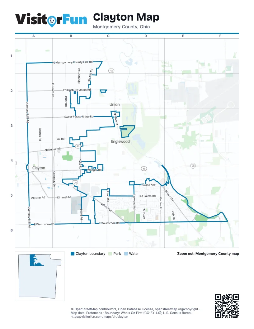
Street index of Clayton
Each street on the sheet and the grid squares it crosses.
- Salem AvenueB5, C5, C6
- North Main StreetC3, D5, E5, E6
- National RoadA4, B4
- Taywood RoadD5, D6
- Union RoadC5, C6
- Salem Bend DriveD6
- Diamond Mill RoadA1, A2, A3, A4, A5, A6
- East Westbrook RoadA6, B6, C6, D6, E6
- Sweet Potato Ridge RoadA3, B3, C3
- Phillipsburg Union RoadA2, B2, C2
- Crestway DriveB4, B5, B6
- Hoke RoadB4, B5, B6
- Kimmel RoadA5, B5
- Wenger RoadB4, C4
- Garber RoadD5, D6
- Talmadge RoadA4
- East Salem StreetA4, B4
- South Kimmel RoadA4, A5
- Dog Leg RoadE6
- West Salem StreetA4
- South Diamond Mill RoadA4, A5
- Philadelphia DriveF6
- Denlinger RoadD6
- Brookville Salem RoadA4
- South Old Mill RoadB3
- Haber RoadB1, B2, B3, B4
- Old Salem RoadC5, D5, E5
- North Montgomery County Line RoadA1, B1, C1
- Putnam RoadA1, A2, B2, B3
- Barnes RoadA3, A4
- Old Mill RoadC1, B2, C2
- Rinehart RoadB1, B2, B3
- Seville DriveC5, D5
- Honey Brook AvenueD5
- Clinton StreetA4, B5
- Fox RoadB3, A4
- Cheri Lynne DriveE5, E6
- Savina AvenueD5
- Southway RoadB5
- Wastler RoadA5
- Afton DriveD5, D6
- Noranda DriveD5, D6
- Shadywood DriveD5
- Woolery LaneE5
- Rushleigh RoadC5, D5
- Rangeview DriveD5, D6
- Freeport DriveD5, D6
- North Kimmel RoadA4
- Willow Creek DriveD6
- Crescent Ridge DriveC5
- Summersweet DriveC5, C6
- Morrow DriveD5
- Volk DriveE5, E6
- Valley Brook DriveC5
- Allison AvenueE5, E6
- Ashbrook RoadE5, E6
- Park Vista RoadC5
- Riverbend DriveF6
- Prospect AvenueE5, E6
- Dominican DriveD5
- Rundell DriveD5
- Northfield RoadD5
- Inwood AvenueE5
- Skylark DriveC5, D5
- Thelma AvenueD5, E5
- River Ridge RoadE5
- Springway DriveE6
- Kinsey RoadC5, D5
- Irvington AvenueE5, E6
- Hacker RoadE5
- Satellite AvenueD5
- Jay RoadB1
- Valley Brook Drive SouthC5
- Burkwood DriveC5, C6
- Crownwood AvenueD5
- Swan DriveA4
- Linchmere DriveD5, D6
- Janice PlaceD6
- Mintwood AvenueD5
- Elru DriveD5
- Scothills DriveC5
- Harrington AvenueE5, E6
- Heathcliff RoadD5, E5
- Hillgrove AvenueD5
- Pebble Brook DriveC5
- Robert Ulrich AvenueD5
- Baldwinhills DriveC5
- Greenbay DriveD5
- Shell AvenueD5
- Priscilla AvenueE6
- Barrington DriveE5, E6
- Elmway DriveE5
- Lockwood StreetD5
- West Mill StreetA4
- Springview LaneB4
- Sydenham DriveC5, D5
- Mount Royal DriveC6
- Melody RoadE5, E6
- Packingham DriveC5, D5
- Proaction DriveB4
- Coralberry DriveC5, C6
- Country View LaneB6
- Hilltop DriveD5
- Virginia Springs DriveB4
- Ranch Hill DriveD5
- Cilantro WayB4
- Flagler StreetD5, E5
- Lukmin CourtB4
- Rose Tree LaneA6, B6
- Rushwood CircleC5
- Stillmore DriveD5
- Templehurst DriveD5
- Dorchester DriveE5
- Rosser AvenueA5
- Sterling Woods DriveC5, C6
- Stranwood DriveD5
- Granite DriveE5
- Glenhills DriveC5
- Rathburn DriveC5, D5
- Golf CourseC6, D6
- Maynard AvenueD5
- Murray StreetA4
- Scenic River DriveF6
- Dawnwood DriveD5, E5
- Hoffman DriveE5
- Blue Teal DriveA4
- Colemere CircleD6
- Wetzel Farm RoadB4
- Deeter DriveC4
- Sunnyhills DriveC5
- Par DriveC6
- Roblarhills DriveC5
- Copperfield PlaceD5
- Oren RoadD6
- Pleasant Plain RoadA4
- East Greenview DriveE5
- Salem Crossing PlaceC5
- Gorman AvenueD5
- King Oak LaneE5
- Greenview DriveE5
- White Gates PlaceA5
- Oak Field DriveD5
- Anneliese WayB4
- Elin CourtD5
- Highfield DriveD5
- Portrait DriveD5
- Artistic CourtD5
- Water StreetA4
- Wenger MeadowsB4
- Baronsmere CourtD5
- Ellis AvenueD5, E5
- Rymark CourtD5
- Pacemont AvenueD5, E5
- Monte Carlo DriveC5
- Fairlawn CourtC5, D5
- Pineview DriveD5
- Cedar Bluff CircleD6
- Groveview AvenueE5
- Pineland TerraceD5
- Parsley PlaceB4
- Pineland TrailD5
- Marylew LaneE5
- Sheelin CourtD5
- Dill BoulevardB4
- Michelle PlaceD5
- Ridge Acres LaneB3
- Meiring StreetB4
- Molunat LaneB4
- Glenhaven RoadE5
- Remington AvenueE5
- West Martindale RoadB2
- Vinway CourtE5
- Willow Creek CourtD6
- Galaxie DriveD5
- Thundering Herd PlaceD5
- Northland CourtE6
- Good Samaritan BoulevardD5, E5
- Pugliese PlaceD5
- Valley Oak CourtE5
- Rose Bud WayD5
- Southview DriveC4
- Layne Hills CourtC5
- Fall Gold DriveC6
- Debbie CourtD6, E6
- Deville DriveD5
- Hill StreetA4
- Greenbank CourtD5
- Lavon CourtD5, D6
- Steineman StreetB4
- Whitaker PlaceD5
- Marjoram PlaceB4
- Tammy CircleE6
- McKenna PlaceD5
- Brushwood DriveD5, D6
- Northcreek DriveC4
- Gold Key BoulevardD5
- Laurel Fork RoadD5
- Bolzano BoulevardB4
- Stonewall CircleD6
- Fontella CourtD5
- Deubner DriveC3
- Sue LaneE6
- Colleen CourtD5
- Circle DriveE5
- Reeves CourtD5
- Flower AvenueE6
- Noranda CourtD5
- Caldero CourtD5
- Lisa Lee LaneE6
- Jacks LaneA5
- Rustic Oak DriveE5
- Borges StreetB4
- Cinnamon Tree CourtC5
- Wood Acre CourtC5
- Romaine DriveE6
- West Spring StreetA4
- Barley DriveE5
- East Mill StreetA4
- Jana CircleD5, E5
- Pepperton CourtD5
- Benjamin Franklin DriveC5
- Sterling MapleC6
- Trailway AvenueE5
- Damson DriveC5
- Enesco CourtC5
- Flaute StreetB4
- Spring StreetA4
- Silverbell CourtC6
- Wood Duck CourtA4
- Sand Pebble CourtC5
- Rahway CourtD5
- Golf Manor CourtC5
- Tuxford PlaceD5
- Countrydale CourtD5, D6
- Jacquelyn CourtE5
- Lofton DriveB4
- Misty Oaks CourtE5
- Riverdelta LaneF6
- Lindy CourtD6, E6
- Foursome LaneC5
- Obispee AvenueE6
- Sidney AvenueE5
- Takisa CircleE5
- Whispering Meadow DriveD5
- Copperfield DriveD5
- Coriander TrailB4
- Eastview AvenueB5
- Starlight CircleD6
- Cottilion CourtC6
- Vinewood CourtB5
- Jean DriveE6
- Persimmon Tree CourtC5
- Grosse Point PlaceD5
- Morry CourtC5
- Delray CourtB5
- Winston Woods DriveD6
- Warrior CourtD5
- Bethany CourtD5
- Windpointe WayB3
- Cheryl CourtE5
- Copperside LaneD5
- Jackie CircleD6, E6
- Viewmont DriveD6
- Algoma StreetE6
- Semley CourtD5
- Kilgar AvenueA5
- Tributary DriveF6
- Chris DriveC3
- Amy CourtD5, E5
- Denver CourtC5
- Ramsey PlaceD5
- Springhouse DriveB2
- Vintage PlaceD5
- Dolores CourtD5
- Kevton CourtD5
- Raspberry CourtC5, C6
- Treeglen WayE5
- Tynill CourtD5
- Boston PlaceD5
- Sterling Oaks CourtC5
- Twin Lakes CircleB4
- Dedham PlaceD5
- Cobb Run LaneE5
- Frankfort LaneB4
- Woodcroft DriveD5
- Cliffanne CourtE5
- Huls DriveC4
- Irongate DriveB2
- Fishburg Farm DriveB3
- Dorshire CourtD5
- Greenmanor CourtE5
- Crosswinds CourtC4
- Laurelgrove DriveC3
- Cabot CircleD5
- East Spring StreetA4
- Ponderosa LaneD6
- Lempco LaneD5
- Moorewood CircleE6
- Rain Tree PlaceD5
- Fallwood CircleC5
Places on the map
- Bairs Den Golf
- Bethel Cemetery
- Clayton Cemetery
- Clayton United Methodist Church
- Dohner Cemetery
- Esther Price Candies
- Frantz Cemetery
- Happy Corner Church of the Brethren
- Main Medical Supply
- Meadowbrook at Clayton
- Northview Elementary School
- Northview Park
- Northwood Elementary School
- Salem Church
- Salem Church Of God
- Shell
- Stillwater Center
- Taco Bell
- truenorth
- Warner Cemetery
- Westbrook Park
Next to Clayton
- Englewood map
- Union
© OpenStreetMap contributors, Open Database License, openstreetmap.org/copyright · Map data: Protomaps · Boundary: Who's On First (CC-BY 4.0); U.S. Census Bureau















