

Ohio map
Howland Township map
About 18,937 people live here (Census Bureau, 2024 estimate). The sheet's index lists 300 streets; Warren Outer Belt, East Market Street and North Road cross the most grid squares. Things to do inside the boundary: Eastwood Mall.
Open the map (PDF, US Letter)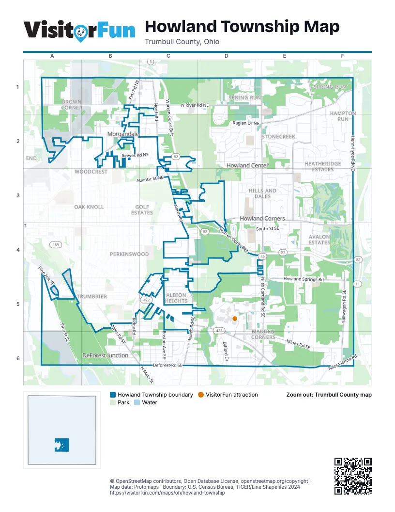
Street index of Howland Township
Each street on the sheet and the grid squares it crosses.
- Warren Outer BeltC1, C2, C3, C4, D4, E4
- East Market StreetD3, E3, C4, D4, E4, F4
- Youngstown Warren RoadC5, D5, D6, E6
- Youngstown Road SoutheastC5
- Niles Cortland Road NortheastE1, E2, E3
- Niles Cortland Road SoutheastE3, E4, E5, E6
- Elm Road NortheastB1, B2
- Niles Road SoutheastB5, B6, C6
- Niles Cortland RoadE4, E6
- North Main StreetC6
- North RoadC1, C2, C3, C4, C5, C6
- North River Road NortheastA1, B1, C1, D1, E1
- Mines Road SoutheastD6, E6, F6
- King Graves Road NortheastE1, F1, E2
- Howland Wilson Road NortheastE2, E3
- Stillwagon Road SoutheastF4, F5, F6
- Deforest Road SoutheastB6, C6
- Howland Springs RoadE5, F5
- Larchmont Avenue NortheastA1, A2
- Howland Wilson RoadE1, E2
- Howland Wilson Road SoutheastE3, E4, E5
- Ridge RoadB5, B6
- Squires Lane NortheastE3
- Kenyon Drive SoutheastD5, E5
- Pine Avenue SoutheastA5
- North Road SoutheastC5, C6
- Niles Vienna RoadF6
- Genesee Avenue NortheastB2
- Blair Drive NortheastB1, C1
- Shaker Boulevard SoutheastD5, D6
- Burton Street SoutheastA5
- Henn Hyde Road NortheastF1, F2, F3, F4
- Eastwood Mall BoulevardD5, E5
- Pine Street SoutheastA5, A6, B6
- Celestial Drive NortheastF1, F2
- Raglan Drive NortheastD2, E2
- Cain Drive NortheastF2, E3, F3
- Anderson Avenue NortheastD2, E2
- Avalon Drive SoutheastE4, F4
- Castle Rock Drive NortheastD2
- Brittany Oaks Trail NortheastF1, F2
- Bay Hill Drive NortheastF3
- Overland Avenue NortheastA2, B2
- Reeves Road NortheastB2, C2
- Hidden Lakes Drive NortheastE1
- Forest Springs Drive SoutheastE5
- Crestview Avenue SoutheastB6, C6
- Briarbrook Drive NortheastE2, F2
- Orchard Street SoutheastB5, C5
- North Aspen CourtD1, D2
- Dawson Drive SoutheastD5, E5
- Hunt Club TrailF2
- Laurelwood Drive SoutheastD3, D4, E4
- Wilson Avenue NortheastB1, B2
- Brookwood Drive NortheastD2, E2
- Valacamp Avenue SoutheastB6, C6
- Fairview Street SoutheastB5, C5
- East Pointe Drive SoutheastE5, E6
- Great East Plaza SoutheastD5, D6
- SanctuaryD1
- Rosegarden Drive NortheastD3
- Atlantic Street NortheastC3
- Clifton Avenue NortheastD3
- Difford DriveD6
- Seasons BoulevardD1, E1
- Kimblewick Lane NortheastE3
- Boston Avenue SoutheastC5, C6
- South Street SoutheastD4, E4
- Sutton Place NortheastD2
- Sandpiper Southeast TrailD3, D4
- Shadowood Lane SoutheastE4
- Moreland Road SoutheastD6, E6
- Venice Heights Drive NortheastD2, E2
- Altura Drive NortheastE2, F2
- Draper Street SoutheastC5
- Woodbine Avenue SoutheastB6, C6
- Carriage Hill Drive NortheastE2
- Allenwood Drive SoutheastC5
- Weir Road NortheastB2
- Hunter Trail SoutheastE4
- Valacamp Avenue SouthwestB6, C6
- Gypsy LaneD6
- Silver Fox Lane NortheastE1, E2
- Tidewater Street NortheastB1
- Shepherds Way NortheastD1, D2
- Westover Drive SoutheastC4, C5
- Curtis Avenue SoutheastC6
- Bronze Road NortheastA2
- Ridgelawn Avenue SoutheastC6
- Pheonix Road NortheastB1, A2, B2
- Hoffman Circle NortheastC2
- Aleesa Drive SoutheastC5
- Gretchen Drive NortheastB2, C2
- Westchester Drive SoutheastF4
- Glen Oaks Drive NortheastD2
- Sherwood Drive NortheastE2, F2
- Squirrel Hill Drive NortheastE3
- Darlington Road NortheastE3
- Old Forge Road SoutheastD6
- Springbrook Drive NortheastD1
- Whispering MeadowsC2
- Fairhill Drive NortheastD3, E3
- Stonecreek Lane NortheastE2
- Basswood Avenue NortheastA1
- Bayberry Drive NortheastE2
- Beechwood Avenue NortheastA1
- Deer Creek Lane NortheastE3
- Northwood Drive SoutheastC4
- Shaffer Drive NortheastD3
- Muirfield DriveE4, F4
- Dietz Road NortheastA2
- Thomas Road SoutheastA4, A5
- High Street NortheastD3, E3
- Mill Creek Road SoutheastD6
- Bellwood Drive SoutheastC5
- Ravenwood Drive SoutheastC6
- Pheasant Run Road SoutheastE3, E4
- Castillion Drive NortheastD2
- Devon Street SoutheastC4
- Patchen Avenue SoutheastC5
- Pegotty Drive NortheastD2
- Bruce Drive SoutheastC4
- Adrian Drive SoutheastC5
- North Gulch LaneE1
- Stetson Drive NortheastE2
- Hightree Avenue SoutheastC6
- Evergreen Avenue SoutheastC6
- Spring Run Road NortheastF1
- Commonwealth Avenue NortheastB1, A2
- Elmwood Avenue NortheastA1
- Southwood Drive SoutheastC4
- Meadow Lane NortheastC2
- Bolin Avenue SoutheastB6
- Fairlawn Hts Drive SoutheastC5
- Hilda Drive SoutheastC5
- Hawks LandingF2
- Harvey Avenue SoutheastB6
- South LInden CourtD1
- Wheelock Drive NortheastE3
- Valley Circle NortheastD1, D2
- Morningside RoadC6, D6
- Deer TrailF6
- Palmer CircleE3
- Warwick Road SoutheastE5
- Willow Drive NortheastD3
- Athens Drive SoutheastB6
- Springwood Trace SoutheastE5
- Allyson Drive SoutheastC6
- Overlook Avenue SoutheastC6
- Westwind Drive NortheastD3, E3
- Redwood Avenue NortheastB1
- Oak Forest DriveF6
- Shady Lane NortheastE3
- Quarry Lane NortheastC3
- Old Orchard Drive SoutheastE5
- Micawber Road NortheastD2
- Howland Terrace BoulevardE5
- Phoenix PlaceE6
- Willow Street SoutheastD4, E4
- Jeanette Drive SoutheastC5
- Highlawn Avenue SoutheastC6
- Flory Avenue SoutheastC6
- Potomac AvenueC6, D6
- Elizabeth Avenue SoutheastB6
- Northgate Drive NortheastE3
- Racoon Drive NortheastD2
- Park DriveD5, D6
- Chalfonte Drive NortheastE3
- Spring RidgeF1
- Birchwood Avenue NortheastB1
- East DriveD6
- Amber DriveE5, E6
- Nutley Avenue NortheastB1
- Woodhill Drive NortheastE2, F2
- Cherry Hill Drive NortheastD2
- Singing Hills Drive NortheastE3
- Robert Lane NortheastC2
- Donora Avenue NortheastB2
- Fuller Avenue NortheastE3
- Frederick StreetD6
- Trumbull AvenueD6
- Paulo Northeast DriveC3
- Sunnybrook Drive SoutheastC4, D4
- Roseway Avenue SouthwestC5
- White Oak Drive NortheastE2
- Mistletoe Road SoutheastC6, D6
- Surrey Road SoutheastC5
- Doral Drive SoutheastE4, F4
- Ewalt Avenue NortheastB2
- Heatherwood Drive SoutheastD4
- Sleepy Hollow Drive NortheastE3
- Muir Woods DriveE1, F1
- Cranbrook Avenue NortheastD2
- Longview Drive NortheastD3, E3
- Rosewood Drive NortheastD2
- Black Oak Drive NortheastE2
- Echo Lake Road NortheastE3
- Hidden Hills DriveE5
- Howland Springs Boulevard SoutheastE4, E5
- Johnny Cake Road SoutheastD6, E6
- Timberlane Street NortheastD3
- Griswold Street NortheastA2
- Michael Lane SoutheastC5
- Portal Drive NortheastE2
- Rolling MeadowsE2
- Thorn Drive NortheastE3
- Demura Drive SoutheastC6
- Huntley Drive SoutheastE4
- Lakeview Road SoutheastC6, D6
- Pineview Drive NortheastD2
- Hillview Drive NortheastE2
- Sunview Drive NortheastE2
- Aspinwall Avenue NortheastB1
- Eastwind Drive NortheastD3, E3
- Fonderlac DriveF4
- Brandywine Drive SoutheastD6, E6
- Bradford Lane NortheastE2, F2
- Forest Hill Drive NortheastE3
- Red Rock RunD1
- Old Farm Trail NortheastE3
- Fox Hound RunF2
- Nicklaus DriveE3
- Darlington Road SoutheastE3, E4
- Schenley Avenue NortheastB2
- Bittersweet Drive NortheastE2
- Hiram Place SoutheastD5, E5
- Trentwood Drive SoutheastC6
- Hunters HollowE4
- Thornwood Avenue NortheastA1, B1
- Broadway WayB6
- Duffus Road NortheastE2
- Falcon TractF2
- Valley BoulevardD6
- Breezewood Drive NortheastF2, F3
- Englewood Street NortheastD3, E3
- Kroen Street SoutheastC5
- Masters Collection NortheastF3
- Red Oak Drive NortheastE2
- Old Wagon Lane NortheastE3
- Barder Avenue SoutheastB6
- Supreme Street NortheastA1
- Lafayette Street NortheastA1
- Pinehurst DriveE4, F4
- Pleasant Valley Drive NortheastC2, C3
- Victoria TerraceC4, D4
- Trefeathen Drive NortheastD2
- InverraryE4
- Forest GroveB2
- Stone Ridge Drive SoutheastE4
- North Linden CourtD1
- Hickory Northeast CourtC1
- Liberty Street SoutheastC6
- Den Jean Drive NortheastB2
- Brucewood Drive SoutheastC4
- Greenleaf Avenue NortheastE3
- Park LaneD5, E5
- Burning Oaks Road NortheastE3
- Brewster Drive SoutheastD3, D4
- Forest Pointe Drive SoutheastE5
- Kensington Lane NortheastE2
- Firestone Drive SoutheastE4, F4
- Palette Drive NortheastF2, F3
- East Heights Street SoutheastC4
- Morris Place SoutheastD6
- Stonybrook Drive SoutheastC4
- River Glen RoadD1
- Ashwood Avenue NortheastA1, B1
- Cardiff Lane SoutheastE4
- Welcker Drive NortheastC3
- Harvard Drive SoutheastC5
- Windsor TraceF2
- Mayflower Road SoutheastE3, E4
- Woodland Avenue NortheastD3, E3
- Knickerbocker Drive NortheastD2
- Black Duck CourtD1
- Independent DriveD1
- Asbury LaneD6
- Republic Avenue SoutheastB6
- Brentwood Drive NortheastD3
- Oakwood Drive SoutheastE5
- Eastgate NortheastE3
- Pintail Drive SoutheastE4
- Orchard ExtendedC5
- Westgate Drive NortheastE3
- Dillon SoutheastE4, E5
- Black Oak DriveE6
- Center Avenue SoutheastB5
- Wimber Avenue NortheastB2
- Kettering Street SoutheastD4, E4
- Kingston CourtF3
- Southwind Drive NortheastD3
- Fairgreen Drive NortheastB2
- Kenmore Avenue NortheastB2
- Wendell Place SoutheastD6
- Kimberly Drive NortheastC3
- Oaklawn Avenue SoutheastC6
- Broadway Avenue SoutheastC4
- Virginia Avenue SoutheastB6
- Yale Street NortheastB2
- Oak Tree Lane SoutheastE4
Things to do on the Howland Township map
Places on the map
- 7 17 Credit Union
- Advance Auto Parts
- Advanced Dermatology Warren
- AimPoint Airsoft
- ALDI
- American Eagle Outfitters
- Amish Kitchen
- Andrew's
- Applebee's
- At Home
- Avalon Lakes Golf Course
- Bass Pro Shop - Boat Storage
- Bass Pro Shops
- Bath & Body Works
- Believer's Church
- Believer's Church Traditional Chapel
- Best Buy
- Bibibop
- BMV Driver Testing Course
- Bob Evans
- Bolindale
- Bolindale Park
- Books-A-Million
- Boulevard Centre
- Eastwood Field
- Eastwood Mall
- Great East Plaza
- Griffin/Sloas Airport
- H.C. Mines Elementary School
- Howland Center
- Howland Commons
- Howland Glen Elementary School
- Howland Park Loop
- Howland Township Park
- Howland Township Preserve
- McKinley Centre
- North Commons
- Old Avalon Golf Course
- The Village Center
Next to Howland Township
- Atlantic Heights
- Bellevue
- Belvedere Park
- Buckeye Greens
- Colonial Village
- DeForest
- Eastgate
- Edgewood Park
- Elmwood
- Fairway Estates
- Garden District
- Garfield Heights map
- Golf Estates
- Iddings Park
- Oak Knoll
- Perkinswood
- Reeves Heights
- Trumbrier
- Trumbull Homes
- Warren Commercial Historic District
- Woodcrest
- Woodlawn
© OpenStreetMap contributors, Open Database License, openstreetmap.org/copyright · Map data: Protomaps · Boundary: U.S. Census Bureau, TIGER/Line Shapefiles 2024















