

Ohio map
Trumbull County map
About 200,300 people live here (Census Bureau, 2024 estimate). The sheet's index lists 300 streets; Ridge Road, Youngstown Kingsville Road and State Route 534 cross the most grid squares. Things to do inside the boundary: Eastwood Mall and Trumbull County, OH.
Open the map (PDF, US Letter)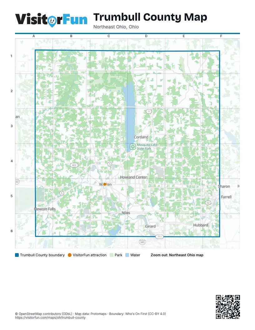
Maps inside Trumbull County
6 maps inside, from the street map of Trumbull County down.
Street index of Trumbull County
Each street on the sheet and the grid squares it crosses.
- Ohio TurnpikeA5, B5, B6
- Warren Outer BeltB4, C4, B5, C5, D5
- Robert E. Hagan Memorial HighwayD6
- Ridge RoadD1, D2, D3, D4, A5, C5, D5
- Kinsman Road NortheastC1, D1, E1, E2
- Youngstown Conneaut RoadE2, E3, E4, E5
- US Route 422 NorthwestA3, A4, B4
- Warren-Sharon RoadD5, E5, F5
- Kinsman Road NorthwestB1, C1
- Parkman Road NorthwestB4, C4, C5
- East Market StreetC5, D5
- West Liberty StreetA5, D6, E6
- West Market StreetB5, C5
- Youngstown Warren RoadC5, D5, D6
- Williamsfield Kinsman RoadE1, E2
- North Main StreetC5, E6
- State Route 7E1
- Brookfield RoadE5
- Warren Burton RoadA3, B4
- Kinsman RoadA1, B1, F1
- Youngstown Hubbard RoadE6
- Youngstown Road SoutheastC5
- South Street SoutheastC5, D5
- Kinsman Nickerson RoadE2, F2
- South State StreetD6
- Hubbard RoadE5, E6
- North State StreetD6
- US Route 422 NWA3, A4
- Main StreetE1, E2, C5
- South Street SouthwestB5, C5
- South Irvine AvenueF5
- State StreetD6
- US 422A3
- Youngstown Kingsville RoadD1, D2, D3, E3, D4, E4, D5
- Wilson Sharpsville RoadC4, D4, E4
- State Route 534B1, B3, A4, B4, A5, A6, B6
- Wood Curtis RoadB1, B2, B3
- Greenville Road NortheastC2, D2, E2, E3
- Salt Springs RoadB6, C6, D6
- Painesville Warren State RoadA3, B3, B4
- Greenville Road NorthwestA2, B2, C2
- Mahoning Avenue NorthwestC3, C4, C5
- Main Avenue SouthwestC5, C6
- Dennison Ashtabula RoadD1, D2
- Tod Avenue SouthwestC5, C6
- Hallock Young Road SouthwestB6, C6
- Belmont AvenueD5, D6
- North State Line RoadF1, F2, F3, F4, F5
- Ellsworth-Bailey Road SouthwestB5, B6
- Niles Cortland Road NortheastD4, D5
- Warren RoadD2, D3, A5
- East Liberty StreetA5, D6, E6, F6
- South Main StreetC5, C6, E6
- Tibbetts Wick RoadD5, E5
- Tod Avenue NorthwestB4, C4, C5
- Oak Hill DriveB3, B4
- Churchill Hubbard RoadD6, E6
- Elm Road NortheastC4, C5
- State Route 5E1, F1
- Hallock Young RoadA6, B6
- Elm RoadC4, D4
- Warren Meadville RoadD3, C4, D4
- Niles Road SoutheastC5
- State Route 305E4, F4
- Center Street WestB4, C4
- Robbins AvenueC5, D5
- Niles Cortland Road SoutheastD5
- Center Street EastC4
- Youngstown Kingsville Road SoutheastD5
- Brockway Sharon RoadF3, F4
- West Main StreetA2, D3, A5, A6
- Niles Cortland RoadD5
- East Main StreetA2, D3, A5
- State Route 88F2, F3
- Milton BoulevardA5, A6
- Chagrin Falls Greenville RoadE2, F2, F3
- West Liberty Street SoutheastE6
- Greenville RoadC2
- Vienna AvenueD5, E6
- Hartford StreetF3
- North High StreetD3
- Summit Street NorthwestC5
- South High StreetD3
- North Mecca StreetD3
- South Mecca StreetD3
- West Broad StreetA5
- East Broad StreetA5, B5
- East Gypsy LaneD6
- Tamarack DriveF4, E5, F5
- Mecca StreetD3, D4
- North Pricetown RoadA6, B6
- State Line RoadF3
- South Maple StreetB1
- Coitsville-Hubbard RoadE6
- County Line Turnpike RoadA3, B3
- Miller AvenueA5
- North Bailey RoadB6
- Elm Road SoutheastC5
- Mahoning AvenueC4
- Hoagland Blackstub RoadC1, C2, C3, C4
- North Park AvenueC1, C2, C3, C4, C5
- Warner RoadE2, E3, E4
- Cadwallader-Sonk RoadD4, E4
- King-Graves RoadD4, E4
- County Line RoadF1, A3, B3, A6, E6, F6
- Donley RoadA1, B1
- Everett Hull RoadD3, E3
- Niles Vienna RoadD5
- North RoadC4, C5
- Chestnut Ridge RoadE5, F5
- Warner Road SoutheastE5, E6
- Highland AvenueC5, C6
- West Mahoning-Trumbull County Line RoadA6, B6
- North Girdle RoadA1, A2
- Stewart Sharon RoadE5, F5
- Carson - Salt Springs RoadB6, C6
- South Canal StreetA5, A6
- North River Road NortheastC4, D4
- Palmyra RoadB5, B6
- Kinsman Pymatuning RoadE1, F1
- Lyntz RoadB6, C6
- South State Line RoadF5, F6
- Five Points Hartford RoadE4
- Ohltown McDonald RoadC6, D6
- Trumbull AvenueC5, D5, D6, E6
- North Leavitt Road NorthwestB4
- North River Road NorthwestB4, C4
- Hubbard Masury RoadF5, E6, F6
- Warren Ravenna Road SouthwestA5, B5
- Bedford Road SoutheastF5
- Palmyra Road SouthwestB5, C5
- Parkman Mesopotamia RoadA1, A2
- Bundysburg RoadA1, A2
- Warner Road NortheastE4, E5
- Pothour Wheeler Road SoutheastF6
- Highland Avenue SouthwestC5
- Gypsy LaneD5, D6, E6
- Larchmont Avenue NortheastC4, C5
- Brunstetter RoadC5
- King Graves Road NortheastD4
- Lewis Seifert RoadE6
- Johnson Plank RoadC4
- Howland Wilson RoadD4
- West Park AvenueC5, E6
- Champion Avenue EastC4
- Scoville North RoadD5
- Ohio AvenueC5, D6, E6
- Depot StreetB4, B5, C6, D6
- Mahoning-Trumbull County Line RoadB6
- Burnett StreetB5, C6, D6
- Mines Road SoutheastD5
- Warren AvenueC5, D5, D6
- Logan WayE6
- Central Parkway Avenue SoutheastC5
- Deforest Road SoutheastC5
- Howland Wilson Road NortheastD4, D5
- Tibbetts Corners Wick RoadE5
- Stillwagon Road SoutheastD5
- Woodland Street NortheastC5
- Logangate RoadE6
- Loganway Wick AvenueE5, E6
- Elm StreetE2, A5, B5, E5, F5, C6, E6
- Colonial DriveD6, E6
- Howland Springs RoadD5
- Pine Avenue SoutheastC5
- Fifth AvenueE6
- Standard AvenueF5
- Ravenna RoadA5, A6
- Genesee Avenue NortheastC4, C5
- High Street NortheastC5, D5
- Burton Street SoutheastC5
- Broadway StreetF5
- Lintz RoadB6
- Niles Warren River RoadC5
- Sampson RoadE6
- North Fox North RoadF5, F6
- State Road NorthwestB4, C4
- Educational Highway NorthwestC4
- Austintown Warren RoadC6
- Jacobs RoadE6
- Elmwood Drive SoutheastF6
- Braceville Robinson Road NorthwestA5
- Howland Wilson Road SoutheastD5
- Ravine DriveE6
- West County Line RoadC6, D6
- East Park AvenueC5, C6, D6, E6, F6
- Hollywood Street NortheastC4, C5
- Addison AvenueF5
- Champion Avenue WestB4, C4
- West 2nd StreetC6, D6
- North Leavitt RoadB4, B5
- Price Shaffer RoadF5, F6
- McDonald AvenueD6
- Laird Avenue NortheastC5
- Marshall RoadD6
- 1st StreetA2, E4, A5, C5, F6
- Ticknor AvenueA5, B5
- Goldie RoadD6, E6
- Owsley North RoadD6
- Old State RoadA3
- Yerke Young Road SoutheastC6
- High Street NorthwestB4, C4, C5
- Ohltown Girard RoadC6
- Holcomb Newton Falls Road SouthwestA5
- Arlington RoadA5
- Sharon-Bedford RoadF5
- Applegate RoadE6
- North Canal StreetA5
- Newton Falls Bailey Road SouthwestA5, B5
- East County Line RoadD6
- Squires Lane NortheastD4
- Shaffer Road NortheastF5
- Van Wye Street SoutheastC5
- North Road SoutheastC5
- Washington Street NortheastC5
- Laird Avenue SoutheastC5
- South Park AvenueC5, D6
- West Marshall RoadD6
- Logan AvenueC5, D6, E6
- Jacobs Road SoutheastE6
- North Chestnut AvenueC5
- Kenyon Drive SoutheastD5
- West Church StreetA5, C5
- Hubbard Sharon RoadF5
- Loganway AvenueE6
- Chestnut Avenue NortheastC5
- Elmwood DriveF6
- East State Street SoutheastC5, C6
- Washington Street NorthwestC5
- Blair Drive NortheastC4
- Fulton Street SoutheastC5
- Grandview RoadA6
- East Marshall RoadD6
- North Lipkey RoadC6
- Chestnut Avenue SoutheastC5
- North Milton BoulevardA5
- Ohltown RoadC6
- Fulton Street SouthwestC5
- Shaker Boulevard SoutheastD5
- Masury RoadF5
- Pine Avenue NortheastC5
- Holcomb RoadA5
- Lansdowne BoulevardE6
- North Duck Creek RoadB6
- Habarka RoadF5
- Robinson RoadB6
- North Four Mile Run RoadD6
- Stoddard Hayes RoadE1, E2, E3
- Housel Craft RoadB3, C3
- Bushnell Campbell RoadE2, E3, E4
- Sodom Hutchings RoadE2, E3, E4, E5
- York StreetC1, D1, E1
- Gardner Barclay RoadC2, D2, E2
- Bradley Brownlee RoadD3, E3
- Orangeville Kinsman RoadE2, F2, F3
- Wakefield Creek RoadD1, E1
- Phalanx Mills Herner RoadA3, A4
- Peck Leach RoadB2, C2
- Custer Orangeville RoadF3, E4, F4
- Davis Peck RoadD2, E2
- Hoffman Norton RoadB2, B3, B4
- Nelson Mosier RoadA4, B4, B5
- Barclay Messerly RoadB3, B4
- Phillips Rice RoadD2, D3
- G. P. Easterly Road NorthwestA3, B3
- Cory Hunt RoadB2, B3
- Bristol Champion Townline Road NorthwestB3, C3
- Eagle Creek RoadB4
- Hyde Shaffer Road NorthwestB3, C3
- Ward North RoadF1, F2
- Braceville Robinson Road SouthwestB4, A5, B5
- Mahan Denman RoadC2, D2, C3
- Durst Clagg RoadC3, C4
- Penniman RoadC1, C2
- Hewitt Gifford Road SouthwestB5, C5
- North Park Avenue ExtensionC3, C4
- Smith-Stewart RoadD5, E5
- West River RoadA5, A6
- Durst Colebrook RoadC1, C2, D4
- Thompson Clark RoadC2, C3
- Morrell Ray RoadC2, C3
- Newton Tomlinson RoadA5, B5, B6
- Kinsman Ridge RoadE1, E2
- Chaffee Dodgeville RoadC1, C2
- Hyde Oakfield Road NorthwestB2, C2
- Stroups Hickox RoadB2, B3
- Sodom Hutchings Road NortheastE4, E5
- Thompson Sharpsville RoadE4, F4
- Curtis Middlefield RoadA2, A3
- Newton Falls-Bailey RoadB5
- Herner County Line RoadA4, B4
- Kale Adams RoadB5
- Plank RoadB1
- Layer RoadB5
- Collar Price RoadE5
- Ensign RoadA3
- Love Warner RoadD2
- Shafer Road NorthwestC3, C4
- Leiby Osborne RoadB4
- Helsley Fusselman RoadA4, B4
Things to do on the Trumbull County map
Places on the map
- Avalon Lakes Golf Course
- Bazetta Township
- Bloomfield Township
- Bolindale
- Braceville Township
- Bristol Township
- Bronzwood Golf Club
- Brookfield Center
- Brookfield Township
- Champion Heights
- Champion Township
- Churchill
- Coalburg Lake
- Cortland
- Environmental Transfer Systems
- Farmington Township
- Fowler Township
- Girard
- Grand River State Wildlife Area
- Grand River Wildlife Area
- Greene Township
- Gustavus Township
- Hartford Township
- Hilltop
- Howland Center
- Howland Township
- Howland Township Preserve
- Hubbard
- Hubbard Township
- Hugh's Nursery
- Johnston Township
- Kinsman Center
- Kinsman Township
- Lake Girard
- Leavittsburg
- Liberty Township
- Mosquito Creek State Wildlife Area
- Mosquito Lake State Park
- Shenango Wildlife Area
- Sugar Island Preserve
Next to Trumbull County
- Farrell
- Sharon
© OpenStreetMap contributors, Open Database License, openstreetmap.org/copyright · Map data: Protomaps · Boundary: Who's On First (CC-BY 4.0); Quattroshapes (CC BY 2.0)















