

Ohio map
Lawrence Township map
About 13,604 people live here (Census Bureau, 2024 estimate). The sheet's index lists 297 streets; Great Lakes Boulevard Northwest, Erie Avenue Northwest and Manchester Avenue Northwest cross the most grid squares. Things to do inside the boundary: Clay's Resort Jellystone Park, Sluggers & Putters and Sluggers & Putters Amusement Park.
Open the map (PDF, US Letter)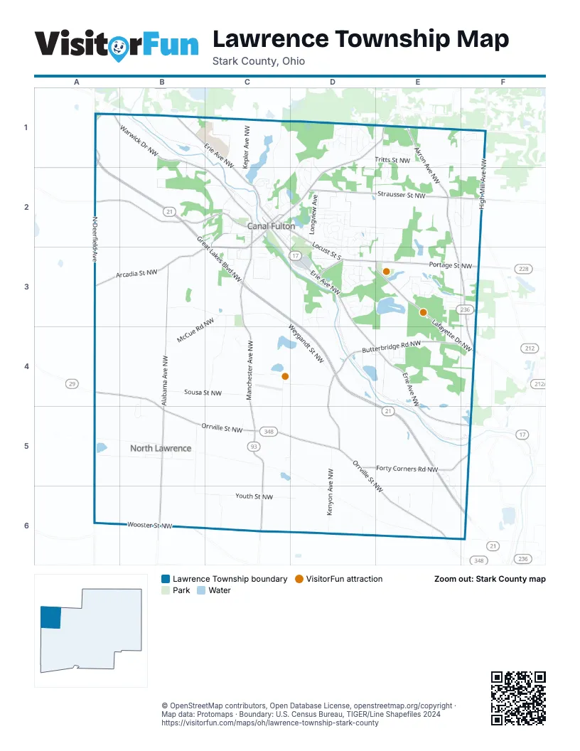
Street index of Lawrence Township
Each street on the sheet and the grid squares it crosses.
- Deerfield Avenue NorthwestA1, A2
- Great Lakes BoulevardA1
- Great Lakes Boulevard NorthwestA1, A2, B2, C3, D3, D4, E5, E6, F6
- Warwick Drive NorthwestA1, B1, B2, C2
- Erie Avenue NorthwestB1, C1, C2, D3, D4, E4, E5, F5
- Indian Hill Circle NorthwestB1
- Shoemaker Avenue NorthwestB1
- Benner RoadC1
- Kepler Avenue NorthwestC1, C2
- Leaver Avenue NorthwestC1, C2
- School Bus LoopC1
- Camelot Avenue NorthwestD1
- Cherryridge Avenue NorthwestD1
- Chestnut CircleD1
- Chestnut Street NorthwestD1
- Denshire Drive NorthwestD1, D2
- Elmfield Avenue NorthwestD1
- Fairpark Avenue NorthwestD1
- Geneva Street NorthwestD1, E1
- Glencoe Street NorthwestD1
- Greenleaf CircleD1
- Greenmeadow Avenue NorthwestD1
- Manchester Avenue NorthwestD1, E1, D2, C3, C4, C5, C6
- Mardel Avenue NorthwestD1
- Meadow View Drive NorthwestD1, D2
- Rock Spring CircleD1
- Shireden AvenueD1, D2
- Skyline Street NorthwestD1
- Spring Grove Avenue NorthwestD1, E1
- Sunset Valley Avenue NorthwestD1
- Thurston StreetD1, D2
- Tritts Street NorthwestD1, E1
- Westspring Circle NorthwestD1
- Akron AvenueE1
- Akron Avenue NorthwestE1, E2, E3, F3, F4
- Babst Avenue NorthwestE1
- Chevelle Avenue NorthwestE1
- Grand Ridge Road NWE1, E2
- Johnston Street NorthwestE1, F1, E2
- Lloyd Street NorthwestE1
- Manchester RoadE1
- Michelle Drive NorthwestE1
- Ridgeland AvenueE1, E2
- Sherri Avenue NorthwestE1
- Timberlink Road NorthwestE1, F1
- Willingham Drive NorthwestE1, F1
- Cliffview Street NorthwestF1
- Edgecliff Street NorthwestF1
- High Mill Avenue NorthwestF1, F2
- Radmoor Street NorthwestF1
- Vandergriff Avenue NorthwestF1
- Marshallville Street NorthwestA2, B2, C2
- North Deerfield AvenueA2, A3
- Alabama CourtC2, C3
- Alaska CourtC2
- Alexis LaneC2
- Alissa LaneC2
- Arcadia Street NorthwestC2, A3, B3, C3
- Arizona CourtC2
- Ash StreetC2
- Baylor StreetC2
- Birch StreetC2
- Blueberry Street NorthwestC2
- Bluffton StreetC2
- Bluffton Street NorthwestC2
- Bradley PlaceC2
- Brown PlaceC2
- Burget CourtC2
- Butler PlaceC2
- Canal Street NorthwestC2
- Canal Street SouthC2, C3, D3
- Case PlaceC2
- Cathedral RoadC2
- Cedar StreetC2
- Cherry Street EastC2, D2
- Cherry Street WestC2, C3
- Cherrywood LaneC2
- Cherton Street NorthwestC2, C3
- Chippewa StreetC2
- Citidal PlaceC2
- Colby PlaceC2
- Colony RoadC2, D2
- Cornell PlaceC2
- Dakota Street NorthwestC2
- Deborah CircleC2, D2
- Drake PlaceC2
- East Market StreetC2
- Elm StreetC2
- Forge StreetC2
- Harvard PlaceC2
- Heritage AvenueC2
- Heritage Avenue NortheastC2
- High Street NortheastC2
- High Street SoutheastC2, D2
- James StreetC2, D2
- Knell Circle NorthwestC2
- Laurelwood Street NorthwestC2
- Locust Street NorthC2
- Locust Street SouthC2, D2, D3, E3
- Loyola PlaceC2
- Maine CourtC2
- Market Street WestC2
- Milan Street NorthC2
- Milan Street SouthC2, C3
- Navada CourtC2
- Norton StreetC2
- Ohio CourtC2
- Orchard Avenue NorthwestC2
- Poplar StreetC2, D2
- River RoadC2, C3
- Stonehill Avenue NorthwestC2
- Streby StreetC2
- Sugar StreetC2
- Tom Jones PlaceC2
- Tuscarawas Street SoutheastC2
- Walnut Street NorthwestC2
- Walnut Street SoutheastC2
- Water StreetC2
- Waterside AvenueC2
- Wooster StreetC2
- Amundsen DriveD2
- Autumn MeadowD2
- Baffin DriveD2
- Barents DriveD2
- Basswood AvenueD2
- Basswood Avenue SoutheastD2
- Bering DriveD2
- Beverly AvenueD2, D3
- Bob Avenue SoutheastD2, D3
- Brittani Circle NorthwestD2
- Bruce StreetD2, D3
- Burlwood AvenueD2
- Cabot DriveD2
- Cartier DriveD2
- Centennial AvenueD2
- Chris CircleD2
- Circle DriveD2
- Colonial BoulevardD2, D3
- Cook DriveD2
- Courtney LaneD2
- Crestwood StreetD2
- Dan AvenueD2, D3
- Ellsworth DriveD2
- Ericsson DriveD2, D3
- Greenwood DriveD2
- Greenwood Drive SoutheastD2
- Hudson DriveD2
- Kenneth CourtD2
- Lakeview DriveD2
- Layden Avenue NorthwestD2
- Livingston DriveD2
- Longview AvenueD2
- Maynard Avenue NorthwestD2
- Parkview Avenue NorthwestD2
- Pauli StreetD2
- Prospect AvenueD2
- Redwing DriveD2
- Redwood AvenueD2
- Reed StreetD2
- Ries Circle NorthwestD2
- Ross DriveD2
- Saint Brendan DriveD2
- Sandlewood Drive NorthwestD2
- Shackleton DriveD2
- Spring MorningD2
- Steiner StreetD2
- Strausser Street NorthwestD2, E2, F2
- Summer Evening DriveD2, E2
- Tamwood DriveD2
- Tell DriveD2
- Trelake DriveD2
- Dellway Street NorthwestE2, F2
- Eastway StreetE2
- Elm Ridge AvenueE2, E3
- Furnace DriveE2
- Mc Taggart Road NorthwestE2
- Stoneacre Road NorthwestE2, F2
- Arthur Avenue NorthwestF2
- Brownwood Avenue NorthwestF2
- Alabama AvenueB3
- Alabama Avenue NorthwestB3, B4, B5, B6
- Hammock Avenue NorthwestB3
- Weygandt Street NorthwestB3, C3, D4
- Cutten Avenue NorthwestC3, C4
- McCue Road NorthwestC3, B4
- Milhaven Avenue NorthwestC3, D3, D4
- Milhaven Street NorthwestC3
- Riverview StreetC3
- Skyview Street NorthwestC3
- Stonewood Street SoutheastC3
- Avalon DriveD3
- Boatman Drive NorthwestD3
- Brookview Avenue SouthD3
- Byrd DriveD3
- Canal Lock Avenue NorthwestD3
- Cartage Avenue NorthwestD3
- Eastover CircleD3
- Echoing Ridge ApartmentD3
- Feeder Run Circle NorthwestD3
- Gateway Drive NorthwestD3
- Gloria CircleD3
- Herbert LaneD3
- Kirkland Street NorthwestD3
- Ledgeview Street NorthwestD3
- Lockage Street NorthwestD3
- Lockland Circle NorthwestD3
- Michael Barkey Avenue NorthwestD3
- Mill Race Street NorthwestD3
- Millfield Road NorthwestD3
- Nist Circle NorthwestD3
- Packets Street NorthwestD3
- Patroon Circle NorthwestD3
- Poleman St CircleD3
- Rimview Avenue NorthwestD3, D4
- Slavin Circle NorthwestD3
- St Helena DriveD3
- St Helena Drive NorthwestD3
- Stover Farm CircleD3
- Stover Farm Drive NorthwestD3
- Tammy CircleD3
- Tollway Circle NorthwestD3
- Towline Drive NorthwestD3
- Towpath Avenue NorthwestD3
- Watercourse Circle NorthwestD3
- Westly Circle NorthwestD3
- Westover Circle NorthwestD3
- Chiltern Road NorthwestE3
- Cuillin Circle NorthwestE3
- Deveron Circle NorthwestE3
- Elmvale Avenue NorthwestE3
- Etheridge BoulevardE3
- Ivyhill Drive NorthwestE3
- Ivyview StreetE3
- Lafayette Drive NorthwestE3, E4, F4
- Mapleview Street NorthwestE3, F3
- Persimmon Street NorthwestE3, F3
- Portage Street NorthwestE3, F3
- Scatell Street NorthwestE3, F3
- Yare Circle NorthwestE3
- Bluedell Circle NorthwestF3
- Coyla Avenue NorthwestF3
- Gardner Street NorthwestF3
- Hann Avenue NorthwestF3
- Idlelawn Avenue NorthwestF3
- Silver Leaf Avenue NorthwestF3
- Skylite Street NorthwestF3
- Orrville Street NorthwestA4, B4, B5, C5, D5, E6
- Griffith Circle NorthwestB4, B5
- Sousa Street NorthwestB4, C4
- Gaddis StreetC4
- Patterson Street NorthwestC4, D4
- Penbrook Avenue NorthwestC4, C5
- Butterbridge Road NorthwestD4, E4, F4, D5
- Caroland Circle NorthwestD4
- High Circle NorthwestD4
- Hycrest Circle NorthwestD4
- Key Circle NorthwestD4
- Banning CircleE4
- Biddeford Street NorthwestE4
- Bonham AvenueE4
- Bonham Avenue NorthwestE4
- Braddock Street NorthwestE4
- Brewton Avenue NorthwestE4
- Bridgeport Avenue NorthwestE4
- Bristol CircleE4
- United Fellowship ParkF4, E5, F5
- Lawmont Street NorthwestA5, B5
- Cenmont Street NorthwestB5
- Churchfield Avenue NorthwestB5
- Churchfield Street NorthwestB5
- Clermont Avenue NorthwestB5, B6
- Easter Avenue NorthwestB5
- Grant Avenue NorthwestB5
- Merry Street NorthwestB5
- Millside Avenue NorthwestB5
- Penford Street NorthwestB5
- Water Street NorthwestB5
- Waterway Street NorthwestB5
- Heck Boulevard NorthwestC5, D5
- Tabellion Avenue NorthwestC5
- Top O Hill Mhp NorthwestC5
- Forty Corners Road NorthwestD5, E5, F5
- Kenyon Avenue NorthwestD5, D6
- Beaumont Avenue NorthwestE5, E6
- Carmela Circle NorthwestE5, E6
- Michael Circle NorthwestE5
- Nicholas Circle NorthwestE5
- Raymond Circle NorthwestE5
- Thomas BoulevardE5
- Thomas Boulevard NorthwestE5, E6, F6
- Wooster Street NorthwestA6, B6
- Youth Street NorthwestB6, C6, D6
- Ben Fulton Avenue NorthwestC6
- Deermont Avenue NorthwestD6
- Highbrook Avenue NorthwestE6
- Karen Avenue NorthwestE6
- Young Avenue NorthwestE6
Things to do on the Lawrence Township map
Places on the map
- AutoZone
- Batting Cages
- BellStores
- Canal Fulton
- Canal Fulton Christian Fellowship
- Canal Fulton Police Department
- Canal Fulton Post Office
- Canal Fulton Provisions
- Canal Fulton Public Library
- Canal Grille
- Cherry Blossom Banquet Hall
- Church of the Nazarene
- Circle K
- Clay's Resort Jellystone Park
- Clays Park Lake
- Clays RV Airport
- Coronado Lake
- Discovery Park
- Dollar General
- Dollar Tree
- Fulton Animal Hospital
- Fulton East Center
- Fulton Hardware
- Giant Eagle
- Heritage Square Pharmacy
- Lake Lucern
- Lawrence Township Fire Department
- Lawrence Township Park
- Lock 4 Park
- Mulhauser Park
- NAPA Auto Parts
- Newman Cemetery
- Newman Creek Cemetery
- North Lawrence
- North Lawrence Post Office
- Ohnoname 10 Reservoir
- Portage Plaza
- Saint Phillips Cemetery
- St Helena Park
- Union Cemetery
© OpenStreetMap contributors, Open Database License, openstreetmap.org/copyright · Map data: Protomaps · Boundary: U.S. Census Bureau, TIGER/Line Shapefiles 2024















