

Ohio map
Liberty Township map
About 21,325 people live here (Census Bureau, 2024 estimate). The sheet's index lists 300 streets; Belmont Avenue, Tibbetts Wick Road and Churchill Hubbard Road cross the most grid squares. Also on it: Churchill, Girard and Lake Girard.
Open the map (PDF, US Letter)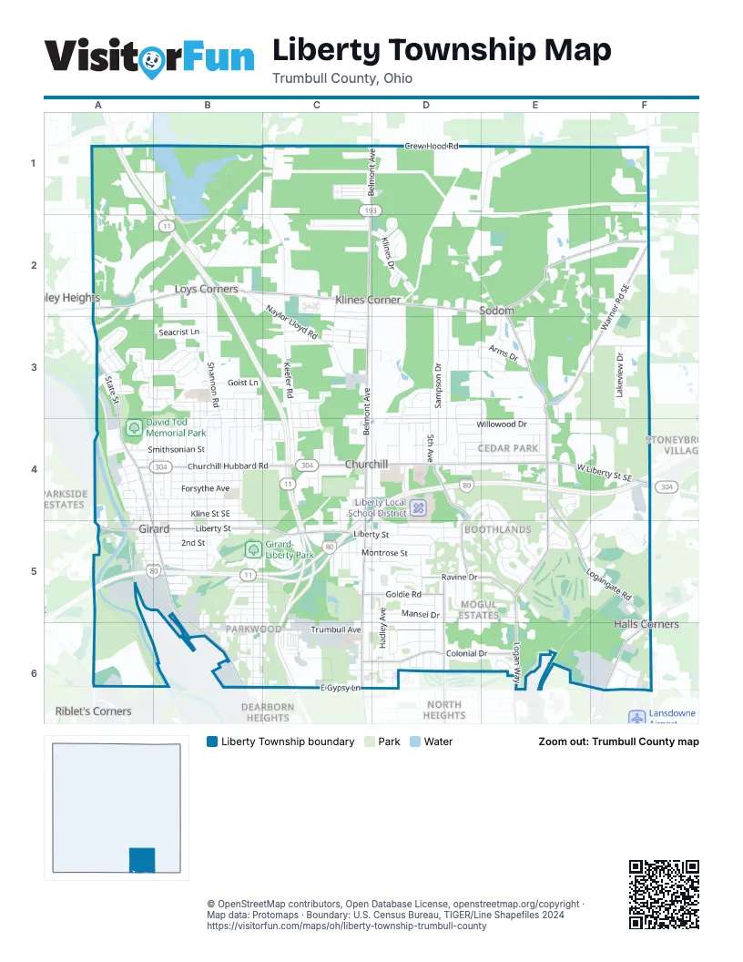
Street index of Liberty Township
Each street on the sheet and the grid squares it crosses.
- Robert E. Hagan Memorial HighwayC5, C6
- South State StreetB5, B6
- North State StreetA3, A4, B5
- Youngstown Hubbard RoadF6
- Youngstown Warren RoadA3
- State StreetC3, B6
- Hubbard RoadF6
- Belmont AvenueC1, D1, C2, C3, C4, C5, C6
- Tibbetts Wick RoadA2, B2, C2, D2, E2
- Churchill Hubbard RoadA4, B4, C4, D4, E4
- East Liberty StreetB5, C5
- West Liberty Street SoutheastE4, F4
- West Liberty StreetF4, A5, B5
- East Gypsy LaneC6
- Salt Springs RoadA6
- Warner Road SoutheastF1, F2, E3, F3
- Trumbull AvenueB6, C6, D6
- Logan WayE4, E5, E6
- Tibbetts Corners Wick RoadE2, F2
- Logangate RoadE4, E5, F5, F6
- Loganway Wick AvenueE2, E3, E4
- Colonial DriveC6, D6, E6
- Sampson RoadD4, D5
- Ravine DriveD5, E5
- Fifth AvenueD5, D6
- Goldie RoadC5, D5
- Loganway AvenueE4
- Applegate RoadF6
- Gypsy LaneC6, E6
- Logan AvenueE6
- Sodom Hutchings RoadE1, D2, E2, E3
- Shannon RoadB2, B3, B4
- Keefer RoadC2, C3, C4
- Sampson DriveD2, D3, D4
- Mansel DriveC5, D5, E5
- Naylor Lloyd RoadB2, C2, C3
- Pleasant Valley RoadC1, C2
- Crew Hood RoadD1, E1
- Logan Arms DriveD3, D4
- Mosier RoadB5, C5
- North Ward AvenueB3, B4, B5
- Park AvenueC3, A4, B4
- North Highland AvenueB3, B4, B5
- Park DriveB5, C5, C6
- Anderson Morris RoadA1, A2, B2
- Klines DriveC2, D2
- Redfern DriveE4, E5
- East Kline Street SoutheastA4, B4
- East Prospect Street SoutheastA4, B4
- 5th AvenueD3, D4, D5
- Hazel StreetA4, B4
- East Broadway AvenueA4, B4
- Willowood DriveD4, E4
- Washington Avenue SoutheastB3, B4
- North AvenueA4, B4
- Oriel Rogers RoadB2, C2
- Townsend AvenueD4, E4
- Smithsonian StreetA4, B4
- Shady RoadD4, D5
- Squaw Creek DriveA3
- Virginia TrailE5
- Liberty StreetC5, D5
- Lawrence Avenue SoutheastB4
- Country Club DriveE5
- East Montrose StreetC5, D5
- Shannon Cross Wartman RoadB2
- East Wilson AvenueB5
- Forsythe AvenueB4
- Hadley AvenueD5, D6
- Woodlawn Avenue SoutheastB3, B4
- Beechwood AvenueB3, B4
- Euclid BoulevardC5, D6
- Overbrook AvenueD4, E4
- Goist LaneB3, C3
- Lakeview DriveF3
- Catherine StreetC5, D5
- Appaloosa LaneE2
- Arabian DriveE2, F2
- Murray Hill DriveD5
- Lucretia DriveC2
- Wellman Avenue SoutheastB4, B5
- North Street Clair AvenueB4, B5
- Powers Avenue SoutheastB4
- Arbor CircleD5
- Dearborn Street SoutheastB6
- South Davis Street SoutheastB6
- Cardinal DriveD5, D6
- Laurel StreetC5, D5
- Michigan BoulevardD3, D4
- Taylor Avenue SoutheastB5, C5
- Gary Avenue SoutheastB3, B4
- Academy DriveD4, E4, E5
- St Andrews DriveD5
- Oak StreetA3
- Seacrist LaneA3, B3
- Mount Everett RoadF3
- Arms DriveD3, E3
- Ohio Avenue SoutheastB5, C5
- Twin Oak DriveE3
- Beverly Hills DriveD3, D4
- East 2nd StreetB5
- Joan Avenue SoutheastB5
- Goleta AvenueD6
- East Howard StreetB5
- Crestwood Boulevard SoutheastE5, F5
- Trails Edge DriveD3, E3, E4
- Edward StreetC2, C3
- Parkwood AvenueD4, D5
- Liberty AvenueC2, C3
- Motor Inn DriveC4, C5
- Homestead RoadF6
- South Saint Clair AvenueB5
- Northlawn DriveD5
- Ventura DriveD4
- Stonnington DriveE5
- Harding AvenueC3
- Crumlin Avenue SoutheastB5
- Wilson AvenueC3
- Yvonne DriveD5
- East Arms DriveE3
- Morris Avenue SoutheastB5
- Fisher DriveE3
- Thomas LaneB2
- North Davis StreetB5, B6
- Smithsonian AvenueD4, E4
- East Main Street SoutheastA5, B5
- Pinecrest RoadC4
- March AvenueD4
- Aurora DriveD3, D4
- Beaver AvenueB3
- Verona Street SoutheastB6
- East DriveD4
- South Lorain Avenue SoutheastB6
- South Highland Avenue SoutheastB5
- Lamplighter DriveD3, E3
- Greenbrier DriveE2, E3
- Staunton RoadD5
- Mill StreetA5
- Ohio TrailD5
- North Elruth StreetB4
- Royal Arms DriveD3
- Tanglewood DriveE4
- Plymouth Avenue SoutheastB6, C6
- Lincoln Avenue SoutheastB4
- Mill Run DriveE5
- Dravis Street SoutheastB4
- Tomilu DriveC3
- Navajo TrailA3, B3
- South Market StreetA5
- Richards DriveD6
- Daffodil LaneF1
- Burning Tree LaneF4, E5, F5
- Wildfern DriveE5
- Louis LaneC1
- Rockwood DriveE4
- Norwick DriveD5, E5
- South Elruth AvenueB5
- Belgrade AvenueB6, C6
- Mohican DriveB3
- Monticello DriveE4, E5
- Moccasin TrailB3
- Leopard WayD4, D5
- Lincoln AvenueC3
- Byers AvenueA5
- Potters CircleD2
- Villa PlaceB3, B4
- East Park CircleC5
- Garfield AvenueC2
- Green Acres DriveD6
- Vienna AvenueD4
- Timbercrest StreetD4, E4
- Illinois Avenue SoutheastB5, C5
- Excellence DriveC3, C4
- Stull AvenueB3
- Breeze Knoll DriveD5
- Madison RoadE4
- Krehl Avenue SoutheastB4
- McArthur DriveC4
- Oriole DriveE6
- Denver DriveD5
- Park StreetE4, C6
- Esme DriveC4
- Mohawk DriveB3
- Cheyenne DriveB3
- Tuttle LaneC1
- Iowa Avenue SoutheastB5, C5
- Marla DriveC1
- Townsend Avenue SoutheastA4, B4
- West Montrose StreetC5
- North Stewart Avenue SoutheastB4, B5
- Northgate DriveD6
- Shawnee DriveB3
- Craver AvenueB6, C6
- Red Oak DriveC4
- Atlanta Avenue SoutheastC6
- Marlane DriveC3
- Millicent AvenueE4
- Rose AvenueC3
- Santa Monica DriveD3
- Trumbull CourtC6, D6
- Broadview AvenueB6, C6
- Patricia DriveB3, B4
- Gayla LaneC6
- Northview BoulevardD6
- Childrens DriveD6
- Elmwood AvenueC5
- Summit Avenue SoutheastC5, C6
- Engleton LaneD3
- Amherst Avenue SoutheastB6, C6
- Logan Woods DriveD3, E3
- Fairway DriveE6
- Walker CircleD2
- Hazelwood DriveC5
- Leslie LaneC3, C4
- Roosevelt DriveD6
- Greenwood Avenue SoutheastA3
- Juaniata Avenue SoutheastB6, C6
- Center AvenueA3
- Lois LaneC3, C4
- West Prospect StreetA4
- Ella StreetA4
- Rush Avenue SoutheastA4
- Olive Street SoutheastA4, B4
- Glendale Avenue SoutheastA3
- Jo Ann LaneD4
- Terra Bella DriveC3, D3
- Tod Avenue SoutheastB4
- Marshall RoadA5
- Seneca DriveA3, B3
- West Broadway AvenueA4
- Oakwood DriveC5
- Haviland DriveD5, E5
- James LaneC1
- Scott LaneC1
- High Street SoutheastA4, A5
- Underwood DriveB3
- CherryA4, B4
- North ElruthB4, B5
- North Market StreetA4, A5
- Norwood Avenue SoutheastA3
- South Stewart Avenue SoutheastB5
- Vine StreetC3
- Kingwood LaneD3
- Parkview Drive SoutheastB5
- West 2nd StreetA5, B5
- Maple Avenue SoutheastB5
- South Randolph Avenue SoutheastB6
- Grove StreetE4
- Truman AvenueD4
- West Kline Street SoutheastA4
- North Lorain Avenue SoutheastB5, B6
- Pawnee LaneB3
- Pittsburgh Avenue SoutheastA3
- Everett Road WestF1
- Stambaugh Street SoutheastA4
- Summit StreetE4
- Powder Mill RunE5, F5
- Hickory Trace DriveA3
- Sunny DriveC3
- Shaulis StreetB1, B2
- Hancock Street SoutheastA5, B5
- West Wilson AvenueA5, B5
- Barth DriveD6
- Harry Street SoutheastA4
- Idaho Avenue SoutheastB5, C5
- Emma Street SoutheastB5
- Topperhill DriveE3, E4
- Dunn DriveD2
- Middle RoadD4
- Frederick StreetC6
- Indiana AvenueB5, C5
- Robinwood Boulevard SoutheastC6
- Biscayne AvenueD6
- Orchard AvenueC5
- Belmar DriveD6
- Susan LaneC3, C4
- Holly DriveC4, C5
- Gordon StreetA4
- Sioux TrailA3
- Water StreetA4
- Louis AvenueB5
- Utah Avenue SoutheastC6
- Maplewood AvenueC5
- Klines CoveD2
- Skoplee AvenueB6
- Abbey Street NortheastA5, B5
- Whipoorwill WayE4, E5
- Taylor AvenueC4
- Crandon LaneA4, A5
- West Main Street SoutheastA5
- Commerce AvenueA4
- Merrill RoadF6
- Logan Hill DriveE3
- Summit DriveC6
- Sommerset DriveF5
- Moorelene Drive SoutheastC4
- Furnace LaneA5, B5
- Earl Street SoutheastB5, B6
- Darlington Avenue SoutheastC6
- Golf AvenueC4
Places on the map
- ALDI
- Belmont Confections
- Belmont Park Cemetery
- Belmont Pines Hospital
- Black Horse Tavern
- Bob Evans
- Burger King
- Center Park
- Church Hill Cemetery
- Churchill
- Churchill Commons
- Churchill Park
- Churchill United Methodist Church
- Citizens Bank
- Comfort Inn & Suites
- David Tod Memorial Park
- Days Inn & Suites by Wyndham Youngstown / Girard Ohio
- Denny's
- Dollar General
- Driving Range
- DTLR
- EZ Self Storage
- Farm Pond
- Five Below
- Giant Eagle
- Girard
- Girard Free Public Library
- Girard Liberty Union Cemetery
- Girard Post Office
- Girard-Liberty Park
- Goodwill
- Hampton Inn Youngstown-North
- Jewish Community Center - Logan Campus
- Jib Jab Hot Dog Shoppe
- Lake Girard
- Liberty Local School District
- Little Girard Creek Conservation Park
- Mahoning Country Club
- Tri-County Sports Complex
- Youngstown Country Club
Next to Liberty Township
- Dearborn Heights
- McDonald Heights
- McKinley Heights
- North Heights
- Parkside Estates
- Riblet's Corners
- Stoneybrooke Village
- Tibbetts Corners
© OpenStreetMap contributors, Open Database License, openstreetmap.org/copyright · Map data: Protomaps · Boundary: U.S. Census Bureau, TIGER/Line Shapefiles 2024















