

Ohio map
Marietta map
About 13,039 people live here (Census Bureau, 2024 estimate). The sheet's index lists 300 streets; Greene Street, Lancaster Street and Pike Street cross the most grid squares. Things to do inside the boundary: Marietta-Washington County and Ohio River Museum.
Open the map (PDF, US Letter)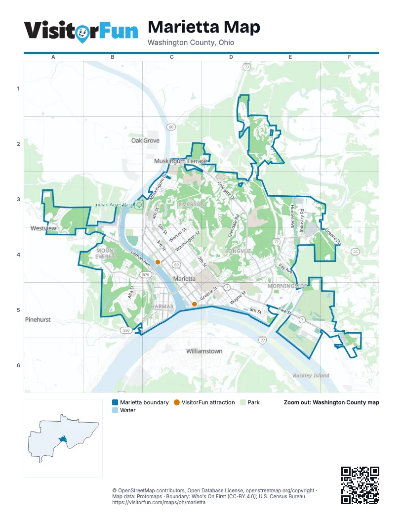
Street index of Marietta
Each street on the sheet and the grid squares it crosses.
- Greene StreetD4, E4, F4, C5, D5
- Pike StreetD5, E5, F5, F6
- 3rd StreetC3, C4, C5, D5
- Muskingum DriveC2, C3
- Fort Harmar DriveC4, B5, C5
- Washington StreetC4
- Acme StreetE4, E5
- Williamstown BridgeD5
- Washington Street BridgeC4
- South 5th StreetD5
- Lancaster StreetA3, A4, B4, C4, C5
- Gilman AvenueB4, C4, C5
- Putnam StreetC4, D4, C5
- Virginia StreetB5, C5
- South 7th StreetD5
- Putnam Street BridgeC5
- Putnam AvenueC5
- Stone StreetC4
- Walnut StreetC4
- West Putnam StreetC5
- Colegate DriveC2, D3, D4, E4
- 4th StreetC3, C4, C5, D5
- Front StreetC3, C4, C5
- 2nd StreetC4, C5
- North 7th StreetC3, C4, D4, D5
- County Road 4B3, B4
- Butler StreetD4, C5, D5
- Franklin StreetC5
- Groves AvenueB4
- Market StreetC5
- C4B3
- Glendale RoadE2, D3, D4
- Cisler DriveC3, D3, C4
- 5th StreetC3, C4, D5
- 6th StreetC3, C4, D4
- County Road 375D2, E2, D3
- Hillcrest DriveD3, D4
- Phillips StreetD4, E5
- Pearl StreetB5, C5
- Hunter AvenueE3, E4
- Warren StreetC3, C4
- 8th StreetC3, C4, D5
- Wooster StreetC4
- Industry RoadE3, E4
- Montgomery StreetC3, C4
- Maple StreetC5
- Aurora StreetD4
- Matthew StreetC3, C4
- Marietta LaneC3, C4
- Highschool LaneC4
- Hadley LaneD4
- Harmar StreetC5
- Wayne StreetD5
- Bellevue StreetC4, C5
- Alta StreetB4, B5
- Grove StreetD4, E4
- West Fay AvenueE4
- East 8th StreetD5, E5
- Coventry RoadB5
- East Spring StreetD4, E4
- Pennsylvania AvenueC3, C4
- Westview AvenueB3
- Edgewood DriveB4, B5
- Timberline DriveD2, E2
- Merryhill StreetD3
- Oakwood AvenueD4, E4
- Davis AvenueC3
- Sunset DriveC3
- Gross StreetD4
- Cisler LaneD3, D4
- Hart StreetD5
- Rathbone RoadC3
- Sacra Via StreetC4
- Scammel StreetC4
- Flintwood DriveA3
- Meadow LaneD3
- South 6th StreetD5
- Hildreth LaneC3, C4
- 9th StreetC3, C4
- Freshman LoopD4, D5
- Riverview DriveB5
- Ridgewood DriveD3, D4
- Fort StreetC5
- Ellsworth AvenueF5, F6
- Chestnut StreetD4, E4
- Fearing StreetC5
- Brentwood StreetD3
- Grant Edwards DriveD2, E2
- Allen StreetC4
- Ohio StreetC5, D5
- West Montgomery StreetB4, C4
- Linwood AvenueB3, C3
- Cullen RoadC3
- Charles StreetD5
- Vista StreetB5, C5
- Marion StreetC3, C4
- Pioneer LaneC4
- Leland AvenueB4
- Wildwood DriveD3
- Pebble DriveA3
- Colegate Woods DriveC2, D2
- Alderman StreetE4
- Moore AvenueE4
- Jefferson StreetE5
- Warner StreetE4, E5
- Margaret StreetF6
- Wagner RoadE2
- Quarry StreetD4, D5
- Congswell LaneE5
- South 8th StreetD5
- Becker LaneD4
- Mulholland DriveD5
- Academy DriveC3, D3
- Sunset LaneD4
- Frederick StreetE4, E5
- Grandview AvenueD4
- Barber AvenueC5
- Fairview LaneB4
- Victory PlaceB5, C5
- Lee AvenueC3
- Country Meadow DriveD1, E1, D2, E2
- Wyoming RoadB4, B5
- Union StreetC5
- Clark StreetB4
- Ingleside AvenueE4, E5
- County House LaneF5
- Laramie RoadB4
- Van Bergen StreetE4
- High StreetB5, C5
- Saint Marys AvenueC3
- Windy Point DriveD2
- Arch AvenueE3, E4
- South 3rd StreetD5
- Kingman RoadB4
- Ferguson StreetC3
- Church StreetC5, D5
- Wells AvenueE4, E5
- Lafayette PlaceD5
- 10th StreetC3, C4
- East Montgomery StreetC4
- Rathbone TerraceC3
- Kenwood StreetE4
- Douglas AvenueC4, C5
- Holly StreetE4
- Terrace AvenueE4
- Crooked Run LaneF5
- Oak StreetC3
- South 4th StreetD5
- Tupper StreetC4
- Cherry Tree LaneF5
- Sharon StreetB5, C5
- Gibbons PlaceC3, D3
- Foster LaneC4, D4
- Lower Sheldon AvenueE4
- Woodland AvenueE4, E5
- Belle Meadows DriveD2, E2
- Theis AvenueD4
- Dean StreetC3
- Fair AvenueB4, C4
- Clifton StreetD4
- Sherry DriveE2
- West Spring StreetD4
- Woodcrest DriveD3
- Trail 638E4
- Post StreetC5
- Grand AvenueB4
- Lord StreetC5
- Court StreetD5
- Clinton StreetC5
- Manchester DriveB5
- Caro LaneC3
- Cutler StreetC4
- Ward StreetC5
- Barber StreetC5
- Jackson StreetC3
- Janet RoadD3
- Vine StreetD4
- Browns AlleyB5, C5
- Broughton AvenueE4
- Sheldon AvenueE4
- Elm StreetC5
- Miller AvenueE5
- East Fay AvenueE4
- Gregg StreetC2
- Sheridan StreetE5
- Oakview DriveB5
- Elmwood AvenueD5
- Garfield StreetC3
- Chapel AvenueB5
- Cityview AvenueC3
- Euclid PlaceD4
- Dudley AvenueD4
- Gibbons StreetC3, D3
- Wood StreetC4
- Bartlett StreetB4, C4
- Hickory LaneD3
- Jahn StreetC3
- Crestwood CircleD3
- Mulberry StreetC4
- Putnam PlaceD4
- Sassafras TrailE2
- State StreetE4
- North Hart StreetD4, D5
- Hardwood Center DriveD5
- Park StreetC3
- Ephraim Cutler StreetD4
- Orchard StreetD4
- Stonecrest DriveD2
- Fourth StreetC3
- T342D2
- Channel LaneD4
- Meigs StreetD5
- South Durwood Hoas DriveE5
- Poplar LaneD4
- Nelson AvenueB4
- Smith StreetC4, C5
- Riverside LaneC3
- Mill Creek RoadD3
- Crawford StreetC5
- Mission RoadA3
- Walker StreetD4
- Flint StreetB4, C4, B5
- Lincoln CircleB4
- Lookout ParkB4
- Old Brewery LaneC4
- Sunnyhill DriveB4
- West Sacra Via StreetC4
- Adams StreetC3
- Colonial DriveD4
- Pattin StreetE4
- Cheyenne RoadB4, B5
- Dale StreetC2
- Dawes CircleD3
- Dun-Wrentin RoadD3
- Vernon StreetC5
- Saint Clair StreetC4
- Knox StreetC4
- Camp AvenueC4
- Beaver StreetB4
- Pierce StreetD5, E5
- Whites RoadC4
- Emerson AvenueC3
- Summit StreetB4
- Buckeye AvenueD5
- Ellenwood AvenueC4
- Locust LaneE2
- New StreetC5
- Rathbone LaneC3
- Doris AvenueB4
- Grant StreetE5
- Pine AlleyD5
- Marigold LaneD3
- Dye CircleB5
- Short StreetD4
- George StreetC5
- Locust StreetC3
- Gates AvenueB4
- Main StreetE4
- Pershing RoadB4
- Ridge StreetD4
- Eldridge StreetC3
- Circle DriveB5
- Plum StreetD4
- Split Rock DriveB5
- Fulton StreetC3
- Cedar StreetD4
- Betsy Mitchell LaneD4
- Fort SquareC5
- Boat Club LaneC4
- Riley DriveB5
- Creston DriveC3
- Hillside WayD4
- County Road 16F3
- Porter StreetE4
- South 2nd StreetC5
- Ray RoadC3
- Waldo StreetC3
- North StreetC3
- Prospect StreetC5
- Sassafras TraceE2
- Shellmar DriveD3
- West Ohio StreetC5
- Eggser RoadC3
- Ray StreetC3
- West Butler StreetC5
- Hamilton AvenueC3
- Monroe StreetC5
- Tiber WayC5
- Highland AvenueC3
- Julian AvenueC3
- Woodward AvenueC4
- Kuhn DriveE4
- Emerald StreetD4
- Bank StreetD4
- Crestlyn CourtD3
- College StreetD4
- Highwood AvenueC3
- Curtis BoulevardD4
- Pine LaneA4
- Wilson AvenueF6
Things to do on the Marietta map
Places on the map
- Aldi
- American Legion Hall
- Anderson Hancock Planetarium
- Applebee's
- Arby's
- Buckeye Park
- Buckeye Pond
- Don Drumm Stadium
- Don Drumm Track
- Ewing School
- Frontier Shopping Center
- Gunlock Park
- Indian Acres Park
- Jackson Hill Park
- Kris Mar Woods
- Kroger Wetlands
- Lookout Park
- Lowe's
- Marietta City Hall
- Marietta Country Club
- Marietta Harbor
- Marietta High School
- Marietta Memorial Hospital
- Marietta Middle School
- Marietta RV Park
- Mound Cemetery
- Muskingum Park
- Oak Grove Cemetery
- Ohio Riverfront Park
- Our Front Street Free Library
- Phillips Elementary School
- Pioneer Family Golf Center
- Pioneer Family Golf Range
- Pioneer Park
- Sacra Via Park
- Selby General Hospital
- The UPS Store
- Walmart Supercenter
- Washington County Fairgrounds
- Washington Street Marina
Next to Marietta
- Oak Grove
- Pinehurst
- Springdale
- Unionville
- Westview
- Williamstown
© OpenStreetMap contributors, Open Database License, openstreetmap.org/copyright · Map data: Protomaps · Boundary: Who's On First (CC-BY 4.0); U.S. Census Bureau















