

Ohio map
Marion map
About 35,576 people live here (Census Bureau, 2024 estimate). The sheet's index lists 300 streets; Bennett Street, Mount Vernon Avenue and Davids Street cross the most grid squares. Things to do inside the boundary: Harding Tomb.
Open the map (PDF, US Letter)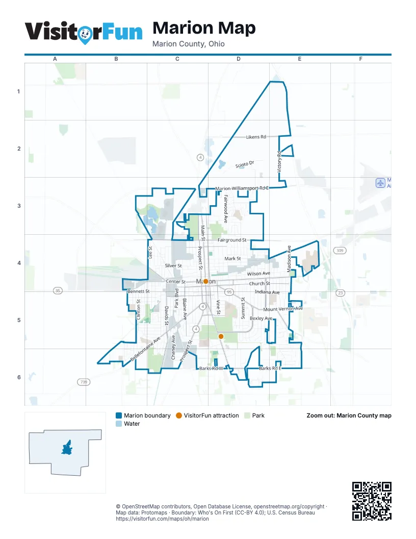
Street index of Marion
Each street on the sheet and the grid squares it crosses.
- Mount Vernon AvenueD4, D5, E5
- Davids StreetC4, C5, C6
- East Center StreetC4, D4, E4
- South Prospect StreetC4, C5, C6
- East Church StreetC4, D4, E4
- West Center StreetB4, C4
- North Main StreetC3, C4
- North State StreetC3, C4, D4
- Delaware AvenueC5, D5, D6
- North Prospect StreetC3, C4
- Blaine AvenueC4, C5
- West Columbia StreetC5
- South Vine StreetD4, D5
- South State StreetD4, D5
- West Church StreetC4
- Kenton AvenueC4
- Patten StreetC4, D4
- Harding Highway EastE4
- East Walnut StreetC5, D5
- Klerx AvenueC4
- Sargent StreetD4
- West Walnut StreetC5
- Delaware StreetD5
- Marion-Marysville RoadC6
- Bellefontaine AvenueC5, B6
- South Main StreetC4, C5
- Richland RoadE5
- Marion-Agosta RoadB4
- East Columbia StreetC5, D5
- Hill StreetC5
- Vernon Heights BoulevardD5
- Marion-Williamsport Road EastC3, D3, E3
- East Fairground StreetC4, D4
- Forest Lawn BoulevardD4, D5
- Barks Road EastD6, E6
- Likens RoadD2, E2
- West Fairground StreetC4
- Barks Road WestC6, D6
- University DriveE4
- Oak StreetC3, C4
- Uncapher AvenueC5, C6
- Wilson AvenueD4, E4
- East Mark StreetC4, D4
- Bennett StreetB4, C4, B5, C5
- Silver StreetC4
- Kellogg ParkwayC3, C4
- Indiana AvenueD5, E5
- Victory RoadE2, E3
- Windsor StreetC4, C5
- Summit StreetD4, D5
- East George StreetC4, D4
- Bexley AvenueD5, E5
- Uhler RoadD5
- Scioto DriveD2
- East Farming StreetC4, D4
- Clinton StreetB4, B5
- Olney AvenueC4, C5
- Leader StreetC4
- Cheney AvenueC5, C6
- Henry StreetC5, C6
- Fairwood AvenueD3
- North Greenwood StreetD4
- Virginia AvenueD5, E5
- Richmond AvenueD3, D4
- Jefferson StreetD4
- Forest Lawn DriveD5
- Brightwood DriveD5
- Pearl StreetC4, C5
- Madison AvenueE4
- Adams StreetD4
- Bermuda DriveD3
- Park BoulevardC4, C5
- Robinson StreetD3, D4
- Woodrow AvenueB5, C5
- Forest StreetD4, D5
- Cambridge AvenueD5
- Ballentine AvenueD4
- Patterson StreetD4
- Hane AvenueD4, D5
- Clover AvenueE4, E5
- Merchant AvenueE4, E5
- Pennsylvania AvenueE4, E5
- Reed AvenueD4, D5
- McKinley Park BoulevardC5, D5
- Girard AvenueC5
- Uhler AvenueD4, D5
- Waterloo StreetC4, C5
- Toulon AvenueD5, E5
- Scioto Village DriveD2, D3
- Merkle AvenueB5, C5
- Congress StreetB5, C5
- Kensington PlaceE4, E5
- South Seffner AvenueD4, D5
- Fies AvenueC4, C5
- Cherry StreetC5
- King AvenueD5
- Park StreetD4
- Leetonia RoadD5
- Barnhart StreetD4
- Mary StreetC4
- South Grand AvenueD4, D5
- Bartram AvenueC4
- Lee StreetC4
- Presidential DriveD5
- Normandy DriveE5
- Loire Valley DriveE5, E6
- Fair Park AvenueD3
- Amboise DriveE5, E6
- Bahama DriveD3
- Fairview StreetC3, D3
- Easy StreetD3
- Spencer StreetE4, E5
- Executive DriveD5, C6
- Quarry StreetC4, D4
- Homer StreetE4, E5
- Likens Chapel RoadD3, D4
- Mound StreetC5
- Franconia AvenueE4
- Harvey DriveD5, D6
- Oak Grove AvenueB5, C5
- South Greenwood StreetD4, D5
- Latourette StreetC4, C5
- Colonial AvenueB5, B6
- Villandry DriveD6, E6
- Wellness DriveD6
- Plantation DriveB6
- North Grand AvenueD4
- Forest Hill DriveD5
- Jackson AvenueB5, C5
- Campbell RoadB6
- Lincoln AvenueD4
- Glad StreetB4, B5
- Sheridan RoadB5, C5
- Chenonceaux DriveE6
- Lake BoulevardD6
- Van Buren StreetD4
- Amherst DriveB5, B6
- Brown AvenueB5, C5
- Thompson StreetC4
- Toledo AvenueC4
- Columbia CourtC5
- Crescent Heights RoadD6
- Nye StreetB4, B5
- Avondale AvenueC4
- Pineridge DriveE6
- South High StreetD4, D5
- Chaumont DriveE6
- East Washington AvenueC5, D5
- Harding RoadD5
- Community DriveD6
- Hampton Woods DriveE6
- Center Park DriveD6
- Bordeaux AvenueE5
- Milburn AvenueC4
- Montego DriveD3
- Superior StreetC5, D5
- Harding Memorial ParkwayD5
- Barks AvenueC5
- Keener AvenueB5, C5
- McKinley Park DriveC5
- Oliver StreetB5
- Darius StreetC5
- Owens StreetC4
- Barbados AvenueD3
- Johnson StreetE4
- Grant StreetD4
- Polk StreetD4
- Tyler StreetD4
- Decatur StreetD4
- Chicago AvenueD4
- Kenmore AvenueE4, E5
- Blois DriveE6
- Daffodil DriveC5
- Chestnut StreetC4
- Buckeye StreetC5
- Duluth AvenueC5
- Universal AvenueC4
- Catherine AvenueC4
- Bryant StreetD3
- Martinique DriveD3
- Old Pond DriveD6
- Scranton AvenueC4
- Orchard StreetC4, C5
- Joseph StreetC4
- Central DriveD3, D4
- Champagne DriveE5
- Chatfield RoadB5, C5
- Hillman-Ford RoadB3
- North Seffner AvenueD4
- Thew AvenueC5
- West Pleasant StreetC5
- Brentwood DriveB5
- Underwood South DriveB5, B6
- Chanteloup DriveE5
- Senate StreetC4
- Foster LaneC5
- Sugar StreetC5
- Gebhardt StreetD4
- Herman StreetC5
- Roberts AvenueD4
- Underwood AvenueB5
- Wood StreetC5
- McKinley PlaceC5
- Littleton StreetD3
- Evans RoadC6
- West Huber StreetC4
- East Pleasant StreetC5, D5
- Whitmore AvenueC5
- Chateau DriveE5
- Gurley AvenueC5, D5
- Edwards StreetC4
- Marseille DriveE5
- Burgundy DriveE5
- Jamaica DriveD3
- Rodney DriveB6
- Heritage LaneB5, B6
- Elm StreetD4, D5
- London StreetC4
- Union StreetC4, C5
- Wilshire DriveE5
- Hamilton StreetD4
- Catalina AvenueC5
- York StreetC4
- Edgewood DriveC5
- Union Park CircleD6
- Bradford StreetD4, D5
- Cass AvenueC4
- Durfee DriveD5
- Smith StreetC6
- Bellevue StreetD4
- Chambord CircleE6
- Wallace StreetC4, D4
- Edison AvenueC5, C6
- Libby LaneD3
- Fairfax RoadD6
- Boone AvenueE4
- Holmes PlaceC4
- Langeais DriveE6
- Bimini DriveD3
- Lilac LaneC5
- Swiss DriveB5
- Grenada DriveD3
- Whitter AvenueB5
- Saint Gallen StreetB5
- Highland AvenueC5
- Cummins AvenueD4, D5
- Ten Eyck CourtC4, D5
- Claridon AvenueE5
- Marion Green ApartmentsD4
- Laura DriveE5
- Cleveland AvenueD5
- Woody Acres DriveE5
- Franklin StreetD5
- Dix AvenueD4
- Osgood StreetC6
- Irey AvenueC5
- Lafayette StreetD5
- Rochelle DriveC5
- Nassau DriveD3
- Carhart StreetD4
- Lakeview BoulevardE6
- Revere DriveB5, B6
- West Lawn DriveC5
- Willow StreetD5
- Hecker StreetC3
- Savannah DriveC5
- Glenwood DriveB5
- Marshall StreetC4
- Dennison AvenueC4
- Marion AvenueC5
- Vanover Square ApartmentsE5
- Cayuga StreetC4
- Miami StreetC5
- Silk StreetC4
- St James StreetD5
- Malo DriveC5
- Niles StreetC4
- Bikini DriveD3
- Grove StreetD4
- Hartford StreetD4
- Garfield StreetD4
- P 200D3
- Essex CourtD4, D5
- Curve StreetB4, C4
- Baker StreetD4
- Elmwood DriveD5
- Ashley DriveB6
- Plymouth StreetB4
- M 258C6
- Tully StreetC4
- Jameson StreetD5
- Belmont StreetD5
- Carner AvenueC5
- White Oaks RoadC6
- Powhatten StreetD5
- Vernon Heights CircleD5
- John StreetD4
- Blake AvenueC4
- Grace DriveD6
- Roma StreetC4
Things to do on the Marion map
Places on the map
- Advance Auto Parts
- America's Mattress
- Apex Church
- Benjamin Harrison Elementary School
- Burger King
- Calvary United Methodist Church
- Central Christian Church
- Chateau Park
- Colonial Acres Elementary School
- DaVita Heart Of Marion Dialysis
- Dollar General
- Dunham's Sports
- Epworth United Methodist Church
- Family Dollar
- Garfield Elementary School
- Garfield Park
- Glenwood Park
- Grant Middle School
- Harding Memorial Park
- Lincoln Park
- Marion Cemetery
- Marion City Hall
- Marion Correctional Institution
- Marion County Fairgrounds
- Marion County Law Library
- Marion General Hospital
- Marion Harding High School
- Marion Medical Campus
- Marion Plaza
- McDaniel GM Superstore
- McKinley Park
- North Central Correctional Camp (Juvenile)
- North Central Correctional Complex
- North Central Correctional Institute
- Quarry Park
- Saint Marys Cemetery
- Sawyer-Ludwig Park
- Taft Elementary School
- Veterans Memorial Park
© OpenStreetMap contributors, Open Database License, openstreetmap.org/copyright · Map data: Protomaps · Boundary: Who's On First (CC-BY 4.0); U.S. Census Bureau















