

Ohio map
Marion County map
About 64,976 people live here (Census Bureau, 2024 estimate). The sheet's index lists 300 streets; Main Street, Harding Highway West and Larue-Prospect Road West cross the most grid squares. Things to do inside the boundary: Harding Tomb, Marion and Terradise Nature Center.
Open the map (PDF, US Letter)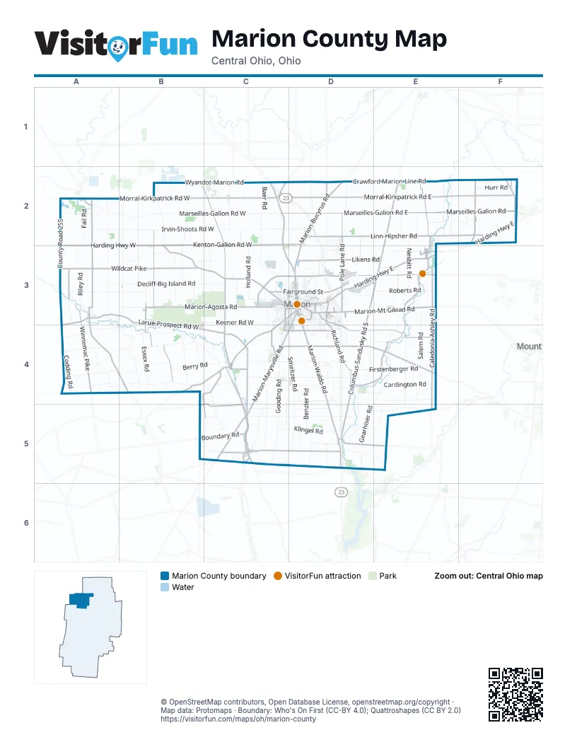
Maps inside Marion County
2 maps inside, from the street map of Marion County down.
City
Town
Street index of Marion County
Each street on the sheet and the grid squares it crosses.
- Harding Highway WestA2, B2, B3, C3
- Harding Highway EastF2, D3, E3
- Marion-Marysville RoadC4, D4, C5
- Marion-Mt Gilead RoadD3, E3
- Marion-Bucyrus RoadD2, D3
- Mount Vernon AvenueD3
- North Main StreetB3, D3, C5
- East Center StreetD3
- Davids StreetC3, C4
- South Prospect StreetD3, D4
- East Church StreetD3
- West Center StreetC3, D3
- North State StreetD3
- Delaware AvenueD3, D4
- North Prospect StreetD3
- Blaine AvenueD3
- West Columbia StreetC3, D3
- South Vine StreetD3
- South State StreetD3
- West Church StreetC3, D3
- Kenton AvenueC3
- Patten StreetD3
- East Walnut StreetA3, D3
- Klerx AvenueD3
- West Walnut StreetA3, D3
- Sargent StreetD3
- Delaware StreetD3
- Columbus-Sandusky Road SouthD3, D4, D5
- Marion-Cardington Road EastD4, E4
- Columbus-Sandusky Road NorthE2, D3, E3
- Larue-Prospect Road WestA3, B3, B4, C4
- LaRue-Prospect Road SouthC4, C5
- Marion-Agosta RoadB3, C3
- Larue-Marseilles RoadA2, A3
- Marion-Waldo RoadD4, D5
- Prospect-Upper Sandusky Road NorthC2, C3
- Prospect-Mt Vernon Road WestC5, D5
- South Caledonia-Ashley RoadE3, E4, E5
- Marion-Upper Sandusky RoadC2, C3, D3
- Richland RoadD3, D4
- Richwood-Larue RoadA3, A4, B4
- Mt Olive-Agosta RoadB3, B4
- Prospect-Upper Sandusky Road SouthC3, C4
- Green Camp-Essex RoadB4, C4
- North Caledonia-Ashley RoadE3
- Marion-Green Camp RoadC4
- Morral-Kirkpatrick RoadC2
- Bucyrus Iberia RoadF2
- Bellefontaine AvenueC3, D3, C4
- Main StreetB3, E3, C4, B5, C5, D5
- Waldo-Delaware RoadD5
- Brush Ridge-Wyandot RoadC2
- South Main StreetD3, C5
- North StreetA3, B3, E3, C5
- West Neff StreetC2
- South High StreetA3, D3
- North High StreetA3, D3
- North Elm StreetE3, C5
- East Water StreetC5
- Prospect-Dublin RoadC5
- East Market StreetA3
- Prospect-Delaware RoadC5
- Water StreetC4, C5
- North Marion StreetD5
- South Marion StreetD5
- Railroad Street EastB3
- Market StreetA3, C5
- West Water StreetC5
- East Columbia StreetD3
- Hill StreetD3
- Agosta-Meeker Road SouthB3
- Essex StreetC4
- Morral-Kirkpatrick Road EastC2, D2, E2, F2
- Linn-Hipsher RoadD2, E2, F2
- Marseilles-Galion Road EastC2, D2, E2, F2
- Wildcat PikeA3, B3
- Morral-Kirkpatrick Road WestA2, B2, C2
- Crawford Marion Line RoadD2, E2, F2
- Kenton-Galion Road WestB2, C2
- Marion-Williamsport Road EastD3, E3
- Whetstone River Road SouthE3, D4, E4
- Wyandot-Marion RoadB2, C2
- Marion-Edison RoadD4, E4
- Pole Lane RoadD2, D3
- Winnemac PikeA3, A4
- Prospect-Upper Sandusky RoadB2, C2, C4, C5
- Likens RoadD3, E3
- Marseilles-Galion RoadE2, F2
- Agosta-Meeker Road NorthB2, B3
- Caledonia-Northern RoadE2, E3
- Martel RoadF2
- Marion-Williamsport Road WestC3, D3
- Centerville-Green Camp RoadB4, C4, C5
- Whetstone River Road NorthE3
- Waldo-Fulton RoadD5, E5
- Boundary RoadB5, C5
- East Fairground StreetD3
- Centerville-Newmans RoadB5, C5
- Wyandot-Marion Road EastC2, D2
- Marion-Galion RoadF2, E3
- Vernon Heights BoulevardD3
- Clark Road NorthA3
- Barks Road EastD4
- Crissinger RoadC4
- Marion-Cardington Road WestC4, D4
- Larue-Mt Victory RoadA3, A4
- West Fairground StreetC3, D3
- Kenton-Galion Road EastC2, D2
- University DriveD3
- Barks Road WestC4, D4
- High StreetB3, E3, C4, C5
- Forest Lawn BoulevardD3
- Blind LaneD2
- County Highway 169D3, D4
- Cardington-Iberia RoadF2
- Owens-Green Camp RoadC4
- RinkerE3
- Marion StreetF2, E3
- Winter StreetC5, D5
- Gast RoadC5
- Blevin's BoulevardD3
- Mill StreetC2, C4
- McMahan BoulevardD3
- Scioto StreetC3, C4
- North Water StreetE3
- Hindman RoadF2
- River RoadC5
- County Highway 90C2
- Marion-Mansfield RoadE3
- Winnemac RoadA4
- Cardington-Denmark-Martel RoadF2
- County Road 61E3
- Marseilles-Galion Road WestA2, B2, C2
- Irvin-Shoots Road WestA2, B2, C2
- Larue-Green Camp RoadA4, B4, C4
- Smeltzer RoadC4, D4, C5, D5
- Newmans-Cardington Road EastD4, E4, D5, E5
- Decliff-Big Island RoadA3, B3, C3
- Gooding RoadC4, C5
- Dry Lane Road NorthA2, A3
- Osbun RoadB2, B3
- Decliff Road NorthB2, B3
- Mt Olive-Green Camp RoadA4, B4
- Holland RoadC2, C3
- Bethlehem Road WestC5, D5
- Emanhiser RoadE2, F2
- Newmans-Cardington Road WestC4, D4, C5
- County Road 255A2, A3
- Hillman-Ford RoadC2, C3
- Larue-Decliff RoadA3, B3
- Salem RoadE3, E4
- Dunbar RoadC4, C5
- Owens Road WestC4, D4
- Claridon-Westfield RoadE4, E5
- Firstenberger RoadD4, E4
- Conley-Thompson RoadB2, B3
- East River RoadE4, E5
- Pleasant Hill RoadB3, C3
- Somerlot Hoffman Road WestC4, D4
- Keener Road WestB3, C3
- Gearhiser RoadD5
- Cardington RoadE4
- Timpson RoadE2
- Centerville-Prospect RoadC4, C5
- Meeker Upper Sandusky RoadB2
- Roberts RoadE3
- Hughes RoadC4, C5
- Prospect-Norton RoadC5, D5
- Klingel RoadC5, D5
- Mautz-Yeager RoadD4
- Lyons RoadE2
- Nesbitt RoadE2, E3
- Windfall RoadA4
- Benzler RoadD4, D5
- Ground Hog PikeB4
- Patton-Riley RoadB4
- Essex RoadB4
- Ground Hog RoadB4
- Berry RoadB4, C4
- Berringer RoadD4, E4
- Prospect-Mt Vernon Road EastD5, E5
- Saint James RoadD4, D5
- Brocklesby RoadE3
- Codding RoadA4
- Hurr RoadF2
- Caledonia Mud PikeE3
- Linwood RoadA4
- Seiter RoadB3
- Caledonia-Bellville RoadF2
- Victory RoadD2, D3
- Fail RoadA2
- Almendinger RoadD5
- Wolfinger RoadD5
- Mason Road WestB3
- Guthery RoadA4, B4
- Riley RoadA3
- Powell RoadD2
- Decliff RoadB2
- Miles RoadA2
- Tobias RoadD2
- Rubins RoadA2
- Baer RoadC2
- Patten PikeD3
- Owens Road EastD4
- Rengert RoadD5, E5
- Allen RoadA4
- Sager RoadA4, B4
- Schweinfurth RoadC4, C5
- Herr RoadC3
- Groll RoadD5, E5
- Arbella RoadA4
- Benzler Lust RoadD4
- Tittlebaugh RoadE4
- Ashley RoadE5
- Lee RoadC2, C3
- New RoadD2, D3
- Irvin-Shoots Road EastC2, D2
- Township Road 255A4
- Campbell RoadC3, C4
- Clark Road SouthA3
- Denzer RoadE5
- Somerlot Hoffman Road EastD4
- Gillette RoadD5
- Deadwood RoadB4
- Mason RoadE2
- Foos RoadE2
- Maple Grove RoadD4
- Espyville Road NorthB3
- Lucas RoadD2
- Bumford RoadB3
- Zeig RoadB4
- Goodnow RoadC2
- Robinson RoadA2, A3
- Larue-Kenton RoadA3
- Bethlehem Road EastD5
- Prospect-Richwood RoadB5, C5
- Lauer RoadD5
- Oak StreetB3, D3
- Green Camp River RoadC4
- East StreetC2, E3
- Fairchild RoadE4
- Espyville Road SouthB3, B4
- White Oaks RoadC4
- Williams RoadE3, E4
- Agosta Northern RoadB3
- Harris RoadA4
- St James RoadD5
- Agosta Larue RoadB3
- Neidhart RoadD4
- Uncapher AvenueC3, C4
- Lawrence RoadE3, E4
- Wilson AvenueD3
- Frame RoadB3
- East Mark StreetD3
- Burris DriveD2, D3
- Kirts RoadC4
- Indiana AvenueD3
- Fairview RoadA4
- Kauffman RoadD4
- East DriveD2, D3
- Fox RoadB5, C5
- Haas RoadD4, E4
- Bennett StreetC3
- South AvenueB3, D3
- Myers RoadD4
- Ruth RoadB4, C4
- Brundage RoadD5
- Silver StreetC3, D3
- Matheny AvenueD3
- Kellogg ParkwayC3
- Likens Chapel RoadD3
- Bell School RoadA4
- Neibauer RoadE4
- Ruehrmund RoadE4
- Claridon-Northern RoadE3
- Fribley RoadC2
- Schmidt RoadB3
- Waldo-Western RoadD5
- Stauffer RoadC2
- Washburn RoadB2
- Brown RoadC2
- Cramer RoadB3
- Ulsh RoadE3
- Cline RoadD5, E5
- Harris DriveD3
- Center StreetC2, F2, E3, D5
- Windsor StreetD3
- Weiss AvenueD2
- Summit StreetD3
- Clinton StreetC3, E3
- Richie RoadB5, C5
- East George StreetD3
- Grandview DriveD2
- Bexley AvenueD3
- Uhler RoadD3
- Fountain StreetC3
- Scioto DriveD3
- Virginia AvenueD3
- Spicer RoadF2
- McNeal RoadF2
Things to do on the Marion County map
Places on the map
- Big Island Township
- Big Island Wildlife Area
- Bowling Green Township
- Caledonia
- Caledonia Cemetery
- Caledonia Nature Preserve
- Claridon Township
- Eastland Towne Center
- Elgin School District
- Foundation Lake
- Grand Prairie Cemetery
- Grand Prairie Township
- Grand Township
- Green Camp
- Green Camp Township
- Hickory Grove Lake Campground
- La Rue
- Lawrence Apple Orchard
- Legacy Crossing
- Lincoln Park
- Marion
- Marion Cemetery
- Marion City Landfill (closed)
- Marion County Fairgrounds
- Marion General Hospital
- Marion Municipal Airport
- Marion Quarry
- Marion Township
- Montgomery Township
- Morral
- New Bloomington
- Pleasant Township
- Prospect
- Prospect Township
- Richland Township
- Salt Rock Township
- Scott Township
- Tully Township
- Waldo
- Waldo Township
Next to Marion County
- Mount Gilead
© OpenStreetMap contributors, Open Database License, openstreetmap.org/copyright · Map data: Protomaps · Boundary: Who's On First (CC-BY 4.0); Quattroshapes (CC BY 2.0)















