

Ohio map
Massillon map
About 32,750 people live here (Census Bureau, 2024 estimate). The sheet's index lists 300 streets; School Bus Loop, Tremont Avenue Southeast and Great Lakes Boulevard Northwest cross the most grid squares. Things to do inside the boundary: Massillon Museum.
Open the map (PDF, US Letter)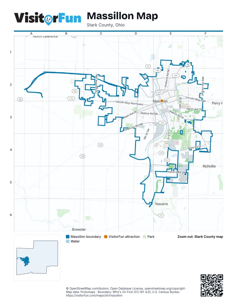
Street index of Massillon
Each street on the sheet and the grid squares it crosses.
- Great Lakes Boulevard NorthwestE2, E3, E4
- Lincoln Way EastE2, F2, E3
- Lincoln Way NorthwestC3, D3
- Wales Road NortheastE1, E2
- Erie Avenue SouthwestE4, E5
- Lincoln Street WestB2, C2, C3
- Lincoln Way WestD3, E3
- Manchester Avenue NorthwestB2
- Wales Avenue NorthwestE1
- Lillian Gish Boulevard SouthwestE3
- Finefrock Road SouthwestD3, E3
- Erie Street SouthE3, E4
- Main Avenue WestD3
- 1st Street NortheastE2
- Walnut Road SouthwestD3, E3
- Richville Drive SouthwestE3, F3, F4
- Walnut Road SoutheastE3
- 3rd Street NorthwestD2, E3
- Hills and Dales Road NortheastE1, F1
- Earl Road NorthwestD2
- Richville Drive SoutheastF4
- Erie StreetE4
- Millersburg Road SouthwestD3
- Lake Avenue NorthwestD2, E2
- Erie Avenue NorthwestE2
- Nave Road SoutheastE4, F4
- 17th Street SouthwestD3, D4
- Tremont Avenue SoutheastE2, F2, D3, E3
- Amherst Road NortheastE1, E2
- 16th Street SoutheastE2, E3
- 3rd Street SoutheastE2, E3
- Tremont Avenue SouthwestD3
- Cherry Road NorthwestD2, E2
- 17th Street NorthwestD2, D3
- 6th Street SouthwestD3, E3
- 8th Street NortheastE2
- Navarre Road SouthwestE5
- Lake Avenue NortheastE2
- State Avenue NortheastE2
- Jackson Avenue NorthwestF2
- Warmington Road SouthwestD4, E4
- Southway Street SoutheastE3, F3
- Hankins Road NortheastE2
- Sterilite Street SoutheastE5
- Erie Street NorthE2, E3
- Alabama Avenue NorthwestA2
- 1st Street SoutheastE2, E3
- Cherry Road NortheastE2
- Stump Avenue SouthwestF4
- Elton Street SouthwestD6
- Wooster Street NorthwestD2
- Hess BoulevardE2, E3
- Nave Street SoutheastF4
- Bailey Street NorthwestF2
- Hankins Road NorthwestF2
- Jackson Avenue SouthwestF3
- Nave Street SouthwestF4
- Carmont Avenue SouthwestD4
- Pigeon Run Avenue SouthwestD4
- 27th Street NortheastF2
- Riverside Avenue NorthwestD2
- 9th Street SouthwestD3, D4
- Millennium Boulevard SoutheastE4, E5
- School Bus LoopB2, E2, D3, E3, F4
- 10th Street NortheastE2
- 11th Street NortheastE2
- Oberlin Road SouthwestD3, E3
- Oak Avenue SoutheastE3, F3
- Harsh Avenue SoutheastE3, F3
- 23rd Street NorthwestD2, D3
- 25th Street NorthwestD2, D3
- North Avenue NortheastE2
- 8th Street SouthwestD3
- Overlook Avenue SouthwestD3, E3
- Rolling Park Drive NorthC2, D2
- 27th Street NorthwestD2, D3
- Kenyon Avenue NorthwestC2
- 3rd Street NortheastE2
- 24th Street NorthwestD2, D3
- Fallen Oak Circle NortheastF2
- 29th Street NorthwestC3
- 2nd Street NortheastE2
- University Drive SoutheastF4
- Augusta Drive SoutheastF3, E4, F4
- 13th Street SoutheastE3
- 4th Street NortheastE2
- Alpha Street NorthwestB2, C2
- 9th Street NortheastE2
- 26th Street NorthwestD3
- Massachusetts Avenue SoutheastE2, F2, F3
- Stoner Avenue NortheastE2, F2
- Indian River Road SoutheastD4, E4
- Cincinnati Drive SouthwestF4
- 14th Street SoutheastE3
- Kenyon Creek Avenue NorthwestC2
- 27th Street SoutheastF2, F3
- Federal Avenue NortheastE2
- Vista Avenue SoutheastE4
- Ledgewood Boulevard NortheastE1, E2
- Parkview Street NortheastE2
- Warmont Avenue SouthwestD5
- Carlene Avenue SouthwestD3
- Johnson Street SoutheastE3
- Massillon Marketplace Drive SoutheastE4
- Connecticut Avenue SoutheastE3, F3
- 32nd Street NorthwestC2, C3
- Valerie Avenue NortheastE2, F2
- Burd Avenue NortheastE1
- Nova Drive SoutheastE4
- Green Avenue SouthwestD3, E3
- 17th Street NortheastE2
- Wellman Avenue SoutheastE2, E3
- South Avenue SoutheastE3
- Forest Avenue SoutheastE3
- 14th Street SouthwestD3
- 1st Street SouthwestE3
- Standish Street NorthwestD2, D3
- Treatment Road SouthwestE4
- Duncan Street SouthwestE3
- Tanglewood Drive NortheastF2
- Duane Avenue NorthwestD3
- Cyprus Drive SoutheastF3, F4
- 15th Street SouthwestD3
- Veterans BoulevardF4
- 7th Street SouthwestD3, E3
- Coventry Road NortheastE1, E2
- 20th Street SoutheastF2, F3
- Commonwealth Avenue NortheastE2
- Paul E Brown Drive SoutheastE3
- Noble Place NorthwestC3
- Vermont Avenue SoutheastE2, F2
- 28th Street NorthwestD2, D3
- Wallace Avenue SoutheastE2
- Huron Road SoutheastE3
- Woodstone Avenue NorthwestB2, C2
- Taggart Avenue NortheastE1
- Russell Boulevard SoutheastE3
- 5th Street SouthwestE3
- Sandy Avenue NortheastE1
- 16th Street NortheastE2
- McKinley Drive SoutheastE4
- 25th Street SoutheastF2, F3
- Lanedale Street NorthwestB2
- Amberwood Circle NortheastF2
- Woodland Avenue SoutheastE3
- Stanton Avenue NorthwestC3, D3
- Stratford Avenue NortheastE2
- Colonial Parkway NortheastE2, F2
- Andrew Avenue NortheastE2
- Sheri Avenue NortheastE1
- 26th Street SoutheastF2, F3
- Marion Avenue SoutheastE3
- Carver Street NorthwestD2, D3
- 12th Street SouthwestD3
- Dexter Road NortheastE2
- Warmington Road SoutheastE4, E5
- Phillips Road NortheastE2
- Rotch Avenue NortheastE2
- Thorne Avenue NortheastE2
- Reservoir Drive NortheastE2
- Venture Circle SoutheastF3, F4
- Terry Avenue NortheastE1
- Gail Avenue NortheastE2
- Pearl Avenue SoutheastE3
- 2nd Street SoutheastE2, E3
- Sheffield Avenue NortheastE2
- Albrecht Street SouthwestD4
- 15th Street NorthwestD2, D3
- Keuper Boulevard NortheastE2
- Glenwood Street SoutheastE3
- Springhaven Circle NortheastE2
- Chauncey Avenue NorthwestD3
- 4th Street SouthwestE3
- Valeside Street NortheastE2
- Beautiful Bit of Eden MhpB2
- Poplar Avenue NorthwestC2, D2
- Championship Circle SoutheastE3, F3
- 11th Street SoutheastE3
- Wetmore Avenue SoutheastE3
- Euclid Street SouthwestD3
- Delivery Road SoutheastE4
- Bison Avenue NorthwestD2
- Mill Ridge Path NortheastF2
- Rhode Island Avenue SoutheastF3
- Kelly Street SouthwestD3
- Chestnut Avenue NortheastE2
- Seneca Street NortheastE2
- Arapahoe Street SoutheastE3
- Webb Avenue SouthwestD3, E3
- Harvard Avenue NortheastE2
- Arch Avenue SoutheastE3
- Roslyn Avenue NortheastE2
- Deerford Avenue SouthwestC3
- Business Place SoutheastF4
- Windsor Road NortheastE2
- 13th Street SouthwestD3
- Tennyson Avenue NortheastE1, F1, F2
- Bennington Avenue NortheastE2
- 5th Street NortheastE2
- 11th Street SouthwestD3
- 6th Street NortheastE2
- 7th Street NortheastE2
- Lori Avenue NortheastE1
- Sippo Reserves Drive NorthwestB2
- Wray Street NortheastE1, E2
- 22nd Street SouthwestD3
- Cleveland Street SouthwestE3
- Abraham Avenue NorthwestC2, D2
- 12th Street NorthwestD3
- Cornell Street NortheastE2
- Pike Avenue SouthwestD3, E3
- Medill Avenue NortheastE2
- 1st Street NorthwestE2, E3
- Lincoln Park Drive NorthwestD2, D3
- Malone Avenue SoutheastF4
- Shriver Avenue SoutheastE3
- 15th Street SoutheastE3
- Candell Avenue SouthwestE3, E4
- Ben Fulton Avenue NorthwestB2
- Bostic BoulevardD3, D4
- Bowling Green Drive SoutheastF3, F4
- Commerce Drive SouthwestE4, E5
- Eastwood Avenue NortheastF2
- Ohio State Drive SoutheastF4
- 21st Street NorthwestD3
- Greenridge Circle NortheastE2
- 24th Street SoutheastF2, F3
- Oxford Avenue NortheastE2
- Shaw Avenue NortheastE1
- Cherry Springs Boulevard NorthwestD2
- 21st Street SoutheastF2, F3
- Beaumont Avenue NorthwestD2
- Dogwood Drive NortheastF2
- Sanders Avenue SouthwestD3
- Lennox Avenue NortheastE1, E2
- Campbell Circle NortheastE2
- Spruce Avenue SouthwestD3, E3
- Starbrook Street NorthwestC3
- Rodman Avenue NortheastE2
- Griffith Avenue SouthwestD3, E3
- Ertle Avenue NortheastE2
- Skyland Avenue NorthwestC2
- Springhill Lane NortheastE2
- Woodforest Street NorthwestB2
- Meadowbrook Avenue SouthwestD3
- Niles Street SouthwestD3
- 19th Street NorthwestD2, D3
- Clyde Court SouthwestD3
- Grosvenor Drive NorthwestD2, D3
- Milburn Road NortheastE2
- Hemlock Street NorthwestC2, C3
- Rolling Acres Circle EastD2
- Park Access RoadE2
- Access RoadF2
- Neale Avenue SouthwestD3, E3
- Linda Lane SouthwestD3
- 4th Street SoutheastE2, E3
- Margilee Drive SouthwestD3
- Oak Manor Street NortheastE2
- Jolynn Street NortheastE2
- Williams Avenue NortheastE2
- Urbana Avenue SoutheastF4
- Jefferson Road NortheastE2
- Ohio Avenue NortheastE2
- Sippo Boulevard NortheastE2
- Franklin Road NortheastE2
- Korman Avenue NortheastE2
- Wyoming Place NortheastE2
- Auburn Avenue NorthwestD3
- Geiger Avenue SouthwestD3, E3
- Page Avenue NorthwestD3
- Schuler Avenue NorthwestD3
- 20th Street SouthwestD3
- Gray Court NortheastE2
- Irvington Avenue NortheastE2
- 22nd Street NorthwestD3
- Mader Court NortheastE2
- Gordon Avenue NorthwestC3
- Queen Anne Drive NorthwestD2
- 22nd Street SoutheastF2, F3
- Lee Avenue NorthwestC2, D2
- 14th Street NorthwestD3
- Mc Cadden Avenue NortheastE2
- Aaronwood Avenue NortheastE1
- Pebble Chase Circle NortheastE2
- Bebb Avenue SouthwestD3, E3
- Brightleaf Avenue NorthwestB2, C2
- Cambridge Avenue SoutheastE3, F3
- Industrial Avenue SouthwestD4
- Rolling Acres Circle WestC2, D2
- Willow Avenue NortheastE2
- John Carroll Drive SoutheastF3, F4
- Case Western Drive SoutheastF3, F4
- Deerfield Lane NortheastF2
- Wabash Avenue SouthwestD3, E3
- Tylers Mill Lane NortheastE2
- Hamilton Avenue NortheastE2
- 19th Street NortheastE2
- Jormay Avenue NorthwestC2
- Millrace Street NorthwestB2
Things to do on the Massillon map
Places on the map
- Advance Auto Parts
- Akron Children's Hospital - Massilon Health Center
- ALDI
- Amherst Center
- Amherst Meadows
- Amherst Wash Mart
- Anchor Baptist Church
- Applebee's
- Arthur Genschaft Memorial Park
- AutoZone
- BellStores
- Bob Evans
- Burger King
- Central Presbyterian Church
- CVS Pharmacy
- DaVita Dialysis
- Discount Outlet
- Dollar General
- Dunhams Sporting goods
- Economy Auto Outlet
- Franklin Elementary School
- Heartland Behavioral Healthcare
- Indian River School
- Lowe's
- Massillon Cemetery
- Massillon Community Park
- Massillon Marketplace
- Massillon Post Office
- Massillon Washington High School
- Meadows Plaza
- Menards
- Paul Brown Tiger Stadium
- Saint Joseph's Cemetery
- Sippo Reservoir
- South Sippo Park
- The Legends of Massillon
- Walmart Supercenter
- Wampler Park
- West Side Branch Massillon Public Library
Next to Massillon
- Brewster
- Navarre
- North Lawrence
- Perry Heights
- Richville
© OpenStreetMap contributors, Open Database License, openstreetmap.org/copyright · Map data: Protomaps · Boundary: Who's On First (CC-BY 4.0); U.S. Census Bureau















