

Ohio map
New Philadelphia map
About 17,378 people live here (Census Bureau, 2024 estimate). The sheet's index lists 300 streets; East High Avenue, Tech Park Drive Northeast and Llanfair Lane Northwest cross the most grid squares. Things to do inside the boundary: Muskingum Watershed Conservancy District and Trumpet in the Land.
Open the map (PDF, US Letter)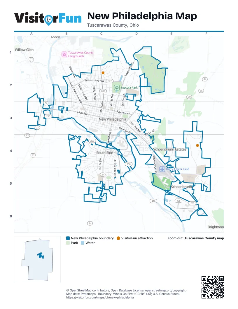
Street index of New Philadelphia
Each street on the sheet and the grid squares it crosses.
- East High AvenueC3, D3, D4, E4, E5, F5, F6
- 4th Street NorthwestC1, C2, C3
- West High AvenueA3, B3, C3
- South Broadway StreetC3, C4, C5
- Graff Road SoutheastC4, D4
- Beaver Avenue NortheastD3
- State Route 39D3
- Tuscarawas Avenue NorthwestB2, B3, C3
- Reiser Avenue SoutheastE6, F6
- Commercial Avenue SoutheastC4, D4, D5
- North Broadway StreetC2, D2, C3
- Seven Mile DriveD1, D2
- South Tuscarawas AvenueB2
- Wabash Avenue NorthwestB2, C2, D2
- Ray Avenue NorthwestB2, B3, C3
- Delaware Drive SoutheastD4, E4, E5
- University Drive NortheastE5, F5
- Ray Avenue NortheastC3, D3, D4
- Mill Avenue SoutheastC4, D4
- Oldtown Valley Road SoutheastC5, C6
- 21st Street SoutheastE5, E6
- Stone Creek Road NorthwestA3
- Brightwood Road SoutheastF6
- 22nd Street SoutheastE5
- Stonecreek Road NorthwestA3
- Baltzley Valley Road SoutheastF6
- Tech Park Drive NortheastE3, F3, E4, F4, F5
- Front Avenue SouthwestB3, C3
- 3rd Street NorthwestC2, C3
- 2nd Street NorthwestC2, C3
- 5th Street NorthwestC2, C3
- Kelly Street NorthwestC2, C3
- 3rd Street SoutheastD3, C4, C5
- Fair Avenue NortheastC3, D3, D4
- Ashwood Lane NortheastC3, D3, D4
- Mall Parking Ring RoadC4, D4
- Bank Lane SoutheastC3, D3, D4
- 2nd Street SouthwestC3, C4, C5
- Commercial Avenue SouthwestB4, C4
- 3rd Street SouthwestC3, C4, C5
- Fair Avenue NorthwestC3
- Miller Avenue NorthwestB2, C2
- Beech Lane NorthwestB3, C3
- 3rd Street NortheastD2, D3
- Park Avenue NorthwestB2, C2
- 4th Street SouthwestC3, C4
- Kaderly Street NorthwestC2
- Union Avenue NorthwestB2, C2, C3
- Cedar Lane NorthwestB2, C3
- 12th Street NorthwestB2, B3
- Goshen Avenue SoutheastC4, C5
- 2nd Drive NortheastD2, D3
- Allen Lane SouthwestC3
- 11th Street NorthwestB2, B3
- Hilan Avenue SouthwestC4, B5, C5
- Mill Avenue SouthwestC3, C4
- 6th Street NorthwestC2, C3
- 2nd Street NortheastD2, C3, D3
- 2nd Street SoutheastC3, C4
- Maple Avenue NorthwestB3, C3
- Allen Lane SoutheastC3, D3, D4
- Bowers Avenue NorthwestB2, C2
- Ashwood Lane NorthwestC3
- Chauncey Avenue NorthwestC1, C2
- 4th Street SoutheastD3, C4, C5
- Bank Lane SouthwestC3
- 5th Street SouthwestC3, C4, C5
- Prospect Street NorthwestB2
- Oak Street NorthwestC1, C2
- Donahey Avenue NortheastD2
- Terrace Road NorthwestC1, D1
- 4th Drive NorthwestC2, C3
- 1st Drive NorthwestC2, C3
- Jefferson Street SoutheastC4, C5
- Minnich Avenue NorthwestC2
- Church Avenue SouthwestC4
- 2nd Drive NorthwestC2, C3
- Front Avenue SoutheastC3, D3
- 1st Drive NortheastD2, C3
- Lakeview Road NorthwestD1, C2, D2
- Schoenbrunn Drive NortheastE4
- Gooding Avenue NorthwestC2
- Hillcrest Drive NortheastD2
- Glen Drive NortheastD2
- Trumpet Drive NortheastF4, F5
- Donald Drive SouthwestB4, C4
- Oak Shadows Drive NortheastD2, E2
- Hardesty Avenue NorthwestB2, C2
- Springbrook Drive SouthwestC5
- 5th Drive NorthwestC2, C3
- Carrie Avenue NorthwestC2
- Baker Avenue NorthwestB2, C2
- 2nd Drive SoutheastC3, D3, C4
- Park Lane Drive NorthwestD2
- 16th Street NortheastE4
- Lewis Avenue NorthwestC2
- Orchard Avenue NorthwestB2, C2
- Cookson Avenue SoutheastC4, D4
- Clubside Drive NorthwestC1
- Saint Clair Avenue SouthwestC3
- Cedar Lane NortheastC3, D3
- Hilltop RoadC1, C2
- Monroe Street NorthwestC2
- PGA Boulevard NortheastD1, E1
- Blake Avenue SouthwestB4, C4
- 11th Drive NorthwestB2
- Pleasant Hill Road NorthwestA3
- Buckeye Street NortheastF5
- Lockport Avenue SouthwestB4, C4
- 1st Drive SoutheastC3, C4
- Sherman Avenue NorthwestB2
- Springbrook Drive SoutheastC5
- 5th Street SoutheastC5
- 3rd Drive SoutheastD3, C4
- Stratton Avenue SouthwestC4, B5
- 4th Street NortheastD2, D3
- 10th Drive NorthwestB2, B3
- Providence Avenue SoutheastC5
- Ross Avenue NorthwestC2
- Kevin Court NortheastF5
- Skinner Drive SoutheastD4
- Grant Avenue NorthwestB3
- Union AvenueB2
- 10th Street NorthwestB2, B3
- North Avenue NortheastC3, D3
- Bluebell Drive NorthwestB2, B3
- Pinebluff Drive NortheastE2
- Moore Avenue NorthwestC2
- Snazzy Circle SouthwestC4
- 6th Drive NorthwestC3
- Fairway Drive NortheastE1, D2, E2
- 3rd Drive NorthwestC3
- Minnich Avenue NortheastC2, D2, D3
- 1st Drive SouthwestC3
- Sea Gull Drive SoutheastD4
- Church Avenue SoutheastC4
- Grandview Avenue NorthwestC2
- Rolland Avenue NortheastE4
- 6th Street NortheastD3
- Concord Circle SoutheastC5
- Independence Circle SoutheastC5
- Jordon Drive NorthwestB2
- Hillandale Road NortheastD2
- Canal Avenue SoutheastC4
- Crestview Avenue SouthwestC5
- Crider Avenue NortheastD3
- Hicks Avenue NortheastE4
- Logan Street NorthwestB2, C2
- Larkin Drive SouthwestC4, C5
- Gulf Stream Lane SoutheastD4
- Robinson Drive SoutheastE6
- 4th Drive SouthwestC3
- 2nd Drive SouthwestC3
- 3rd Drive SouthwestC3
- 5th Street NortheastD3
- Dale Lane NorthwestC3
- Beech Lane NortheastC3, D3
- Creekside Road SoutheastC5
- 18th Street SoutheastE4
- Gasser Circle SoutheastC5
- Mistee Drive SouthwestC4
- Denise Drive NortheastF5
- 8th Drive NortheastD4
- 7th Street NorthwestC3
- Quake Court SouthwestC4
- Goshen Hill Road SoutheastC5
- Seneca Avenue SouthwestC5
- Shelmar Drive SoutheastD4
- Llanfair Lane NorthwestC1, D1, C2, D2
- Steele Hill Road SouthwestB4
- Hance Avenue NorthwestC2, C3
- Compass Circle SoutheastD4
- Ellen Avenue SouthwestC4
- School Bus LoopD2, D3
- Perry Drive SouthwestC5
- Lighthouse Point SoutheastD4
- Tuscora Avenue NorthwestC2, D2
- 7th Street SouthwestC3
- Hummel Avenue SouthwestC4
- Goshen Glens Drive SoutheastC5
- Crider Avenue Rear NortheastD3
- 6th Drive SouthwestC3
- Belmont Avenue NorthwestC2
- 6th Street SouthwestC3
- Bluebell Drive SouthwestB3
- Aspen Lane NorthwestB3
- Gilgen Avenue NortheastD2
- 9th Street NortheastD4
- North Avenue NorthwestC3
- 3rd Drive NortheastD3
- Maiden LaneB2
- 9th Drive NortheastD4
- Emmet Avenue NorthwestB2
- Martin StreetB2
- Township Highway 636B2
- Mulberry Street SoutheastD4
- Southwood Drive SouthwestB4
- Schell Avenue NorthwestB2
- WindchasersD4
- Hickory Drive SoutheastC4
- Prysi ParkwayC5
- Countryside Road NorthwestC2
- Colonial Avenue SoutheastC4
- Oxford Drive SouthwestC5
- Thomas Drive SouthwestB4
- Marlin Lane SoutheastD4
- 8th Street NortheastD3
- Forbes Street NortheastD3
- Jaycee Street NorthwestC2
- 6th Drive SoutheastD3
- Darrell Drive NortheastD2
- Kent Circle NortheastE4
- Providence Drive SouthwestC5
- Saint Clair Avenue SoutheastC3
- Shiloh Lane NorthwestB2, C2
- Bryan Circle NortheastE4
- Patio Lane NorthwestB3
- 4th Drive SoutheastD3
- Adan Avenue SouthwestC4
- James Street NorthwestB2
- Ackey Street NorthwestC2
- 4th St Extended SoutheastD3, D4
- Zella Avenue NorthwestC2
- Court Avenue NorthwestC2
- Ray Avenue Rear NortheastD3
- Strawberry Lane NorthwestC2, C3
- Bob Harris Avenue SouthwestC5
- Bimini Lane SoutheastD4
- Sycamore Circle SoutheastC5
- Poplar Avenue NorthwestC3
- McDonald Drive NorthwestB3
- Clay Avenue SoutheastC4
- Brookside Drive NortheastF5
- Avon Avenue SouthwestC5
- 8th Street SouthwestB3
- 9th Street SouthwestB3
- Beitler Avenue NortheastD3
- 5th Drive SouthwestC3
- Ohio Avenue NorthwestC2
- Kaserman Avenue NortheastD3
- Ridge Avenue NortheastD3
- Dawson Lane NorthwestC3
- 12th Street NortheastD4
- Fair Avenue RearD3
- Sycamore Street SoutheastC4, C5
- 10th Street NortheastD4
- Winspear Drive SoutheastD4
- Sandlewood Drive SoutheastC5, C6
- Hazelwood Drive SouthwestC5
- Sandpiper Drive SoutheastD4
- Port Lane SoutheastD4
- Leo Benjamin CourtC3
- Coral Key Drive SoutheastD4
- Driftwood Drive SoutheastD4
- Whispering Pines NortheastD1
- Dort Lane NorthwestC2, C3
- 7th Street NortheastD3
- Pr43987 PdD2
- College AvenueB2
- Goettge Avenue NortheastE4
- Ester Court NorthwestC2, C3
- Pine LaneD4
- Deitrich DriveD4
- York Drive SoutheastC5
- HollyD4
- Juniper Street SoutheastD4
- Sailfish Lane SoutheastD4
- Taylor Drive SouthwestC4
- 11th Street NortheastD4
- Summit Avenue NortheastC2, D2
- 24th Drive NortheastF5
- Dogwood Street SoutheastD4
- Rosch Court SouthwestC4
- 7th Drive SoutheastD3
- 21st Drive NortheastF5
- Gibbs Avenue SouthwestC4
- 10th Street SouthwestB3
- 7th Drive NortheastD3
- 7th Drive SouthwestB3, C3
- Rankin Court SouthwestB4, C4
- Meadowbrook Drive SouthwestC5
- Springwood Circle SouthwestC5
- Fairhill Road NortheastD2
- Willow Street SoutheastD4
- Streb Drive NorthwestB3
- Walden Court SouthwestC5
- 8th Street Extended SouthwestB3
- Myers Avenue SouthwestC4
- Tell Street SoutheastD4
- 9th Street NorthwestB3
- Emmet AvenueB2
- Pompano Lane SoutheastD4
- Dolphin Drive SoutheastD4
- Lake Street NorthwestC2
- Pleasant Valley Road NortheastE1
- Watson Circle NortheastD2
- Cypress Circle SoutheastC4
- Carmella Drive NorthwestC2
- Marsh CourtB2
- Lawver Hass Drive SoutheastC5
Things to do on the New Philadelphia map
Places on the map
- Akron Children's Hospital - New Philadelphia Health Center
- ALDI
- Applebee's
- Applied Behavioral Connections
- Aviation Center
- Best Western
- Bob Evans
- Buehler's Fresh Foods
- Burger King
- Calvary Cemetery
- Central Elementary School
- Church of the Brethren
- Church of the Nazarene
- Denny's
- Dollar General
- East Avenue Cemetery
- East Elementary School
- Fair Street Cemetery
- Hampton
- Harbor Freight Tools
- Harry Clever Field
- Heritage Country Store
- Hog Heaven
- Holiday Inn Express & Suites
- Kent State University Tuscarawas
- Lam's Oriental Cusine and Buffet
- Lowe's
- New Philadelphia Post Office
- New Towne Mall
- Oak Shadows Golf Club
- Quaker Stadium
- South Elementary School
- Tuscarawas County Law Library
- Tuscarawas County Public Library
- Tuscora Park
- Walmart Supercenter
Next to New Philadelphia
- Brightwood
- Dover map
- Schoenbrunn
- Willow Glen
© OpenStreetMap contributors, Open Database License, openstreetmap.org/copyright · Map data: Protomaps · Boundary: Who's On First (CC-BY 4.0); U.S. Census Bureau















