

Ohio map
Niles map
About 18,238 people live here (Census Bureau, 2024 estimate). The sheet's index lists 300 streets; Youngstown Warren Road, Robbins Avenue and South Main Street cross the most grid squares. Things to do inside the boundary: Eastwood Mall.
Open the map (PDF, US Letter)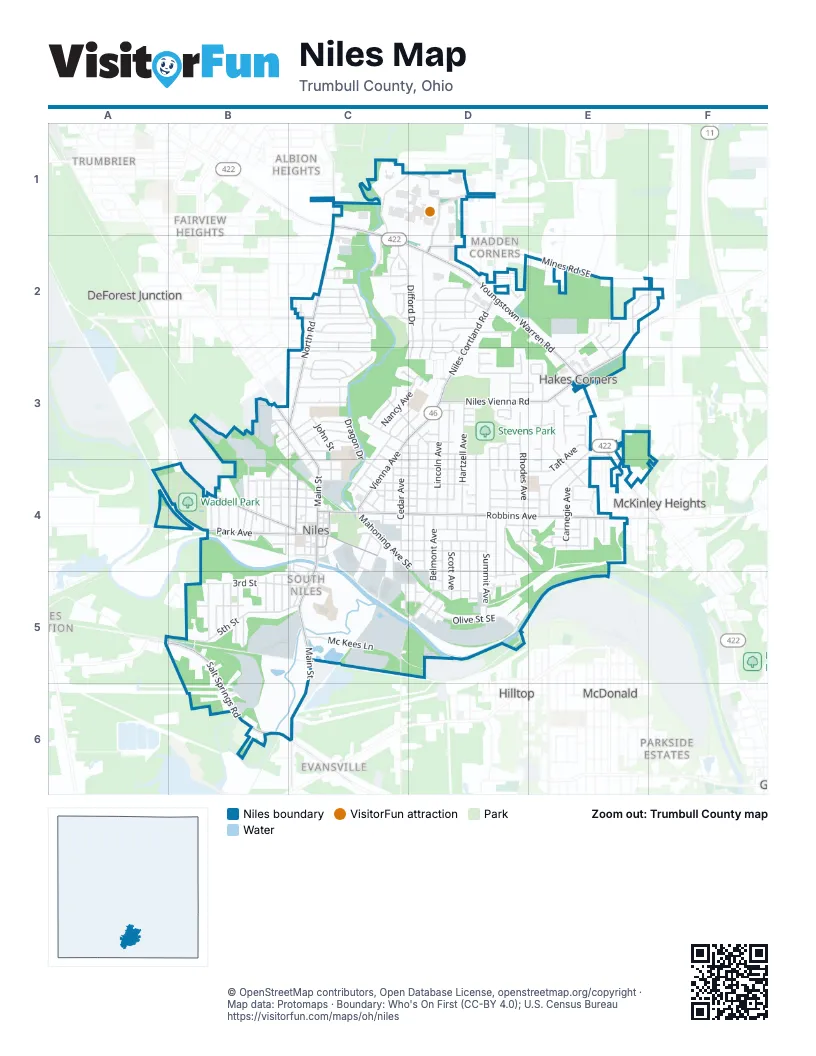
Street index of Niles
Each street on the sheet and the grid squares it crosses.
- Youngstown Warren RoadC1, C2, D2, E2, E3, E4
- Youngstown Road SoutheastC1
- Robbins AvenueC4, D4, E4
- South Main StreetC4, C5, C6
- Niles Cortland RoadD2, D3
- North Main StreetB3, C3, C4
- Vienna AvenueC3, D3, C4
- Niles Cortland Road SoutheastD2
- Niles Vienna RoadE2, D3, E3
- Salt Springs RoadB5, B6, C6
- North RoadC1, C2, C3
- West Park AvenueA4, B4, C4
- Warren AvenueB4, C4
- Mines Road SoutheastD2, E2, F2
- East Park AvenueC4
- North Chestnut AvenueC4
- East State Street SoutheastC4
- North Road SoutheastC1
- Deforest Road SoutheastC2
- Shaker Boulevard SoutheastD1, D2
- Eastwood Mall BoulevardC1, D1, C2
- Summit AvenueD4, D5
- Belmont AvenueD4, C5, D5
- Arms BoulevardD3
- Washington Avenue SoutheastC3, D3, D4
- Olive Street SoutheastC5, D5
- West 3rd StreetB5, C5
- Difford DriveC2, D2, D3
- Lincoln AvenueD3, D4
- 5th StreetB5, C5
- Hartzell AvenueD3, D4
- Bentley AvenueD3, D4
- Mason StreetC4, D4
- Gypsy LaneD2, D3
- North Rhodes AvenueD3, D4
- Clinton StreetC4, D4
- Old Forge Road SoutheastD2, D3
- Mc Kees LaneC5
- Trumbull AvenueC2, C3
- Hogarth Avenue SoutheastD3, D4
- Frederick StreetD2, C3, D3
- Carnegie AvenueE4
- Pearl StreetC4, D4
- Lafayette Avenue SoutheastD3, D4
- Great East Plaza SoutheastD1, D2
- Roosevelt Avenue SoutheastE3, E4
- Fenton StreetC4, D4
- Hunter AvenueB3, B4
- Ann AvenueD4, D5
- Mahoning Avenue SoutheastC4, D4
- Sharkey DriveB4
- Belle Terre AvenueE3, E4
- Hughes Street SoutheastC3, D3
- Moreland Road SoutheastD2
- North Cleveland AvenueD3, D4
- West Federal Street SoutheastB3, C3, C4
- Sheridan Avenue SoutheastB4
- Henry Street SoutheastD4, D5
- Taft AvenueE3, D4, E4
- Dragon DriveC3, C4
- Bonnie Brae AvenueE3, E4
- Cherry AvenueD3, D4
- John StreetC3, C4
- West StreetC3, C4
- North Cedar AvenueC3, C4
- Fairlawn Avenue SoutheastC3
- Russell AvenueD4, D5
- Lawnview Avenue SoutheastC2
- Pepperwood DriveD3
- Camrose Drive SoutheastC2
- Maple Street SoutheastB4, C4
- North Crandon AvenueD3, D4
- Scott AvenueD4, D5
- South Cleveland AvenueD4, D5
- Mc Roberts Road SoutheastA4, B4
- Clark StreetD4, E4
- Walnut Street SoutheastC4, C5, D5
- Orchard AvenueD3, D4
- Baldwin AvenueD4, D5
- High Avenue SoutheastD4, D5
- Stepney Street SoutheastD4, E4
- Mill Creek Road SoutheastD2
- Peffer Avenue SoutheastD4, D5
- Wood Avenue SoutheastD4
- Fulton StreetD4
- Indiana AvenueB5
- Wilson AvenueC3
- Holford Avenue SoutheastC4
- East Federal StreetC4
- Bentwillow Drive SoutheastC3
- Woodland Chase BoulevardC3, D3
- Butterfield CircleD3, E3
- Smith Street SoutheastB4, C4
- Nancy AvenueC3, D3
- Hyde Avenue SoutheastB4
- Black Oak DriveE2, E3
- Harris StreetC4, D4
- Helen AvenueC3
- South StreetD4
- Oak Forest DriveE2, F2
- Royal Mall DriveD2
- Woodglen AvenueC3
- Brentwood BoulevardD2, D3
- Summerberry LaneC2
- North Arlington AvenueC4
- Morningside RoadC2
- Park Place DriveD3
- Kearney Street SoutheastD4, E4
- Saint John AvenueC3
- Deer TrailE2, F2
- Cassandra DriveC3
- Pratt Street SoutheastC4, C5
- Cynthia CourtC3
- Wyoming AvenueB5
- Phoenix PlaceD2
- Ford Street SoutheastC4, D4
- Grant Street SoutheastC4, C5
- Potomac AvenueC2
- West State Street SoutheastB4, C4
- Sayers Avenue SoutheastB4
- Ward Avenue SoutheastC4, C5
- North Langley Street SoutheastC4
- Park DriveC1, C2
- Williams Street SoutheastB4, C4
- George StreetC3
- East DriveC2, D2
- Allison StreetC4, D4
- Jackson Alley SoutheastC4, D4
- Eliza Avenue SoutheastC4, C5
- Dakota AvenueB5
- Emma StreetB4
- Youll StreetD4, E4
- Mistletoe Road SoutheastC2
- James StreetE4
- Liberty StreetC3, C4
- Blossom LaneC3
- Stanton Avenue SoutheastB5
- Shadow Ridge DriveE3
- South Cedar AvenueC4
- Shaw RoadD2
- Sherman Avenue SoutheastB5
- Iowa AvenueB5
- Liberty Street SoutheastC2, C3
- Highland Avenue SoutheastB4
- Nash AvenueB5
- East Woodland AvenueC3
- Bowman StreetC3, D3
- Lakeview Road SoutheastC2
- Andrea BoulevardD3
- Sunny Estates DriveE3
- Ohio AvenueB4
- Cardigan StreetE4
- Morse Avenue SoutheastC4
- Hiram StreetE4
- Mc Donald Avenue SoutheastE4
- Hazel StreetE4
- Tripodi CircleE3
- Beaver AvenueC4
- Mc Kinley Avenue SoutheastD5
- North Pleasant Avenue SoutheastB4
- Valley BoulevardC2
- Battles AvenueB5
- Clay StreetC5
- Depot StreetC4, C5
- Poplar Avenue SoutheastE4
- Nebraska AvenueB5
- Lantern LaneD3
- Neil Street SoutheastC4
- East Madison AvenueC4
- Thomas Street SoutheastD5
- Plant Street SoutheastB4, C4
- Pheasant RunE3
- Nob Hill DriveE2, E3
- Gilbert Avenue SoutheastD4
- Victor Avenue SoutheastB4
- Wade AvenueC3
- South Rhodes AvenueD4
- Cannon StreetC4, D4
- Higley Avenue SoutheastE4
- Hillcrest AvenueD4
- Ravine Court SoutheastD4, E4
- Hickory Street SoutheastC4, D4
- Carle AvenueD5
- North Clover AvenueB4
- Pine Alley SoutheastC4
- Griffin StreetD3
- Franklin AvenueC4
- Morris Place SoutheastC2
- West 2nd StreetC4, C5
- Bellvue DriveD4, E4
- Linden Avenue SoutheastC4
- Erie StreetC4
- Oxford AvenueB5
- Water Street SoutheastC4
- West 1st StreetC4, C5
- Meadowlark LaneE3
- West Church StreetC4
- East Margaret Avenue SoutheastC3
- Evans Street SoutheastC4
- Anderson Morris RoadE3
- North Union WayB4
- Reno Street SoutheastD4
- Franklin Alley SoutheastC4
- South Arlington AvenueC4
- South Chestnut AvenueC4
- 4th StreetB5
- Gracewoods DriveE3
- West Margaret Avenue SoutheastB3, C3
- Asbury LaneC2, D2
- Four Winds CourtD3
- South Butler AvenueB4
- Oak Knoll Street SoutheastD4, D5
- Spring AvenueD5
- Short Street SoutheastC4
- East Church StreetC4
- Elm StreetB5
- Isaac Avenue SoutheastD3, D4
- Brown StreetC5
- Fairview Avenue SoutheastE4
- Price Street SoutheastC5, D5
- Penn Avenue SoutheastC4
- Wendell Place SoutheastC2, D2
- Roberts Street SoutheastC3
- Emmet Street SoutheastB3, C3
- Sandel Wood DriveE2
- Phillips Avenue SoutheastD4, E4
- Bean StreetC4, D4
- Seneca Street SoutheastC4
- Prospect StreetB5, C5
- Bond StreetC4
- North Bentley AvenueD4
- Laurel StreetC2, C3
- Blaine StreetC3, C4
- Ambrose AvenueD4
- South Crandon AvenueD4
- Wayne Street SoutheastC3
- Davis Street SoutheastC3, D3
- Mauro Circle SoutheastC2
- Bruce CourtD4
- Pine Oak CourtE2
- Palm Street SoutheastC4
- Windward WayD3
- Leslie AvenueC4
- Sayers CourtC4
- Spruce St St SoutheastE3
- Sullivan Street SoutheastD3
- Belair CourtB5
- Heaton Boulevard SoutheastC3
- Steel StreetB3
- Banyan LaneD3
- McEvoy CourtD4
- Higgins Avenue SoutheastB3, C3
- Ardmore CourtC3
- 5th Street BridgeB5
- Taylor Avenue NorthwestB3
- Third StreetE3
- Vine Court SoutheastB4
- Holtz Street SoutheastD3
- Barclay StreetD3
- Near StreetD3
- West Madison Avenue SoutheastC4
- West Woodland AvenueC3
- Buckeye LaneC2
- East 1st StreetC5
- East 2nd StreetC5
- East 3rd StreetC5
- Harmon AvenueE4
- Robbins StreetC5
- Summit Avenue SoutheastD5
- Horace Street SoutheastD5
- Frances Avenue SoutheastC4, C5
- Estelle Court SoutheastD4
- Forrest Street SoutheastD5
- North Butler AvenueB4
- Deer Trail CourtF2
- Circle StreetC4
- Fenton Street SoutheastC4
- Spruce CourtE3
- Timber CourtE4
- Cardinal CourtE3
- Brook StreetC4
- Pew Street SoutheastD5
- Brandywine Drive SoutheastD2
- Sophia CourtD3
- Elaine Court SoutheastE4
- Johnny Cake Road SoutheastD2
- South Union WayB4
- Celia CourtE3
- South Pleasant Avenue SoutheastB4
- Wagstaff Avenue SoutheastB4
- Diane CourtC2
- Donna CourtC3
- Robin CourtE3
- Merlo CourtE3
- Jones Avenue SoutheastB3
- Griffin CourtD3
- Calvin Place SoutheastC2
- East Pointe Drive SoutheastE2
- Railroad StreetC4
- Youll AvenueE4
Things to do on the Niles map
Places on the map
- AimPoint Airsoft
- American Eagle Outfitters
- Amish Kitchen
- Applebee's
- At Home
- Bass Pro Shop - Boat Storage
- Bath & Body Works
- Best Buy
- Bibibop
- Bins A Plenty
- BMV Driver Testing Course
- Bo Rein Stadium
- Bob Evans
- Books-A-Million
- Boscov's
- Boulevard Centre
- Buckle
- Buffalo Wild Wings
- Burger King
- Busy Bees Pottery & Arts Studio
- Captain McFinn
- Casal Aveda Institute
- Chase
- Coral Rose Boutique
- CVS Pharmacy
- Eastwood Field
- Eastwood Mall
- Great East Plaza
- Kennedy Park
- Lincoln Elementary School
- McKinley Centre
- McKinley Memorial Library
- Niles Middle School
- Niles Trailhead Park
- Niles Union Cemetery
- Stevens Park
- The Village Center
- Waddell Park
- Weathersfield Township
Next to Niles
- Albion Heights
- Bolindale
- DeForest
- DeForest Junction
- Evansville
- Fairlawn Heights
- Fairview Heights
- Hilltop
- Howland Terrace
- Madden Corners
- McDonald
- McKinley Heights
- Parkside Estates
- Tibbetts Corners
- Trumbrier
- Trumbull Homes
© OpenStreetMap contributors, Open Database License, openstreetmap.org/copyright · Map data: Protomaps · Boundary: Who's On First (CC-BY 4.0); U.S. Census Bureau















