

Ohio map
Piqua map
About 20,940 people live here (Census Bureau, 2024 estimate). The sheet's index lists 300 streets; North County Road 25A, Troy–Sidney Road and Maplewood Drive cross the most grid squares. Things to do inside the boundary: Piqua Historical Area.
Open the map (PDF, US Letter)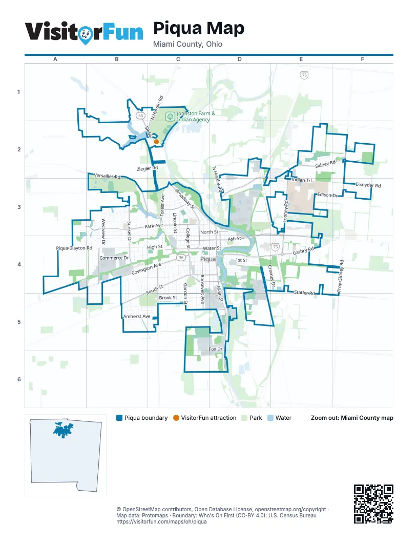
Street index of Piqua
Each street on the sheet and the grid squares it crosses.
- Demming RoadB1
- Hardin Alternate RoadB1
- SR 66B1, B2, C2
- North Hardin RoadC1, B2, C2
- Versailles RoadB2, B3
- Ziegler RoadC2, B3
- North Country Club RoadD2, D3
- North County Road 25AD2, F2, D3, D6
- Scarbrough DriveD2
- Sidney RoadD2, E2, F2
- CherokeeE2
- Chinook PassE2
- Delaware CircleE2
- Indian Ridge DriveE2
- Kiowa CourtE2
- Looney RoadE2, E3, E4
- Nadene DrE2
- Navajo TrailE2
- Ottawa CirE2, F2
- Seminole WayE2
- Sioux DriveE2
- Tomahawk TrailE2, E3
- Troy–Sidney RoadF2, F3, F4, F5
- Park AvenueA3, B3, C3
- Whitetail LaneA3, B3
- Alpha DriveB3
- Anderson StreetB3, C3
- Antler CourtB3
- Bear RunB3, B4
- Beckert DriveB3
- Blackwell DriveB3
- Britton DriveB3
- Caribou CourtB3
- Carlyle DriveB3
- Carol DriveB3
- Catalpa DriveB3, B4
- Clifton DriveB3
- Colleen DriveB3
- Coronada CourtB3
- Deerwood DriveB3, B4
- Eagles Lake DriveB3
- Eagles WayB3
- East Parkway DriveB3
- Echo Lake DriveB3, C3
- Echo Lake RoadB3
- Falcons Nest CourtB3
- Fawn CourtB3
- Gleneagle CourtB3
- Golden Eagle CourtB3
- Green Briar CourtB3
- HillcrestB3
- Kestrel CourtB3
- Lakeridge PlaceB3
- Lambert DriveB3, B4
- Lenox StreetB3, C3
- Maplewood DriveB3, C3, B4, C4
- Moffett RoadB3
- Mote LaneB3
- North Bennett DriveB3
- North Parkway DriveB3, B4
- North Sunset DriveB3, B4
- Omega DriveB3
- Orchard DriveB3
- Osprey CourtB3
- Peregrine PlaceB3
- Red Deer TrailB3
- Ridgeway AvenueB3
- Spotted Doe CourtB3, B4
- Stratford DriveB3
- Westview DriveB3, B4
- Wilshire DriveB3, A4, B4
- Ann StreetC3
- Boone StreetC3
- Broadway StreetC3, C4
- Caldwell StreetC3, C4
- Camp StreetC3
- Cherry StreetC3
- Drexel AvenueC3
- Elm StreetC3
- Fisher DriveC3
- Forest AvenueC3
- Fountain BoulevardC3
- Franklin StreetC3, C4
- Gill StreetC3
- Hopewood DriveC3
- Lake StreetC3
- Lakewood PlaceC3
- Lincoln StreetC3, C4
- Lindsey StreetC3
- Madison AvenueC3
- Maple StreetC3
- Marymont DriveC3, C4
- Nicklin AvenueC3
- North College StreetC3, C4
- North Downing StreetC3, C4
- Riverside DriveC3, D3
- Robinson AvenueC3
- Rundle AvenueC3, D3
- Scott StreetC3
- Scudder StreetC3
- Short DriveC3, C4
- Vine StreetC3
- Virginia StreetC3, C4
- Walker StreetC3, C4
- Walnut StreetC3, C4
- Washington AvenueC3, C4
- West North StreetC3, D3
- Camaro CourtD3
- Chevy LaneD3
- East Ash StreetD3, E3, D4, E4
- East Greene StreetD3, D4
- East North StreetD3
- Harrison StreetD3, D4
- Hollow ParkD3
- Industry Park DriveD3
- Innovation ParkwayD3
- Manning StreetD3, D4
- Mound StreetD3
- New StreetD3, D4
- North Hetzler RoadD3
- North Main StreetD3, D4
- North Wayne StreetD3, D4
- Scott DriveD3
- Sherry DriveD3
- Spring StreetD3, D4
- Steelway PlaceD3
- Van WayD3
- Zimmerlin RoadD3
- Career DriveE3
- Christine LaneE3
- Edison DriveE3, F3
- Eleanor AvenueE3
- Indian TrailE3
- Jill CourtE3
- Kienle DriveE3, E4
- Laura DriveE3
- Seidel ParkwayE3
- Springbrook LaneE3
- Woodlawn DriveE3
- East Snyder RoadF3
- Deerfield CrossingA4, B4
- Piqua-Clayton RoadA4, B4
- Sambor CourtA4
- Spiker RoadA4, A5
- Beverly DriveB4
- Brentwood AvenueB4, B5
- Commerce DriveB4
- Covington AvenueB4, C4
- Dubois DriveB4
- Edge StreetB4, C4
- Elmwood CircleB4
- Fallow CourtB4
- Garfield StreetB4, C4
- Glenwood AvenueB4, B5
- Janet StreetB4
- Jean StreetB4
- Lyndhurst StreetB4
- Margene DriveB4, C4
- Marwood DriveB4, C4
- Maryville LaneB4
- Parkridge PlaceB4
- Peters DriveB4
- Pinewood AvenueB4, B5
- Propeller PlaceB4
- Robert M. Davis ParkwayB4
- Severs DriveB4, C4
- Sharon DriveB4
- Sherwood StreetB4
- South Sunset DriveB4, B5
- West Grant StreetB4, C4, D4
- West High StreetB4, C4, D4
- West Parkway DriveB4
- Adams StreetC4
- Blaine AvenueC4, C5
- Boal AvenueC4, C5
- Brice StreetC4, C5
- Buckeye StreetC4
- Cassell StreetC4
- Cedarbrook DriveC4
- Commercial StreetC4, D4
- Cottage AvenueC4, C5
- Downs StreetC4
- Ellerman StreetC4
- Fisk StreetC4, C5
- Ford DriveC4
- Garnsey StreetC4, D4
- Glenn StreetC4
- Gordon StreetC4, C5
- Gray StreetC4
- Hancock StreetC4
- Harney DriveC4
- Jackson StreetC4
- Kitt StreetC4
- Leonard StreetC4, C5
- Levering DriveC4
- Linden AvenueC4, C5
- Martz StreetC4
- McKinley AvenueC4, C5
- Miami StreetC4, D4
- Morrow AvenueC4
- Mote Park SpurC4
- Mulberry StreetC4
- North Roosevelt AvenueC4
- Orr StreetC4
- Plum StreetC4
- Renche StreetC4
- Ridge StreetC4
- Ron Air DriveC4
- Sheridan StreetC4
- Sherman StreetC4
- South College StreetC4
- South Downing StreetC4, D4, D5
- South Roosevelt AvenueC4, C5
- South StreetC4, D4, B5
- Steele AvenueC4
- Summit StreetC4
- Sycamore StreetC4
- Upway DriveC4
- Weber StreetC4
- West Ash StreetC4, D4
- West Greene StreetC4, D4
- West Water StreetC4, D4
- Willard StreetC4, C5
- Wilson AvenueC4, C5
- Wood StreetC4, D4
- Y StreetC4
- Young StreetC4, D4
- 1st StreetD4
- 2nd StreetD4
- 3rd StreetD4
- 4th StreetD4
- 5th StreetD4
- Armory DriveD4
- Bridge StreetD4, D5
- Carr StreetD4
- Cleveland StreetD4
- Cromes DriveD4, E4
- East Grant StreetD4
- East High StreetD4
- East Main StreetD4
- East StreetD4
- East Water StreetD4
- Garbry RoadD4, E4
- Harvard StreetD4
- Hilliard StreetD4
- Home AvenueD4
- Johnson StreetD4
- Long DriveD4
- Manning AvenueD4
- Market StreetD4
- Ohio StreetD4
- Race StreetD4
- South Main StreetD4, D5, D6
- South Wayne StreetD4, D5
- Staunton StreetD4
- West Statler RoadD4, E4, E5, F5
- Yale StreetD4
- Almeda CourtE4
- Heritag PlaceE4
- McDowell DriveE4
- Patrizio PlaceE4
- Recker RoadE4
- Amesbury CourtB5, C5
- Amherst AvenueB5, C5
- Andover AvenueB5, C5
- ArrowheadB5, C5
- Briarcliffe AvenueB5
- Brown RoadB5
- Cambridge StreetB5
- Candlewood BoulevardB5
- Chicksaw WayB5, C5
- Concord AvenueB5
- Dover AvenueB5
- Fairfax AvenueB5, C5
- Falmouth RoadB5
- Haverhill DriveB5
- Marlboro AvenueB5
- New Haven RoadB5
- Rutland RoadB5
- Sweet Briar AvenueB5, C5
- Williams PlaceB5
- Woodridge CourtB5
- Brook StreetC5
- Clark AvenueC5, D5
- Drake RoadC5
- Electric AvenueC5
- Fox DriveC5, D5
- Hemm RoadC5, D5
- Jed WayC5
- Manier AvenueC5
- Plymouth AvenueC5
- Washington RoadC5
- Hemm AvenueD5
- Lee AvenueD5
- Meteor DriveD5
- Piqua-Troy RoadD5
- Statler AvenueD5
- Windham WayD5
- East Statler RoadF5
- Troy-Sidney RoadF5
Things to do on the Piqua map
Places on the map
- ALDI
- Alexander Stadium
- BK Rootbeer Stand
- Bob Evans
- Buffalo Wings & Rings
- Cedar Hill Cemetery
- Cinemark Miami Valley
- Cracker Barrel
- Crooked Handle Brewing
- Duke Foundation Disc Golf
- Echo HIlls Golf Course
- Echo Lake
- Edison State Community College
- First Church of God
- Fountain Park
- Franz Pond
- French Park
- Goodrich Giles Park
- Hardman Field
- Heritage Green
- Hollow Park
- Johnston Farm & Indian Agency
- Johnston Farm Museum
- Johnston Home
- Kroger
- Lock 9 Park
- Luckys Pad
- McDonald's
- Mote Park
- Nicholas School
- Piqua Center
- Piqua City Hall
- Piqua High and Junior High Schools
- Piqua Low Head Reservoir
- Piqua Post Office
- Pitsenbarger Park and Sports Complex
- Swift Run Lake
- Upper Fountain Park
- Upper Valley Joint Vocational School
- Walmart Supercenter
© OpenStreetMap contributors, Open Database License, openstreetmap.org/copyright · Map data: Protomaps · Boundary: Who's On First (CC-BY 4.0); U.S. Census Bureau















