

Ohio map
Twinsburg map
About 19,504 people live here (Census Bureau, 2024 estimate). The sheet's index lists 271 streets; Ravenna Road, Darrow Road and Glenwood Drive cross the most grid squares. Also on it: Center Valley Park, Gleneagles Golf Club and Liberty Park Recreation Area.
Open the map (PDF, US Letter)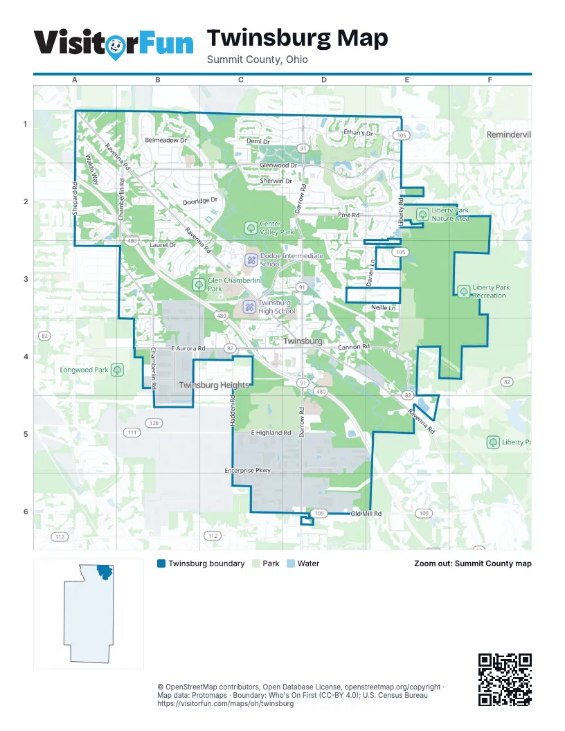
Street index of Twinsburg
Each street on the sheet and the grid squares it crosses.
- Ravenna RoadA1, B1, B2, C3, C4, D4, E4, E5
- Sharonbrook DriveA1, A2, B2
- Waldo WayA1, A2, B2
- Andover DriveB1
- Belfair DriveB1
- Belleau DriveB1
- Belmeadow DriveB1, C1, B2, C2
- Briardale CourtB1
- Buckthorn DriveB1
- Dayflower DriveB1
- Deeplake CircleB1
- Deerfield CourtB1
- Forest Lake DriveB1
- Heritage DriveB1
- Kasserine CourtB1
- Landsdale CircleB1
- Moraine DriveB1, C1
- Parkland DriveB1, B2
- Primrose CircleB1, B2
- Ridgewood DriveB1, B2
- Serene CourtB1, B2
- Silverdale CircleB1
- Springwood CircleB1
- Timber CourtB1
- Tinkers View DriveB1
- Treefern CourtB1
- Woodchuck CourtB1
- Woodland CourtB1
- Chestnut Trail DriveC1, C2
- Demi DriveC1, D1
- Fieldcrest LaneC1, D1
- Logan LaneC1
- Meadowood BoulevardC1, D1
- Parkview DriveC1
- Sandalwood DriveC1, D1
- Scenic View DriveC1, C2
- Trailwood DriveC1
- Van Oaks DriveC1
- Wagner CourtC1
- Waywood DriveC1
- White Marsh DriveC1, D1
- Willow DriveC1
- Brighton CircleD1, E1, D2, E2
- Cobblestone LaneD1
- Corbetts LaneD1
- Darrow RoadD1, D2, D3, D4, D5, D6
- Ethan's DriveD1, E1
- Frederick LaneD1
- Glen Eagle LaneD1
- Hanford LaneD1
- Laura LaneD1
- Luman LaneD1
- Mathers WayD1, E1
- North Pond LaneD1
- Orchard Hill LaneD1
- Oviatt LaneD1
- Palmer LaneD1, E1
- Spring Ridge DriveD1
- Taylor LaneD1
- Thompson Rye CircleD1
- Timothy LaneD1, D2
- White Ash TrailD1
- Aspen LaneE1
- Baldwin LaneE1
- Bissell DriveE1, E2
- Covington LaneE1
- Elisha LaneE1
- Glen OaksE1
- Glenwood DriveE1, B2, C2, D2, E2
- Hoadley LaneE1
- Killingsworth LaneE1
- Liberty RoadE1, E2, E3, E4
- Merriam LaneE1
- Nathaniel LaneE1
- Osborn LaneE1
- Pratt LaneE1, E2
- Riley CourtE1
- Stanley LaneE1
- Upson CourtE1, E2
- Willowbrook DriveE1
- Andrew DriveA2, A3, B3
- Bridget LaneA2
- Chamberlin LaneA2, B2
- Gill CourtA2
- Jennifer DriveA2, A3
- Jessica CourtA2
- Ledge RoadA2
- Melissa CourtA2
- Patton CourtA2
- Patton StreetA2
- Shepard RoadA2
- Shepard TrailA2
- Blossom LaneB2
- Brookhill CircleB2
- Chamberlin RoadB2, B3, B4, B5
- Chamberlin TrB2
- Crestwood DriveB2
- Dooridge DriveB2, C2
- East Idlewood DriveB2, C2
- Edgewood DriveB2, C2
- Gettysburg DriveB2, B3
- Greenway DriveB2, B3
- Heron CoveB2
- Hickory Hill DriveB2
- Hillsdale DriveB2, C2
- Iris Glen DriveB2
- Mallard CoveB2
- Mortus DriveB2
- Newport CoveB2
- Oakwood DriveB2, C2
- Ridge Meadow CourtB2, C2
- Ridgewood CourtB2
- Rolling Hills DriveB2
- Shadywood LaneB2
- Stone Creek LaneB2
- Sunview DriveB2, C2
- Timberland LaneB2
- West Idlewood DriveB2
- Westwood DriveB2, C2
- Croydon RoadC2
- Cynthia DriveC2
- Gary DriveC2
- Haverhill RoadC2, D2
- Nantucket CoveC2
- Olde Pond LaneC2, C3
- Pine Tree LaneC2, C3
- Ridge CourtC2
- Sherwin DriveC2, D2
- Terrace DriveC2
- Warren ParkwayC2, D2
- Bronson's WayD2, E2
- Burton DriveD2, E2
- Champion TrailD2, E2
- Clarius CircleD2
- Darrow Park DriveD2
- Davis WayD2, E2
- Ezra CourtD2
- Firelands DriveD2, D3
- Haggett DriveD2, E2
- Hawkins LaneD2
- Jania WayD2
- Joann PlaceD2
- Lila PlaceD2
- Myrick LaneD2
- Orin WayD2, E2
- Overlook DriveD2
- Parmalee DriveD2, E2
- Post RoadD2, E2
- Putnam CourtD2
- Sikes LaneD2
- Simsbury CourtD2, D3
- Vail DriveD2
- Wallingford DriveD2, D3
- Walton BoulevardD2
- Waterford DriveD2
- Alger TrE2
- Alling DriveE2
- Appleby LaneE2
- Bierce CircleE2
- Country Club CircleE2
- Country Club LaneE2
- Coyote Run TrailE2
- Framingham LaneE2
- Gardner CourtE2
- Huldah DriveE2
- Irene LaneE2
- Kendal LaneE2
- Merino LaneE2
- Tucker CourtE2
- Wilson LaneE2
- Zenas CourtE2
- Ashcroft LaneB3
- Beechmont CourtB3
- Bellaway DriveB3, B4
- Circle Oak SilverB3, B4
- Concord CircleB3
- Dutton DriveB3, B4
- Fairfield DriveB3
- Hermitage DriveB3
- Holmes DriveB3, C3
- Hyde Park DriveB3
- Laurel DriveB3
- Lawnfield DriveB3
- Maplegrove DriveB3
- Merryvale DriveB3, B4
- Monticello DriveB3
- Oakview CourtB3
- Parker LaneB3
- Pinebark PlaceB3
- Presidential ParkwayB3, C3
- Roseland DriveB3
- Strauss LaneB3
- Altamont DriveC3
- Arbor Glen DriveC3, D3
- Clark CircleC3, D3
- Edgebrook CrossingC3, D3
- Heather LaneC3
- Lost Pond DriveC3
- Moorland DriveC3
- Officer Joshua T. Miktarian Memorial ParkwayC3, D3
- Redtail CourtC3
- Trivue CircleC3
- Twin Circle DriveC3
- Whitewood ParkwayC3
- Abrams DriveD3, E3
- Aubrey LaneD3
- Brittney LaneD3
- Cabot WayD3, E3
- Cora CourtD3
- Darien LaneD3, E3
- Darlene CourtD3
- Granby CircleD3
- Hunters RidgeD3
- Max CourtD3
- Sarah CourtD3
- Sharon CourtD3
- Simecek DriveD3, D4, E4
- Veron LaneD3
- Windsor WayD3, E3
- Wyatts WayD3
- Adam RunE3
- Ansonia DriveE3
- Evans WayE3
- Jason DriveE3
- Lister LaneE3
- Neille LaneE3
- Steffan DriveE3
- Sterling CourtE3
- Cornerstone ParkwayB4
- East Aurora RoadB4, C4, D4, E5
- Independence ParkwayB4
- Lockwood OvalB4
- Midway DriveB4
- Oakbrook CircleB4
- Pine Ridge DriveB4
- Ashdale DriveC4
- Birchwood DriveC4
- Buchtel StreetC4
- Burridge CircleC4, D4
- Canyon Falls BoulevardC4
- Commons BoulevardC4
- Hadden RoadC4, C5
- Maple DriveC4, D4
- Twin Hills ParkwayC4
- Whiteoak DriveC4
- Wilcox DriveC4
- Burridge LaneD4
- Cannon RoadD4, E4, E5
- Charles CourtD4
- Church StreetD4
- Connoton AvenueD4
- Creekside DriveD4
- Cross StreetD4
- Depot StreetD4
- Jody Lynn LaneD4
- Richner CourtD4
- South Tinkers LaneD4
- Tinkers LaneD4
- Anthony LaneE4
- Helen LaneE4
- East Highland RoadC5, D5
- Enterprise ParkwayC5, D5
- Edison BoulevardD5
- Herrick RoadE5
- Case Parkway NorthC6, D6
- Case Parkway SouthC6, D6
- Summit Commerce ParkC6, D6
- Eagle WayD6
- Mosswood LaneD6
- Old Mill RoadD6, E6
- Pinnacle ParkwayD6
Places on the map
- Adams Park
- Akron Children's Hospital Pediatrics - Twinsburg
- Ambulance
- Canyon Falls Boulevard
- Canyon Falls Corporate Center
- Center Valley Park
- Chamberlin Middle School
- Comfort Suites
- Commons Boulevard
- Cracker Barrel
- Crown Hill Cemetery
- CVS Pharmacy
- Dodge Intermediate School
- DQ Grill & Chill
- Employee
- Fifth Third Bank
- First National Bank
- Giant Eagle
- Gillie Park
- Glen Chamberlin Park
- Glen Meadow Park
- Gleneagles Golf Club
- Heinen's
- Hilton Garden Inn
- Idlewood Ballfield Area
- John W. Seese Community Gardens
- Liberty Park Nature Area
- Liberty Park Recreation Area
- Mcdonald Women's Hospital
- Patient
- The UPS Store
- Twinsburg Family Health and Surgery Center
- Twinsburg High School
- Twinsburg Old Town Hall
- Twinsburg Town Center
- University Hospitals Rainbow babies & children
- Wilcox Elementary School
- Wilcox Place
Next to Twinsburg
- Reminderville
- Twinsburg Heights
© OpenStreetMap contributors, Open Database License, openstreetmap.org/copyright · Map data: Protomaps · Boundary: Who's On First (CC-BY 4.0); U.S. Census Bureau















