

Ohio map
Warren map
About 38,683 people live here (Census Bureau, 2024 estimate). The sheet's index lists 300 streets; Tod Avenue Northwest, Warren Outer Belt and East Market Street cross the most grid squares. Things to do inside the boundary: Trumbull County, OH.
Open the map (PDF, US Letter)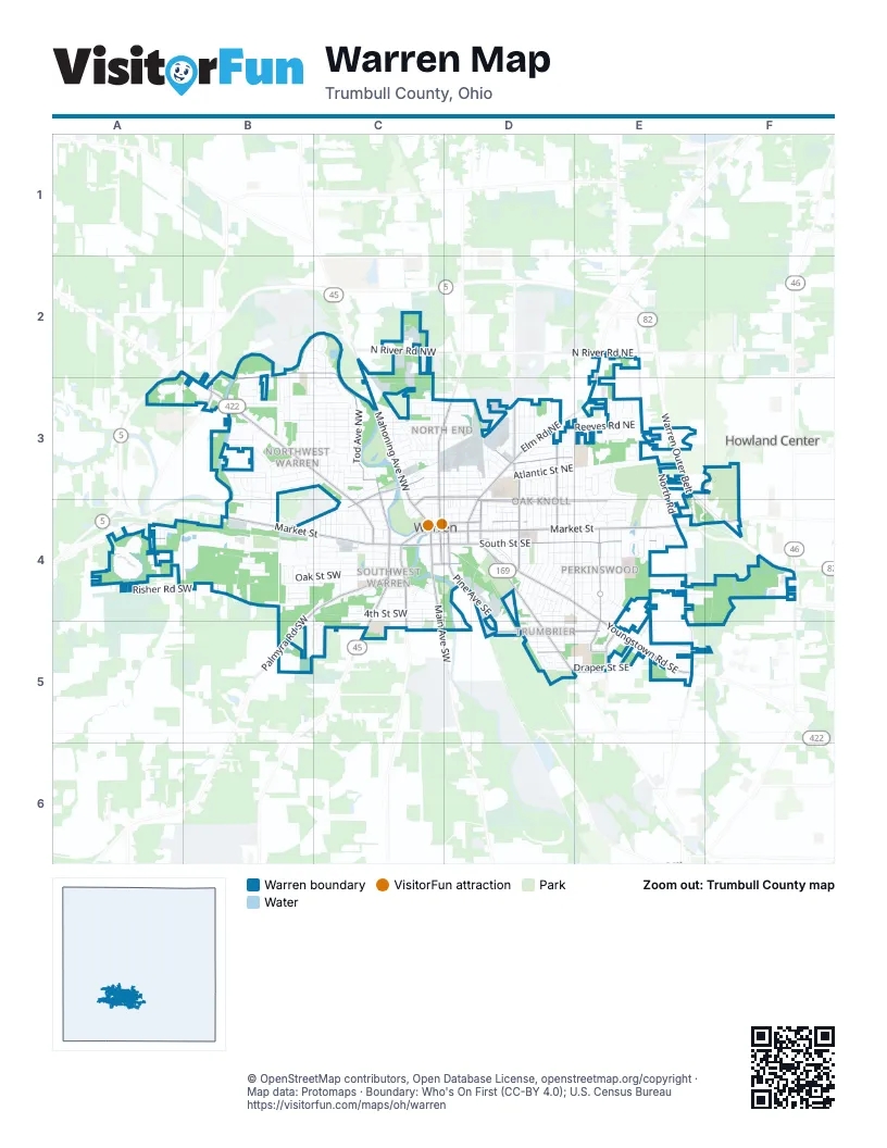
Street index of Warren
Each street on the sheet and the grid squares it crosses.
- Warren Outer BeltA3, E3, E4, F4
- East Market StreetC4, D4, E4, F4
- Parkman Road NorthwestB2, B3, C3, C4
- West Market StreetB4, C4
- Youngstown Road SoutheastD4, E4, E5
- South Street SoutheastC4, D4, E4
- South Street SouthwestA4, C4
- Tod Avenue NorthwestB2, C2, B3, C3, C4
- Elm Road NortheastE2, D3, E3, D4
- Mahoning Avenue NorthwestC2, C3, C4
- Niles Road SoutheastD4, D5
- Main Avenue SouthwestC4, C5
- Tod Avenue SouthwestC4, C5
- Summit Street NorthwestC3, C4
- Niles Cortland Road SoutheastF4
- Elm Road SoutheastD4
- Niles Cortland RoadF4
- North RoadE2, E3, E4, E5
- Central Parkway Avenue SoutheastE4, E5
- North Park AvenueC3, D3, C4
- Woodland Street NortheastD4, E4
- Palmyra Road SouthwestC4, B5
- Pine Avenue SoutheastD4, D5
- Burton Street SoutheastD5, E5
- Genesee Avenue NortheastD3, D4
- Highland Avenue SouthwestC4, C5
- North River Road NorthwestB2, C2, B3
- Hollywood Street NortheastD3
- High Street NortheastC4, D4
- Laird Avenue NortheastD3, D4
- Larchmont Avenue NortheastD3
- Ridge RoadE5
- Van Wye Street SoutheastD5, E5
- Washington Street NortheastC3, D3
- Laird Avenue SoutheastD4
- North Road SoutheastE5
- North Leavitt Road NorthwestB3
- South Park AvenueC4
- Chestnut Avenue NortheastD4
- Washington Street NorthwestC3, C4
- North River Road NortheastE2
- Fulton Street SoutheastC4, D4
- Chestnut Avenue SoutheastD4
- Burnett StreetA4
- High Street NorthwestC4
- Fulton Street SouthwestC4
- Pine Avenue NortheastD4
- Atlantic Street NortheastC3, D3, E3
- Oak Street SouthwestB4, C4
- Bonnie Brae Avenue NortheastD3, D4
- Front Street SouthwestB4, C4
- Willard Avenue SoutheastE4, E5
- 4th Street SouthwestC4, D4
- Belvedere Avenue SoutheastD4
- Southern Boulevard NorthwestB3, B4
- Hazelwood Avenue SoutheastD4, D5
- Lovers Lane NorthwestB3, B4
- Oak Knoll Avenue SoutheastD4
- Draper Street SoutheastD5, E5
- Eastland Avenue SoutheastE4, E5
- Union Street SouthwestB4, C4
- Meadowbrook Avenue SoutheastE4
- Adelaide Avenue SoutheastD4
- Woodbine Avenue SoutheastD4
- Northwest Boulevard NorthwestB3
- Reeves Road NortheastD3, E3
- Martin Luther King Boulevard SouthwestB4
- Trumbull Avenue SoutheastE4
- Perkinswood Boulevard SoutheastE4
- Kenilworth Avenue SoutheastD4
- Griswold Street NortheastC3, D3
- Lexington Avenue NorthwestB3
- Drexel Avenue NorthwestC3
- Hamilton Street SouthwestB4, C4
- Kenmore Avenue SoutheastE4
- Homewood Avenue SoutheastD4
- Dana Street NortheastC3, D3
- Brier Street SoutheastD5, E5
- Kenilworth Avenue NortheastD3, D4
- Risher Road SouthwestA4, B4
- Milton Street SoutheastD5, E5
- Mc Myler Street NorthwestB4, C4
- 3rd Street SouthwestC4
- Oakdale Drive NorthwestB3, C3
- Wick Avenue SoutheastD5, E5
- Belvedere Avenue NortheastD3, D4
- Vernon Avenue NorthwestC3
- Montclair Street NortheastD4, E4
- Vine Avenue NortheastD3, D4
- 5th Street SouthwestC4, C5
- Beal Street NorthwestB3
- Comstock Street NorthwestC3, D3
- Perkinswood Boulevard NortheastE3, E4
- Willard Avenue NortheastE3, E4
- Grandview Street SoutheastD4, E4
- Norwood Street NorthwestB3, C3
- Royal Troon DriveE4
- Kenmore Avenue NortheastE3, E4
- Linda Drive NorthwestB3
- Dodge Street NorthwestB3, C3
- Paige Avenue NortheastD3
- Risher RoadB4, C4
- Jackson Street SouthwestB4, C4
- Arthur Street NorthwestB3, C3
- Westwood Street NorthwestB3, C3
- Fairway Drive NortheastE3
- Dunstan Drive NorthwestB3, C3
- Sheridan Avenue NortheastD3
- Parkman Road SouthwestC4
- Estabrook Avenue NorthwestC3
- Austin Avenue SouthwestC4
- Rogers Avenue SoutheastD4, D5
- Edgewood Street NortheastD3
- Jefferson Street SouthwestB4, C4
- Ward Street NorthwestC4
- Nevada Avenue SouthwestC4
- Northfield Avenue NorthwestB3
- Post Street NorthwestC2, C3
- 2nd Street SouthwestC4
- Sussex Street SoutheastD4, E4
- Belle Street SoutheastD4, E4
- Porter Street NortheastC4, D4
- Montgomery Avenue NorthwestB2, B3
- Beechwood Street NortheastD3
- Crescent Drive NortheastE4
- Lynwood Drive NorthwestB2, C2
- Hall Street NorthwestC3
- Roselawn Avenue NortheastD3, D4
- Coit Drive NorthwestB3
- Adelaide Avenue NortheastD3, D4
- Riverview Street NorthwestC3
- South Leavitt RoadA4
- Thomas Road SoutheastD4, D5
- Maryland Street NorthwestC3, D3
- Monticello Avenue NorthwestC3
- Bradford Street NorthwestC3
- Beck Street SoutheastD4, E4, E5
- Clermont Avenue NortheastD3
- Fairmount Avenue NortheastD3, D4
- Country Club Drive NortheastE4
- Stewart Drive NorthwestB3, C3
- Parkwood Drive NorthwestB3, C3
- Duke Avenue SoutheastD5
- Delaware Avenue SouthwestB4
- North Street NorthwestC3
- Moncrest Drive NorthwestC3
- Belmont Street NortheastC3, D3
- Olive Avenue NortheastD3, D4
- Arlington Avenue NorthwestC3
- Williamsburg Street NorthwestB3
- Francis Avenue SoutheastD4
- Sferra Avenue NorthwestC2, C3
- Melwood Drive NortheastE3
- Southwest Boulevard SouthwestB4, B5, C5
- Fremont Avenue NortheastD3
- Red Fox Run Drive NorthwestB3, C3
- Buena Vista Avenue NortheastD3
- Clearwater Street NorthwestB3
- Victoria Street SouthwestB4, C4
- Peerless Avenue SouthwestB4
- Elm Hill Drive NorthwestB2, C2, C3
- Foster Drive NortheastE4
- Forest Street NortheastC3, D3
- Roosevelt Street NorthwestC3
- Country Club Drive SoutheastE4
- Douglas Street NorthwestC3, D3
- Randolph Street NorthwestB4
- Federal Street NorthwestC3, D3
- Maplewood Street NortheastD3
- York Avenue SouthwestC4
- Ogden Avenue NorthwestC3
- Merriweather Street NorthwestB3
- Denison Drive NorthwestB3, C3
- Overlook Drive NortheastE4
- Atlantic Street NorthwestC3
- Deerfield Avenue SouthwestC5
- Ferndale Avenue SouthwestB5, C5
- Reserve Avenue SouthwestB4
- Commerce Avenue NorthwestB3, B4
- Clarence Street SoutheastD4
- Lane Drive SouthwestC4, C5
- Enterprise Drive NorthwestB2, A3, B3
- Greenmont Drive SoutheastE4
- Pershing Avenue SouthwestB4
- Clearview Street NorthwestC3
- Colonial Street SoutheastD4, E4
- Golf Drive NortheastE3, E4
- Buckeye Street NorthwestC4
- Parkside Street NortheastD3, E3
- Stephens Avenue NorthwestB3
- Blakely Circle SouthwestC4
- Scott Street NortheastC4, D4
- Surrey Road SoutheastE4, E5
- Millikin Place NortheastE3
- East Avenue SoutheastD4
- West Avenue NorthwestC3
- Wallace Street SoutheastD5
- Butler Road NortheastE3, E4
- Belmont Street NorthwestC3
- Ohio Avenue NorthwestC4
- Berkshire Drive SoutheastE4, F4
- 1st Street SouthwestC4
- Arbor Avenue SoutheastE4, E5
- Bonnie Brae Avenue SoutheastD4
- Longhill Drive SoutheastE4
- Clemmens AvenueC3
- Broadway Avenue SoutheastE4
- Prospect Avenue NorthwestC3, C4
- Dickey Avenue NorthwestC4
- Mc Kinley Street NortheastD4
- Oak Knoll Avenue NortheastD3, D4
- Lodwick Drive NorthwestC3
- Greenfield Street NorthwestB2, C2
- Idylwild Street NorthwestC3
- Heather Lane NorthwestB3
- Garden Street NorthwestC3, C4
- Crestwood Drive NorthwestB2, B3
- Perkins Drive NorthwestC4
- Charles Avenue SoutheastD4
- Iddings Avenue SoutheastD4
- South Project Drive SoutheastD4, D5
- Edwards Court NortheastD3
- Forest Street NorthwestC3
- Niblock Avenue NorthwestC3
- Westview Drive NortheastD3
- Freeman Street NorthwestC3
- Candlelight Drive SoutheastE5, F5
- Wilson Avenue NorthwestC3
- York Avenue NorthwestC4
- Catalpa Street SoutheastE4
- University Street NortheastD3
- Irene Avenue NortheastD3
- Comberland Drive SoutheastF4, F5
- Robert Lane NortheastE3
- Bingham Avenue NorthwestC3
- Franklin Street SoutheastC4, D4
- Logan Avenue SoutheastD4
- Sweetbriar Street SouthwestB5, C5
- Cornell Street NortheastD3
- Wildwood Drive NortheastE3
- Harvard Drive SoutheastE4, E5
- Penn Avenue NorthwestC4
- Solar Street NorthwestB3
- Glenwood Street NortheastD3
- Maxwell Avenue NorthwestC3
- Oriole Place SouthwestC4
- Maple Street SouthwestC4
- Citadel Drive NortheastE3
- Choctaw Avenue SouthwestB4
- Dietz Road NortheastD3
- Mercer Avenue NortheastD3
- Stiles Street NorthwestC4
- Reo Street NorthwestC3
- Coventry Avenue NortheastE3
- Halsey Drive NortheastE4
- Lansdowne Avenue NorthwestB3
- Benton Street SoutheastD5
- Sunset Drive NortheastD3
- Aris Street NorthwestB3
- Maryland Street NortheastD3
- Swallow Street SouthwestC4
- Charles Avenue NortheastD4
- Douglas Street NortheastD3
- Monroe Street NorthwestC4
- North Feederle Drive SoutheastD4
- Crosby Street SoutheastD4
- Marwood Drive SoutheastE4
- Cranberry Lane NortheastE3
- Starlite Street NorthwestB3
- Brighton Avenue NortheastD3
- Iowa Avenue NorthwestC4
- Bronze Road NortheastD3
- Mike Place SouthwestC4
- Mason Street NorthwestC4
- Carlton NorthwestB3
- Edgehill Avenue SoutheastE4, E5
- Albert Street NortheastC3, D3
- Hayes Avenue SouthwestC4
- Sedgewick Street NortheastE3
- Kinsman Street NorthwestC3
- Bon Air Street NorthwestB2, C2
- Mazda Avenue NortheastD3
- Rex Boulevard NorthwestC3
- Guarnieri Drive NortheastD3
- Harrison Street NortheastD4
- Oak Circle SouthwestB4
- Raymond Street NorthwestC3
- Willow Drive SouthwestB4
- Hillsdale Drive NorthwestC4
- Bennett Avenue NorthwestB3
- Elm StreetA4
- Harmon Avenue NorthwestC4
- Northwoods Court NortheastE3
- Sunnybrook Drive SoutheastE4
- Logan Avenue NortheastD4
- Stonehenge Avenue NortheastE3
- Hoyt Street SouthwestC4
- Taylor Street NorthwestC4
- Haymaker Avenue NorthwestC4
- Englesson Drive NorthwestB2, B3
Things to do on the Warren map
Places on the map
- Advance Auto Parts
- Akron Children's Hospital - Warren Health Center
- Akron Children's Hospital Pediatrics - Warren Downtown
- Aldi
- Apostolic Christian Church
- AutoZone
- Baseball Stadium
- Best Western Park Hotel
- Blessed Sacrement
- Burbank Park
- Burger King
- Calvary Presbyterian Church;Calvary United Brethren Church
- CharBenay's
- Charity Baptist Church
- Charles Avenue Flower Power
- Church of the Holy Spirit
- Cockey BBQ
- Deemer Park
- Elm Road Drive in
- Environmental Transfer Systems
- Gould Stewart Park
- Highland Terrace Park
- Interfaith Park
- Jefferson School
- John F Kennedy High School
- John Novak Walking Path
- Lincoln Elementary School
- Lowe's
- Mahoning Side
- McGuffey PK-8
- Oakwood Cemetery
- Packard Park
- Perkins Park
- Pineview Memorial Park
- Quinby Park
- Saint Marys Cemetery
- The Market Place
- Trumbull Correctional Institution
- Union Cemetery
- Warren Olympic Club
Next to Warren
- Howland Center
© OpenStreetMap contributors, Open Database License, openstreetmap.org/copyright · Map data: Protomaps · Boundary: Who's On First (CC-BY 4.0); U.S. Census Bureau















