

Ohio map
Warren County map
About 256,059 people live here (Census Bureau, 2024 estimate). The sheet's index lists 72 streets; South Main Street, State Route 48 and Cincinnati Avenue cross the most grid squares. Things to do inside the boundary: Kings Island.
Open the map (PDF, US Letter)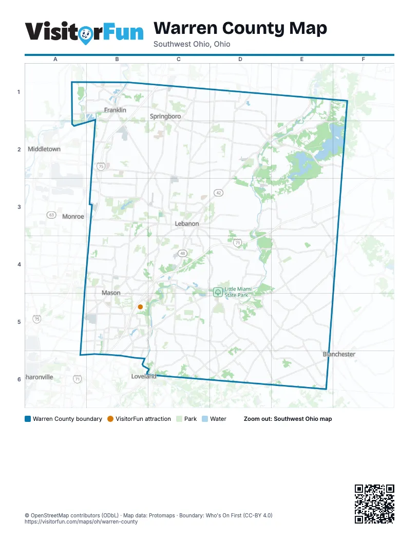
Street index of Warren County
Each street on the sheet and the grid squares it crosses.
- Carlisle PikeB1
- Central AvenueB1
- Dayton Cincinnati PikeB1
- East 2nd StreetB1
- East 6th StreetB1
- Kenneth Koons BoulevardB1
- Middletown PikeB1
- North Dixie HighwayB1
- North Main StreetB1, C1
- North Riley StreetB1
- North River StreetB1
- North Verity ParkwayB1
- Riley BoulevardB1
- South Main StreetB1, C1, B2, C2, D6
- South River StreetB1
- Van Horne StreetB1
- West 2nd StreetB1
- West 6th StreetB1
- West Central AvenueB1, C1
- East Central AvenueC1
- Main StreetC1, D5
- State Route 48D1, C2, D2, C5, C6
- Franklin Lebanon RoadB2
- Roosevelt BoulevardB2
- South Dixie HighwayB2
- State Route 122B2, C2
- East State Route 73D2
- Hamilton Lebanon Road EastB3
- State Route 63B3, C3
- Bypass 48C3
- Cincinnati AvenueC3, B4, C4
- Columbus AvenueC3
- East Main StreetC3, B4
- East Warren StreetC3
- Franklin RoadC3
- Miller RoadC3
- Neil Armstrong WayC3
- North Broadway StreetC3
- South Broadway StreetC3
- West Main StreetC3, B4
- Wilmington Lebanon RoadE3, F3
- Wilmington RoadE3
- Bethany RoadA4, B4
- Butler Warren RoadA4, A5, A6
- Mason RoadB4
- North Mason Montgomery RoadB4
- Reading RoadB4, A5, B5
- South Mason Montgomery RoadB4, B5
- State Route 741B4
- Anderson RoadD4
- South Nixon Camp RoadD4
- State Route 22/3E4
- Socialville–Fosters RoadA5, B5
- Tylersville RoadA5, B5
- Columbia RoadB5, B6
- Innovation WayB5
- Kings Island DriveB5
- Kings Mills RoadB5
- Mason Montgomery RoadB5, B6
- Mason–Montgomery RoadB5
- Socialville–Foster RoadB5
- West United States 22 and 3B5, C5
- West United States Highway 22 and 3B5, B6
- Western Row RoadB5
- United States 22 and 3C5
- East Pike StreetD5
- Mill StreetD5
- West Pike StreetD5
- Fields Ertel RoadB6
- North 2nd StreetC6
- Cincinnati-Wilmington PikeD6
- State Route 133E6
Things to do on the Warren County map
Places on the map
- 20-Mile Green
- ADESA Cincinnati/Dayton
- Aero Fulfillment Services
- Al-Char Lake
- Alverta
- Arbor Creek
- Arbor Square
- Armco Park
- Armco Park Golf Course
- Armco Park Lake
- Armor Business Park
- Ashley Place
- Ashmont
- Ashwood
- Atlas Roofing
- Atrium Medical Center
- Autumn Run
- Avalon Farms
- Avalon Heights
- Baymeadows
- Baywood
- Beacon Hill Condominiums
- Bel-Wood Country Club
- Bethesda Arrow Springs
- Birchwood
- Birchwood Farms
- Bishop Fenwick High School
- Bowman Park
- Brandywine on the Little Miami
- Brookstone
- Burr Hill
- Butlerville
- Butterfield Park
- Butterworth Glen
- Caesar Creek Gorge State Natural Area
- Caesar Creek Lake
- Caesar Creek Lake Emergency Spillway
- Caesar Creek Soaring Club
- Caesar Creek State Park
- Caesar Creek State Park Beach
Next to Warren County
- Blanchester
- Loveland
- Middletown
- Monroe
- Sharonville
© OpenStreetMap contributors (ODbL) · Map data: Protomaps · Boundary: Who's On First (CC-BY 4.0)