

Ohio map
Weathersfield Township map
About 24,420 people live here (Census Bureau, 2024 estimate). The sheet's index lists 300 streets; Salt Springs Road, Main Avenue Southwest and Ohltown McDonald Road cross the most grid squares. Also on it: Hilltop, Niles and Petro Stopping Centers.
Open the map (PDF, US Letter)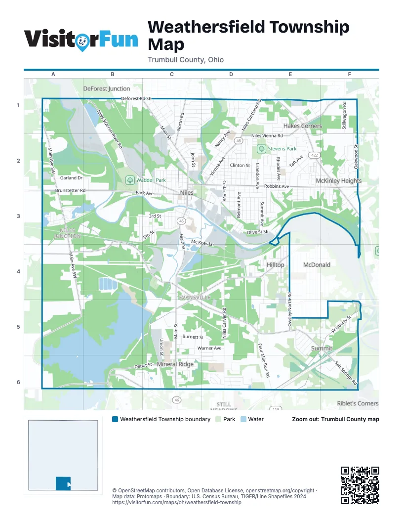
Street index of Weathersfield Township
Each street on the sheet and the grid squares it crosses.
- Youngstown Warren RoadE1, E2, F2, F3
- Salt Springs RoadA3, B3, B4, C4, C5, D5, E5, F5, F6
- South Main StreetC3, C4, C5, C6
- Robbins AvenueC2, D2, E2, F2
- North Main StreetC1, C2, C3
- Niles Cortland RoadD1, D2
- Vienna AvenueD2
- Tibbetts Wick RoadF2
- Main Avenue SouthwestA1, A2, A3, A4, A5, A6
- Ohltown McDonald RoadC4, D4, E4, C5, C6
- West Liberty StreetF5, E6
- Niles Vienna RoadE1, F1, D2, E2
- Warren AvenueB2, C2, C3, E4
- Depot StreetD3, B6, C6
- Brunstetter RoadA3, B3
- Carson Salt Springs RoadB3, A4, B4
- West Park AvenueB3, C3
- Niles Warren River RoadB1, B2
- Austintown Warren RoadA6, B6
- North RoadC1, C2
- Ohltown Girard RoadB6
- Deforest Road SoutheastB1, C1
- East Park AvenueC3, D3
- Owsley North RoadE4, E5
- North Chestnut AvenueC2, C3
- East County Line RoadD6, E6
- East State Street SoutheastC2, C3
- Marshall RoadF5
- McDonald AvenueE4
- Ohltown RoadB6
- North Four Mile Run RoadE6
- Niles Carver RoadD4, D5, D6
- Summit AvenueE2, E3
- Belmont AvenueD2, D3, D4
- 5th StreetB3, C3, D4, E4
- Trumbull AvenueC1, D1, E4
- Lincoln AvenueD2, C6
- Arms BoulevardD1
- Four Mile Run RoadD5, E5, E6
- Washington Avenue SoutheastD2
- Watson Marshall RoadD5, E5
- Olive Street SoutheastD3, E3
- West 3rd StreetB3, C3
- Anderson Morris RoadF1, E2, F2
- Hartzell AvenueD2
- Bentley AvenueD2, D3
- Mason StreetD3, E3
- North Rhodes AvenueE2
- Clinton StreetD2, E2
- Mc Kees LaneC3, D3, D4
- Hogarth Avenue SoutheastE2
- Morris StreetC6, D6
- Carnegie AvenueE2, E3
- Oakwood StreetF2
- Pearl StreetD2
- Lafayette Avenue SoutheastD2
- Roosevelt Avenue SoutheastE2
- Fenton StreetD3, E3
- Columbus AvenueC1
- Hunter AvenueC2
- Ann AvenueD3
- Mahoning Avenue SoutheastD2, D3
- Belle Terre AvenueE2
- Sharkey DriveB2, B3
- Chestnut StreetC5, E5
- Union StreetC5, C6
- Stillwagon RoadF1
- Burnett StreetC5, D5
- Hughes Street SoutheastD2
- Garland DriveA2, B2
- North Cleveland AvenueE2
- West Federal Street SoutheastC2
- Sheridan Avenue SoutheastC2, C3
- Henry Street SoutheastD3, E3
- Taft AvenueE2
- Meander DriveB6, C6
- Dragon DriveC2, D2
- 6th StreetE2, E4
- Oakview DriveE5, E6
- Bonnie Brae AvenueE2
- Cherry AvenueD2
- John StreetC2
- West StreetD2
- Warner AvenueC5, D5
- North Cedar AvenueD2
- Gardenland AvenueF2
- Fairlawn Avenue SoutheastC1, D1
- Wildwood DriveE4, E5
- Russell AvenueE2, E3
- Lawnview Avenue SoutheastC1, D1
- Pepperwood DriveD1, E1
- Prospect StreetC3, C5
- Camrose Drive SoutheastC1, D1
- Maple Street SoutheastC2
- North Crandon AvenueD2
- Heaton Boulevard SoutheastC1
- Scott AvenueD3
- South Cleveland AvenueE2, E3
- Mc Roberts Road SoutheastB2, B3
- Clark StreetE2
- Walnut Street SoutheastD3
- Orchard AvenueD2
- Baldwin AvenueD3
- High Avenue SoutheastD3
- Stepney Street SoutheastE3
- Peffer Avenue SoutheastD3
- Saint Mary's DriveD6
- Wood Avenue SoutheastD2, D3
- Frederick StreetD1, D2
- Fulton StreetD2, D3
- Indiana AvenueB3
- Morris LaneE5, F5
- Wilson AvenueC2
- Edwards StreetC6
- Holford Avenue SoutheastC2, C3
- Emerson AvenueC1
- Youngstown AvenueE4
- East Federal StreetC2, D2
- Bentwillow Drive SoutheastC1, D1
- Woodland Chase BoulevardD1
- Butterfield CircleE1
- Smith Street SoutheastC2
- Nancy AvenueD1, D2
- Hyde Avenue SoutheastC2, C3
- Harris StreetD2
- Helen AvenueC2, D2
- South StreetD3, E3
- Black Oak DriveE1, F1
- Royal Mall DriveD1
- Woodglen AvenueC2
- Upper HickoryA3, B3
- Brentwood BoulevardD1
- Summerberry LaneC1, D1
- North Arlington AvenueC2, C3
- Park Place DriveE2
- Dumont DriveD6
- Kearney Street SoutheastE2
- Saint John AvenueC1
- Harrison StreetC1
- Crestmont DriveF2
- Cassandra DriveC1
- Rosalyn DriveD6
- Arlington AvenueE4
- Pratt Street SoutheastD3
- Edgewater Pines Drive SouthwestA3
- Cynthia CourtD1, D2
- Harding AvenueC6
- Forest Glen RoadA3
- Wyoming AvenueC3
- Emmet Street SoutheastC1
- Fox Chase CourtD6
- Ford Street SoutheastD2
- Grant Street SoutheastD3
- Welsh Hill RoadE6, F6
- West State Street SoutheastC3
- Sayers Avenue SoutheastC2, C3
- Evaline Street SoutheastB1
- Beaver TrailD6
- Ward Avenue SoutheastC3
- North Langley Street SoutheastD3
- Williams Street SoutheastC2
- George StreetD2
- Old Forge Road SoutheastD1
- Allison StreetD3
- Jackson Alley SoutheastD2
- Eliza Avenue SoutheastC3
- Judyth Street SoutheastB1
- Dakota AvenueC3
- Furnace StreetC5
- Gypsy LaneD1
- Youll AvenueE2, F2
- Emma StreetC2
- South Bellwood AvenueF2, F3
- Ashland StreetC5
- Difford DriveD1
- Youll StreetE2
- Pittsburgh AvenueE4
- Hillcrest AvenueE3, F5
- Ashland Avenue SoutheastC1
- South Broadwat StreetC1
- James StreetE3
- Liberty StreetC1, C2
- Warner CourtC5, D5
- Blossom LaneC1
- Walnut StreetE5
- 10th StreetE2
- Clover Brook DriveD6
- Stanton Avenue SoutheastC3
- Shadow Ridge DriveE1, E2
- Grove Street SoutheastC1
- South Cedar AvenueD2, D3
- Shaw RoadD1, E1
- Isabelle DriveF2
- Sherman Avenue SoutheastC3
- Ruppell RoadC4
- Iowa AvenueC3
- Payne StreetC5
- Kelly StreetC5, C6
- Ohio Machinery BoulevardF6
- Highland Avenue SoutheastB2, B3
- West 4th StreetE4
- Nash AvenueC3
- Poplar StreetE5
- Lakeside DriveC5
- East Woodland AvenueC2
- Bowman StreetD2
- Whispering Pines Drive SouthwestA3
- Laura LaneC6, D6
- Andrea BoulevardD1
- Bianco AvenueF2
- Sunny Estates DriveE1, E2
- St Francis AvenueF2
- Ohio AvenueC2, C3
- Lily AvenueF2
- Cardigan StreetE3
- Farmdale AvenueD6
- Morse Avenue SoutheastD2
- Seaborn StreetC5
- Hiram StreetE2
- Mc Donald AvenueF5
- Mc Donald Avenue SoutheastE2, E3
- Hazel StreetE2
- Olive StreetE3
- Tripodi CircleE1
- Beaver AvenueD2
- Mc Kinley Avenue SoutheastE3
- South Glenwood AvenueF2, F3
- County Line RoadE6
- North Pleasant Avenue SoutheastC2, C3
- Denniston AvenueE4
- Battles AvenueC3
- Clay StreetD3
- Poplar Avenue SoutheastE2, E3
- Grandview Avenue SoutheastC1
- Karen DriveD5, D6
- Nebraska AvenueC3
- Lantern LaneE1, E2
- Parkway DriveB2, B3
- Neil Street SoutheastC2
- East Madison AvenueC2
- Elm DriveE5, E6
- Meadow Hill DriveD6
- Thomas Street SoutheastD3
- Plant Street SoutheastC2
- North Bellwood AvenueF2
- Crain DriveF1, F2
- Pheasant RunE2
- Blunt StreetC6
- Squirrel Run CourtD6
- Nob Hill DriveE1
- Mayfield AvenueD4
- Garfield StreetF2
- Gilbert Avenue SoutheastD2, D3
- Glenwood AvenueF2
- Valencia DriveB3
- Victor Avenue SoutheastC2, C3
- Harmon AvenueE2
- 7th AvenueE4
- Clearfield AvenueD4
- West 5th StreetD4, E4
- 8th AvenueE4
- Wade AvenueC2, D2
- 9th AvenueE4
- Sugar Pines Drive SouthwestA3
- Forest AvenueF2
- South Rhodes AvenueE2, E3
- Cannon StreetD2
- Longwood Avenue SoutheastF3
- Higley Avenue SoutheastE2, E3
- Hughes AvenueF5
- Ravine Court SoutheastE3
- Beech StreetE5
- Hickory Street SoutheastD2
- Carle AvenueD3
- Washington AvenueF3
- Arbor DriveD6
- Rosalyn CircleD6
- North Clover AvenueC2, C3
- Lakeside Way SouthwestA3
- Ellen AvenueF2
- Pine Alley SoutheastC2, C3
- Griffin StreetD2
- Franklin AvenueC2
- Beach StreetC1
- Merchant StreetC5
- West 2nd StreetC3
- Brightwood Avenue SoutheastF3
- Earl StreetB3
- Bellvue DriveE3
- Linden Avenue SoutheastD2
- Erie StreetD2, D3
- 9th StreetE2
- Country Pines Drive SouthwestA3
- Oxford AvenueC3
- Water Street SoutheastC3
- West 1st StreetC3
- Meadowlark LaneE2
- West Church StreetC3
- Carl StreetF2
- East Margaret Avenue SoutheastC2
Places on the map
- Bins A Plenty
- Blue Beacon
- Bo Rein Stadium
- Center Point Church
- Dollar General
- Dollar Tree
- Eastwood Mall Field
- Extra Space Storage
- Farmers National Bank
- First Christian Church
- First Church of the Nazarene
- Frank's Truck Wash
- Gasoline Alley
- Giant Eagle
- Goodwill
- Hilltop
- Kennedy Park
- Kingdom Hall of Jehovah's Witnesses
- Lincoln Elementary School
- McDonald's
- McKinley Birthplace Memorial
- McKinley Lanes
- McKinley Memorial Library
- McKinley Memorial Park
- Mr. Fuel Travel Center
- Niles
- Niles Middle School
- Niles Trailhead Park
- Niles Union Cemetery
- Petro Stopping Centers
- Pilot Travel Center
- Pinetree Square
- Saint Stephens Cemetery
- Seaborn Elementary School
- Speedco
- Stevens Park
- Waddell Park
- Welsh Hill Preserve
- Westwood Lake
Next to Weathersfield Township
- Bolindale
- DeForest Junction
- Ekerts Corners
- McDonald
- Parkside Estates
- Riblet's Corners
- Still Meadows
© OpenStreetMap contributors, Open Database License, openstreetmap.org/copyright · Map data: Protomaps · Boundary: U.S. Census Bureau, TIGER/Line Shapefiles 2024















